Mapping damage from space – DLR supports disaster relief in Beirut


Focus: Security, disaster relief, Earth observation
Following the devastating explosion in Beirut on 4 August 2020, which killed more than 150 people and injured thousands, a number of countries sent rescue teams and recovery experts to the Lebanese capital. On Wednesday, 5 August, a team from the Overseas Search and Rescue Rapid Deployment Unit (SEEBA) – part of the German Federal Agency for Technical Relief (THW) – set off for Lebanon on behalf of the German Federal Government to undertake a joint operation with I.S.A.R. Germany. Once there, the task force investigated and assessed the situation, searched for missing persons, assessed building damage and supported the German embassy. The German Aerospace Center's (Deutsches Zentrum für Luft- und Raumfahrt; DLR) Center for Satellite Based Crisis Information (ZKI) provided the team with damage maps. ZKI produced the maps at short notice and on its own initiative, using high-resolution satellite images acquired before and after the accident.
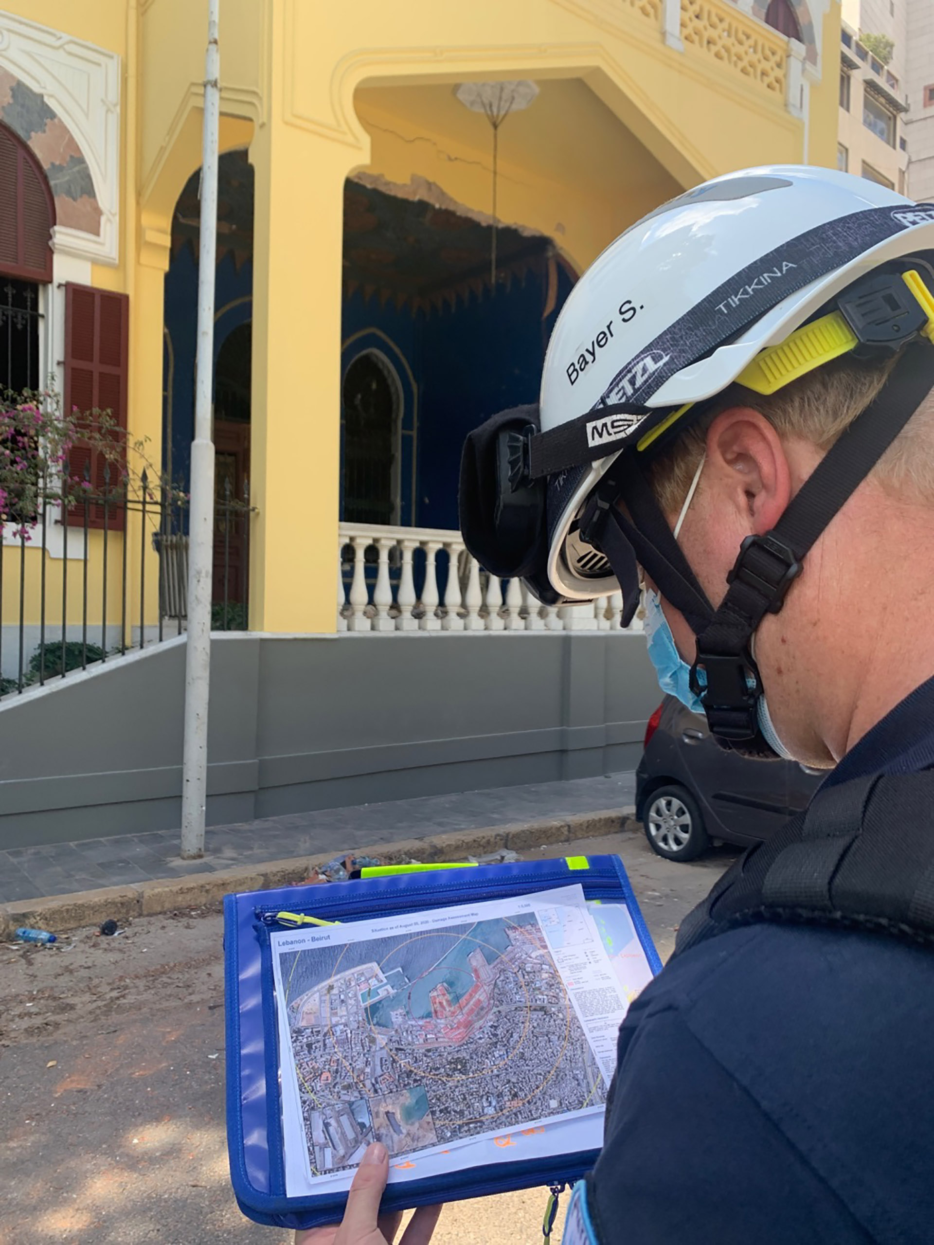
Steven Bayer, Deputy Head of Operations at I.S.A.R. Germany, was in Beirut for one week. There, among other assistance activities, he supported disaster relief workers in assessing the damage to buildings. ZKI's maps made a valuable contribution to this. Before joining I.S.A.R. Germany, Bayer was a security researcher at the DLR Institute for Optical Sensor Systems, during which time he was already an integral member of the aid organisation. Cooperation agreements exist between DLR, THW and I.S.A.R. Germany, through which DLR regularly makes use of its expertise in space and security research.
In an interview conducted upon his return to Germany, Bayer describes his experiences in Beirut.
Dr Bayer, you arrived in Beirut the day after the accident. What had you prepared for and what were your first impressions?
I was prepared for a more localised area of operation and different damage patterns to those found after natural disasters. With an earthquake, you see many collapsed or damaged buildings across a very large area. In Beirut, we were faced with major destruction radiating out from a central point, the severity of which decreased as the distance from the location of the explosion increased. The type of damage to buildings also differs between explosions and earthquakes.
After arriving at the airport, I went directly to the port area for a coordination meeting and then to undertake an initial damage assessment. The enormous damage in the port area clearly showed the power of the explosion.
What were your tasks on site?
I was part of the THW and I.S.A.R. Germany joint task force. Initially, I supported the THW's Head of Operations with coordinating the team in the Urban Search and Rescue (USAR) phase. This is the time period of about 100 hours after an accident during which you might find survivors and you exclusively search for missing persons and rescue them. I also regularly supported the German emergency teams at the scene of the accident. Following the completion of the initial phase, I assisted with the assessment of damaged buildings outside the port area.
Which data and technologies did you use to support crisis assistance?
We used the ZKI damage map for orientation and for the assessment of building damage that could not be seen from the ground. We considered using a camera drone equipped with the DLR-MACS reconnaissance system to obtain aerial images with even higher resolution. However, due to the relatively small area and the fact that a large part of that area is military territory, we did not use the drone.
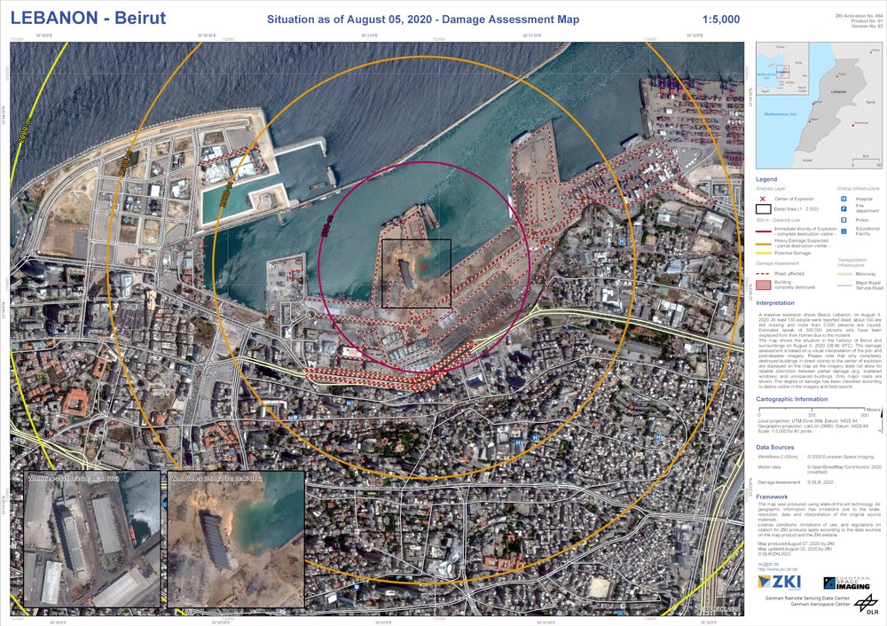
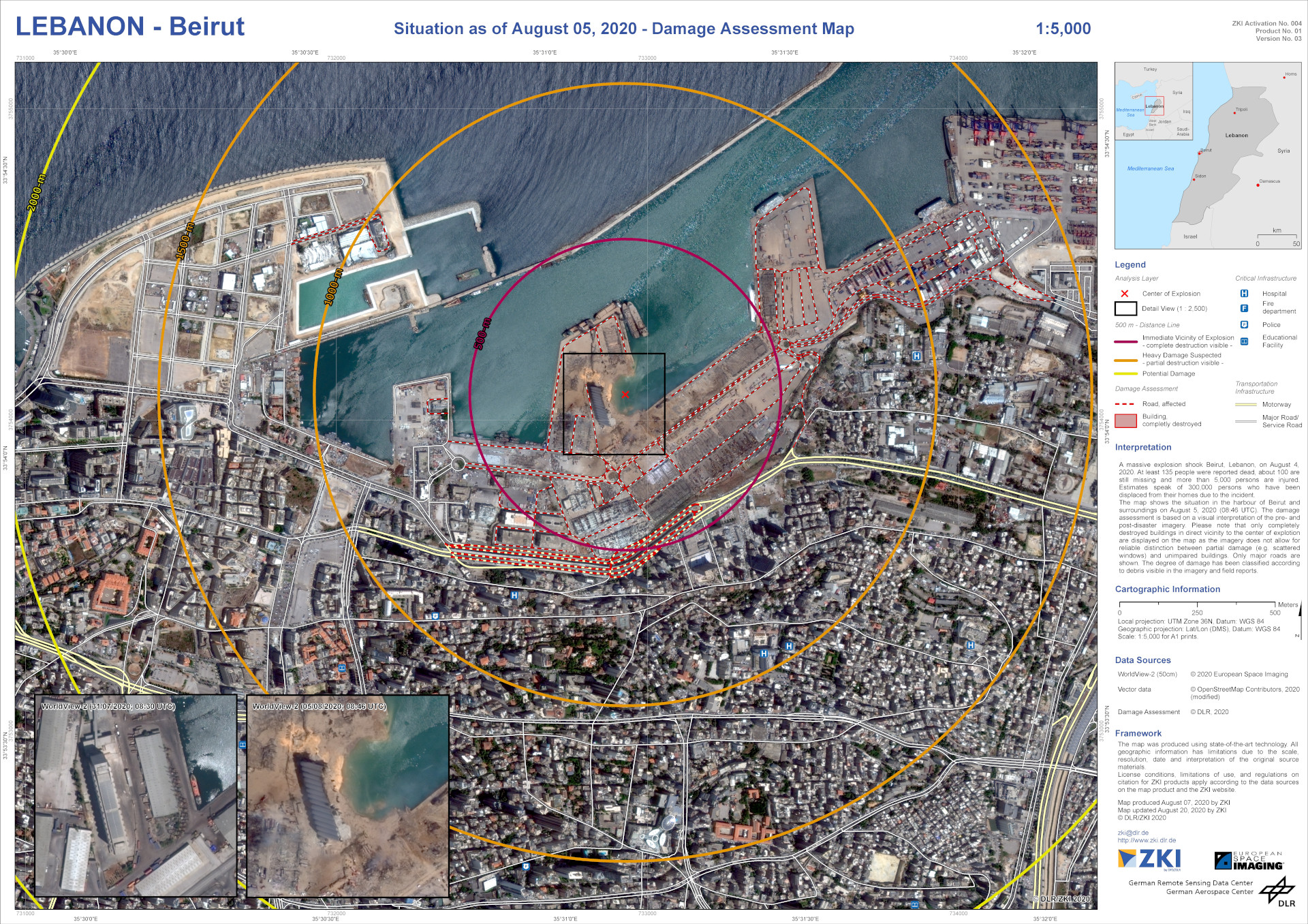
What is special about the damage maps produced by DLR's ZKI?
The damage maps made it possible for us to assess the extent of the damage on site, also from above. Beirut's urban area is very densely built up, so it was not possible to assess roof damage from the ground. In addition, the marked areas and distance lines offered a quick overview of the degree of destruction and change analysis provided us with excellent orientation to coordinate the assessment of building damage. One special feature was that the satellite data were available very quickly after the accident. From these, ZKI was able to produce special maps tailored to the on-site requirements very rapidly.
How can DLR security research contribute to further improving disaster relief?
In the event of a major disaster, up-to-date information is crucial for the effective coordination of all rescue services. With its range of projects and products, DLR security research is able to provide rescue teams with such up-to-date situational information. This allows for safer and more effective rescue operations – and can save human lives during an emergency.
The cooperation agreements between DLR and the rescue organisations I.S.A.R. Germany and THW ensure a continuous exchange of information between researchers and emergency services. This means that advances in research are closely coordinated with the needs and experiences of emergency services. The aim is to jointly develop new approaches to optimally support rescue organisations in their missions.
How would you sum up the mission? Was there an experience that you found particularly moving?
Many rescue teams were on duty in Beirut and worked together in a coordinated effort. Even though we were unable to locate any missing persons and rescue them alive, we were able to give the Lebanese government and their relatives the – albeit sad – certainty that there were no survivors in the area we searched, and that the search and rescue operation could be ended.
As in all our missions, the gratitude of the people for our help, and the solidarity of the people in Beirut, were points that particularly touched me again. Time and again, this is what gives me the strength to undertake our missions.
Many thanks for the interview.
Additional maps can be found here.
SEEBA emergency services are specialists in rescue and recovery in disaster areas such as those following earthquakes. Their rescue personnel are equipped with modern technologies and sniffer dogs to search for survivors. SEEBA teams can prepare for deployment within a few hours of being alerted. Their equipment is packed in lightweight metal containers that can be transported in conventional commercial aircraft. Among other operations, SEEBA was deployed following the severe earthquakes in Iran in 2003, Pakistan in 2005, and Japan in 2011. In 2017, SEEBA was reclassified as what is referred to as a ‘Heavy Team’ for earthquakes in accordance with the United Nations international framework guidelines (INSARAG Guidelines).
The German Federal Agency for Technical Relief (Technisches Hilfswerk; THW) is a voluntary deployment organisation of the German state. THW’s work in civil protection relies on the commitment of its approximately 80,000 volunteers nationwide, half of whom are emergency services personnel. With its expertise and diverse experience, THW is a much sought-after source of support for fire brigades, police, aid organisations and others. THW is also deployed worldwide on behalf of the German Federal Government. This includes provision of technical and logistical assistance within the context of civil protection in the European Union and on behalf of UN organisations.
I.S.A.R. Germany is a non-profit relief organisation. It was founded in Duisburg in 2003 and can be deployed worldwide. I.S.A.R. stands for 'International Search And Rescue' and is an association of specialists from various aid organisations and the German Rescue Dogs Association (Bundesverband Rettungshunde e.V.). Their task is to provide international aid during situations such as natural disasters, accidents and humanitarian emergencies. For this purpose, rescue dog teams and rescue specialists equipped with the latest technologies are deployed. In addition to the search and rescue of buried victims, medical care for victims of natural disasters and industrial accidents, such as the one in Beirut, plays an increasingly important role.