New climate guardian in space – Sentinel-6 will monitor global rise in sea levels


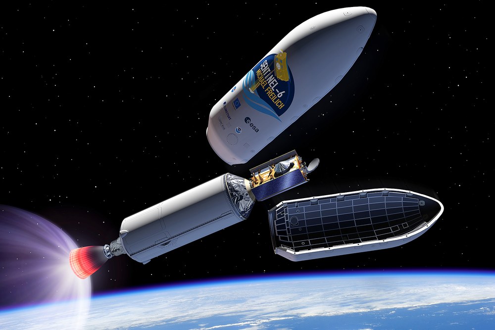
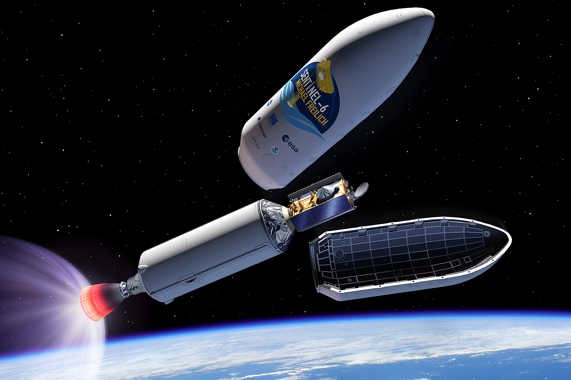
- On 21 November 2020 at 18:17 CET, the eighth satellite of the European Copernicus programme, Sentinel-6 Michael Freilich, is scheduled to lift off from Vandenberg Air Force Base in California (US) on board a Falcon 9 launcher.
- The mission will monitor sea level rise as well as recording sea state and ocean currents.
- The identical Copernicus Sentinel-6B satellite is scheduled for launch in 2025 and will continue making measurements into the next decade.
- Focus: Space, Earth observation, climate change
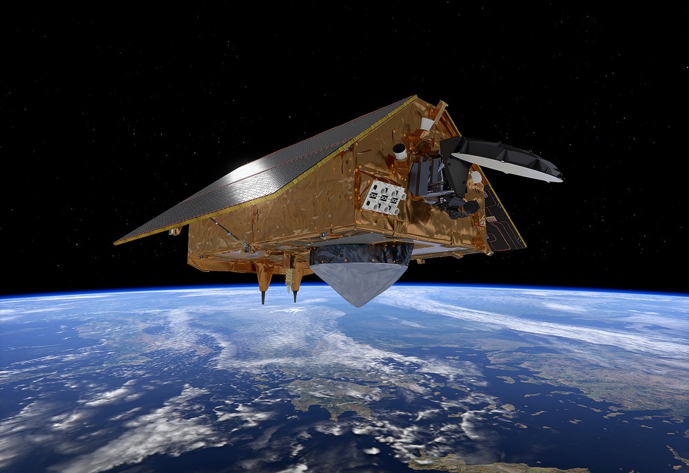
With the Sentinel-6 Michael Freilich satellite, a new 'climate guardian' will observe Earth from space. On 21 November 2020 at 18:17 CET (09:17 local time), the eighth satellite of the European Copernicus programme is scheduled to lift off from Vandenberg Air Force Base in California (US) on board a Falcon 9 launcher. "Climate change is one of the great challenges of our time," explains Walther Pelzer, a member of the German Aerospace Center (Deutsches Zentrum für Luft- und Raumfahrt; DLR) Executive Board and Head of the DLR Space Administration. "Sentinel-6 will help to continuously and reliably monitor global sea level rise. With this mission, we are therefore further expanding our leading role in space-based climate observation." In addition to sea level, Sentinel-6 Michael Freilich will also record the sea state and ocean currents. The satellite is expected to remain in service until at least 2025. After that, the identical Sentinel-6B satellite will continue the measurement series.
Sea level rise is more than three millimetres per year
At present, sea level is rising worldwide by an average of just over three millimetres per year and this is set to increase. Approximately half of this rise can be attributed to the effects of melting ice sheets and glaciers, the rest to the thermal expansion of the oceans as temperatures rise. "With this mission, we want to find out how sea levels will develop in the future," says Jörn Hoffmann, Programme Manager for Copernicus at the DLR Space Administration. "Satellite data can be used to assess, for example, whether political measures to limit climate change are effective and how well global climate models predict the development of sea levels."
In addition, Sentinel-6 will monitor the sea state and ocean currents. This information will enable conclusions to be drawn about heat transport in the oceans, which has a direct influence on the global climate. For example, the warm Gulf Stream is responsible for the relatively mild climate in northern Europe. This information is an important input variable for model calculations addressing climate development. All data from Sentinel-6 will be available to users free of charge.
Six scientific instruments will observe the oceans
Orbiting at an altitude of approximately 1300 kilometres, Sentinel-6 will observe Earth using six scientific instruments. The satellite’s main instrument is Poseidon-4. This radar altimeter will measure sea level rise with an accuracy of a few centimetres. Over longer time periods, it will thus be possible to determine long-term rates of change in the range of a few tenths of a millimetre per year. The measurements will also provide information on sea topography and waves.
A microwave radiometer, AMR-C, will determine the atmospheric water vapour content between Earth's surface and the satellite and use this value to make Poseidon-4’s height measurements more precise. The Doppler Orbitography and Radiopositioning Integrated by Satellite (DORIS) and Global Navigation Satellite System – Precise Orbit Determination (GNSS-POD) instruments, together with a Laser Reflector Array (LRA) will be used to determine the satellite's exact orbit. This precise information on the satellite’s trajectory will make it possible to determine the exact sea level. The accurate orientation of Sentinel-6 will be determined using a star tracker. A radio occultation receiver will be used to measure temperature and humidity in the different layers of the atmosphere.
For almost 30 years, high-precision satellite altimeters have been measuring sea level as an important indicator of climate change. Sentinel-6 Michael Freilich will now take over this task from the Jason-3 satellite launched in January 2016 and collect environmental data for at least five and a half years. The identical Copernicus Sentinel-6B satellite is scheduled for launch in 2025 and will continue the measurement series into the next decade. The first Sentinel-6 satellite is named 'Michael Freilich' in honour of the former Director of Earth Sciences at the US National Aeronautics and Space Administration (NASA), who passed away earlier this year, in recognition of his services to Earth observation and marine satellite observations.
European-US cooperation on Sentinel-6 Michael Freilich
The Copernicus programme is implemented by the European Commission together with the European Space Agency (ESA). Sentinel-6 Michael Freilich was developed as a European-US cooperation. In Europe, ESA and the European Organisation for the Exploitation of Meteorological Satellites (EUMETSAT) are involved, with the support of the French space agency (Centre national d'études spatiales; CNES). In the US, NASA and the National Oceanic and Atmospheric Administration (NOAA) are participating. Industrial leadership has been assumed by Airbus Defence and Space in Friedrichshafen, which also built the satellite platform, with key components supplied by small and medium-sized enterprises (SMEs) in Germany. The main instrument, the Poseidon-4 radar altimeter, was built by Thales-Alenia Space in Toulouse. The microwave radiometer AMR-C, the GNSS receiver and the laser reflector array were provided by NASA. On behalf of the German Federal Ministry of Transport and Digital Infrastructure (Bundesministerium für Verkehr und digitale Infrastruktur; BMVI), the DLR Space Administration is responsible for the ESA Copernicus Space Component Programme, which financed the development of Sentinel-6 Michael Freilich.
Copernicus – the European Earth observation programme
Copernicus is the European Union (EU) Earth observation programme, implemented in partnership with the European Space Agency (ESA). It serves to collect and evaluate Earth remote sensing data. These data are used by public authorities, commercial organisations, scientific researchers and interested citizens. To date, six families of satellites have been developed especially for Copernicus. They are known as Sentinels and record the state of Earth and its atmosphere and thus provide important data for climate protection, sustainable development, humanitarian aid and civil security. The satellite data are supplemented by measurements performed on the ground, in the air and from the water. Six further satellite missions were agreed upon at the ESA Ministerial Council Meeting in Seville in 2019. ESA and EUMETSAT are responsible for operating the 20 environmental satellites. In Germany, the Federal Ministry of Transport and Digital Infrastructure (Bundesministerium für Verkehr und digitale Infrastruktur; BMVI) is responsible for Copernicus. The DLR Space Administration in Bonn is supporting the implementation of the programme in Germany.