December 17, 2021 | German environmental satellite EnMAP completes its test campaign
Ready to launch
The German environmental satellite EnMAP is ready for its mission in space
The German environmental satellite EnMAP (Environmental Mapping and Analysis Program), which was developed and built in Germany on behalf of the German Space Agency at DLR with funding from the Federal Ministry of Economic Affairs and Climate Action (BMWK), is ready for launch.
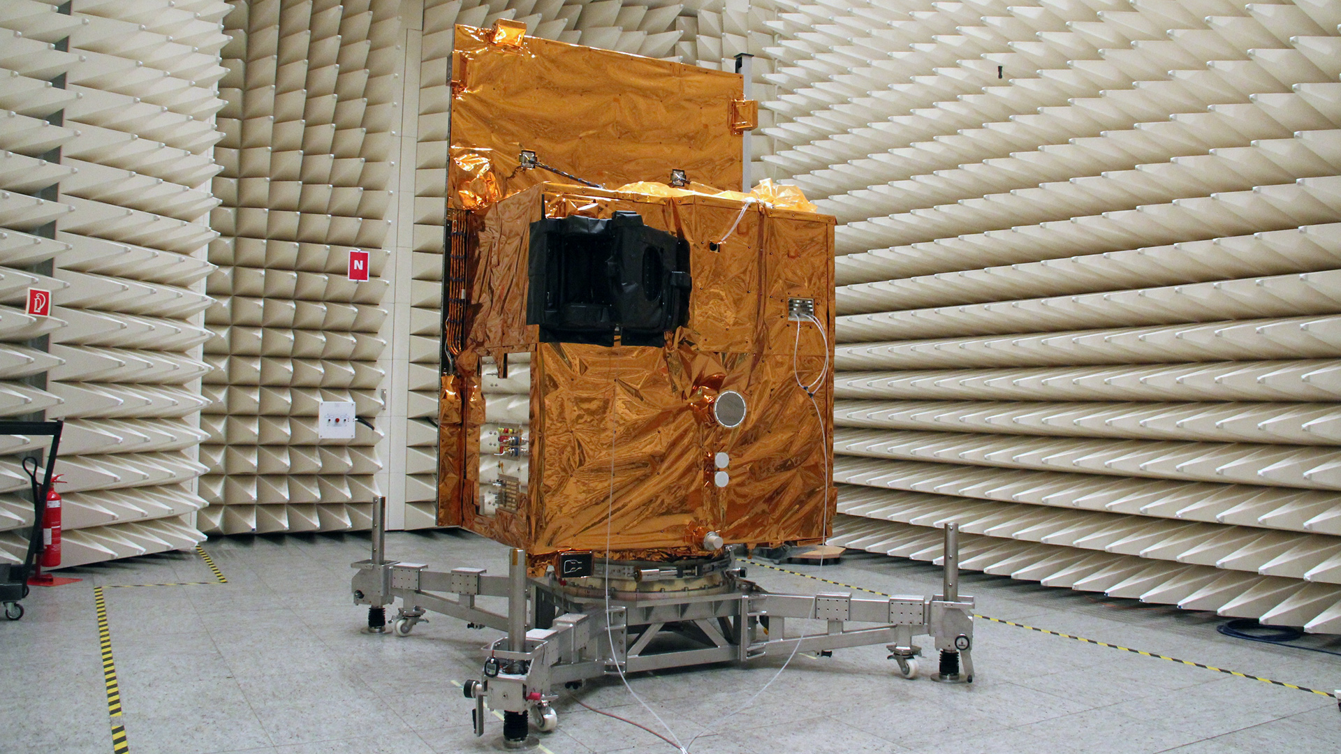
To survive its flight and stay in space undamaged, EnMAP had to be put through its paces beforehand. After all, the 'ride' on the rocket, extreme temperature fluctuations and the harsh radiation in space take a toll on the extremely sensitive instruments on board the satellite. Therefore, the satellite was subjected to a test campaign lasting several months at IABG's space test centre in Ottobrunn, near Munich.
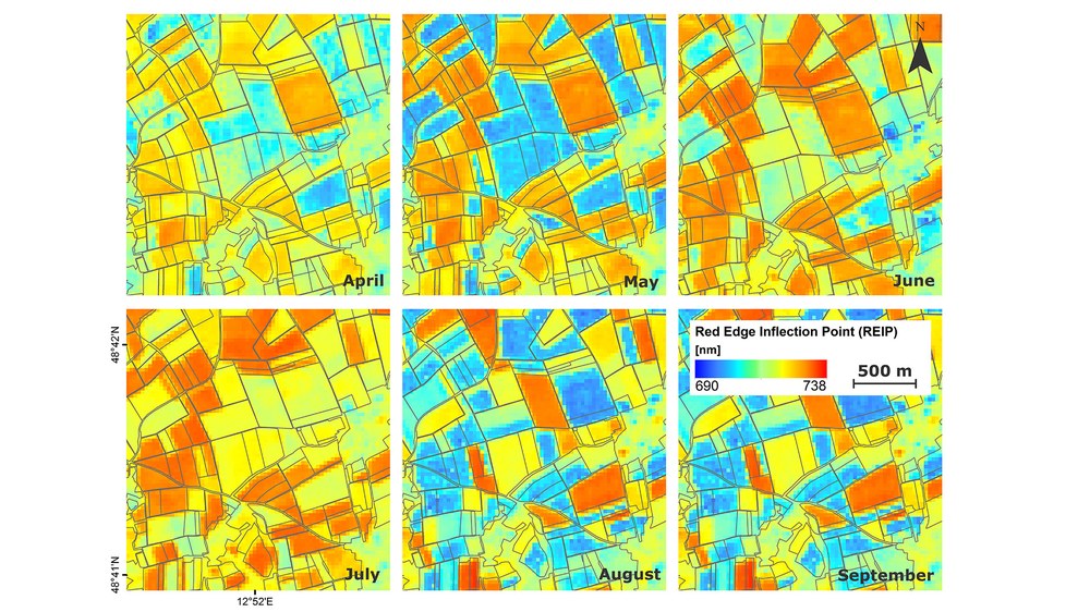
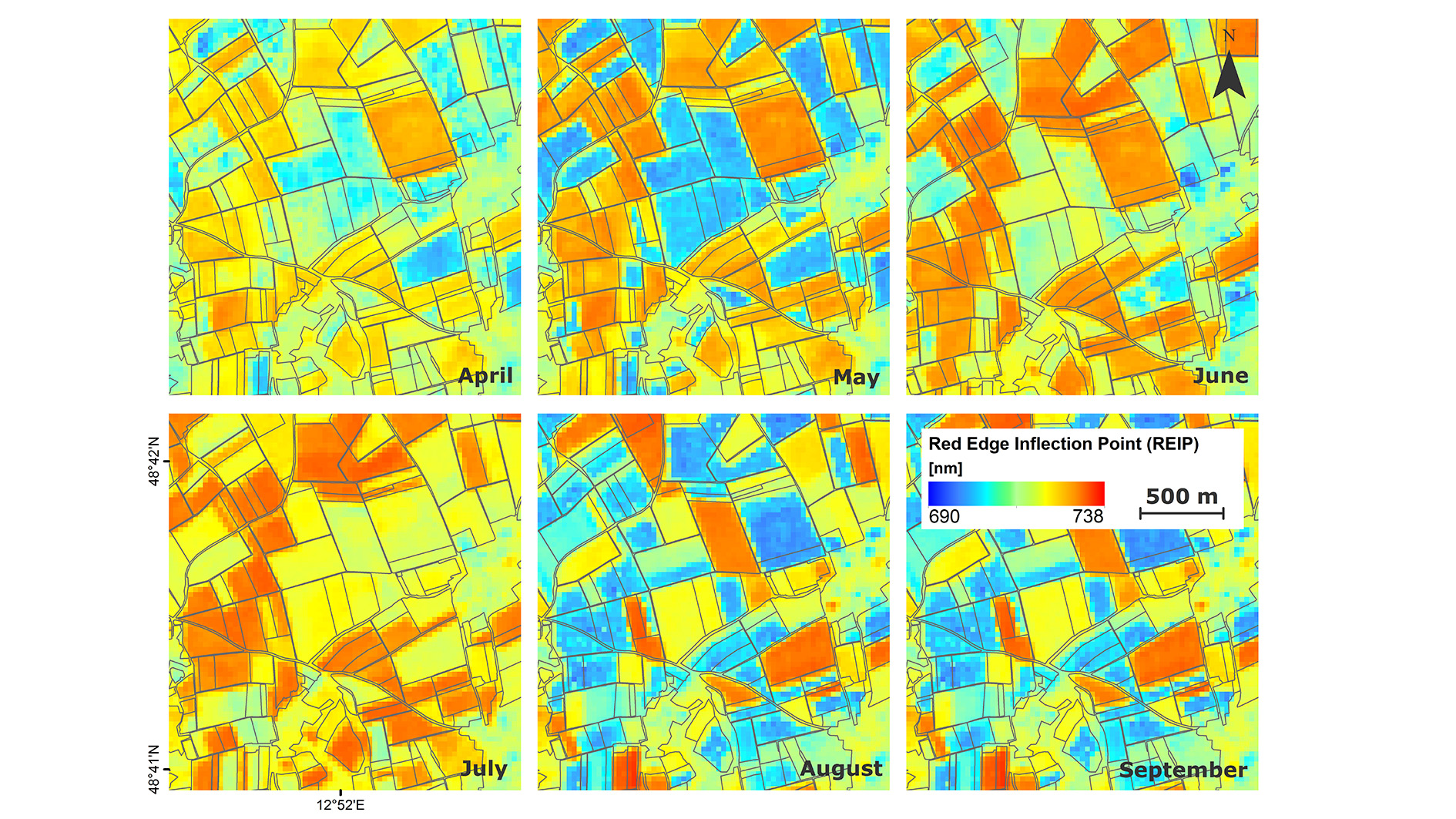
Special information products can be derived from EnMAP data, which can serve as a basis for decision-making in agriculture and thus lead to more sustainable land use. Compared to conventional multispectral Earth observation systems, hyperspectral imaging systems such as EnMAP guarantee a greater variety of observable variables, a higher accuracy of the information products by avoiding misinterpretations, and the comprehensive transfer of procedures for variable estimation that do not depend on calibration information from field measurements. The image shows simulated EnMAP time series of a growing season for an agricultural cropland near Neusling in southern Germany. The development of the 'Red Edge Inflection Point' (REIP) over time is illustrated, which can be an indicator of the current nutrient supply, among other things.
The German environmental satellite EnMAP (Environmental Mapping and Analysis Program) has successfully passed its final tests.
EnMAP is being developed and built by OHB System AG on behalf of the German Space Agency at the DLR, with funding from the Federal Ministry for Economic Affairs and Climate Action (BMWi).
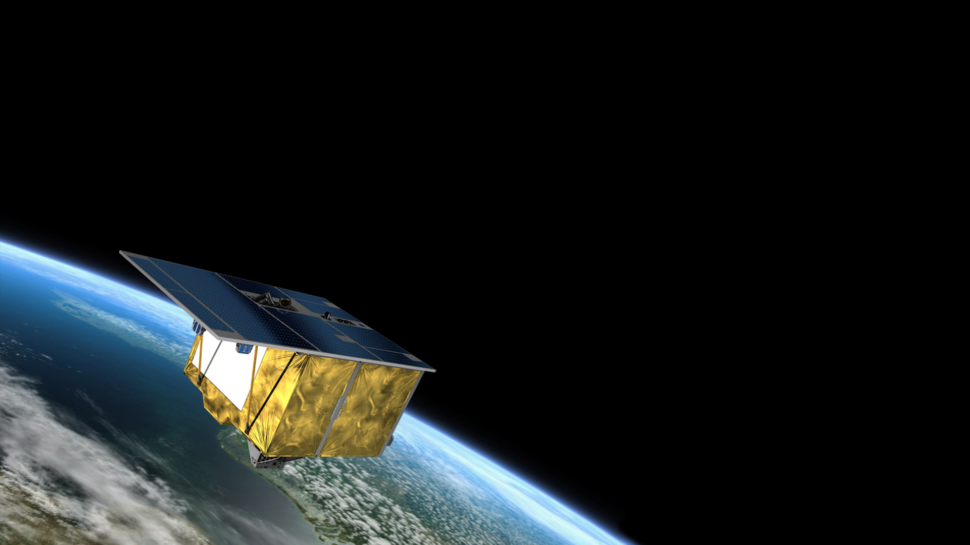
This first German hyperspectral satellite will be carried into orbit by a SpaceX Falcon 9 launcher. Once in space, it will gather data about Earth to help make life more sustainable.
Focus: Earth observation, climate change, environmental and nature protection
The journey has begun. The environmental satellite EnMAP, which has been developed and built in Germany on behalf of the German Space Agency at DLR with funding from the Federal Ministry for Economic Affairs and Climate Action (BMWi) and tested for use in space, is now ready to launch. "As a German environmental mission, EnMAP will look particularly closely at climate change and its effect on all ecosystems, on land and on water. Germany has not remained unscathed by such changes. The forests of this country have been heavily affected, as negative environmental influences have increased the stress that they are under. So far, most of the damage has been recorded in person by forestry officials – a mammoth task, with 90 billion trees are spread across an area of 11.4 million hectares," says Walther Pelzer, Member of the DLR Executive Board and Head of the German Space Agency at DLR.
One third of Germany's land area is covered in forest. "This is where EnMAP can help. With 242 channels, its hyperspectral instrument can 'scan' forest areas to determine the health status of trees and plants from an altitude of 640 kilometres," says Pelzer. Through the EnMAP mission, Germany is looking to make an important contribution towards the global monitoring of environmental changes to agriculture and forestry, soil science, geology, and research into coastal areas and inland waters. The satellite was developed and constructed by OHB System AG and tested for deployment in space by IABG mbH. The scientific management of the mission is the responsibility of the German Research Centre for Geosciences (GFZ), which is a member of the Helmholtz Association, as is DLR. The ground segment is being developed by DLR in Oberpfaffenhofen. By providing an accurate view from space, EnMAP is intended to help find solutions to address the challenges posed by climate change.
In future, for example, it will be possible to study plant metabolism over large areas and determine which areas are lacking in certain nutrients or which atmospheric pollutants are affecting the plants. "Despite the changing climatic and environmental conditions, the information from space should allow us to manage forests and fields in a more economical and environmentally sustainable way in future. That is why forestry workers and farmers alike will benefit considerably from EnMAP data," says Sebastian Fischer, EnMAP Project Manager at the German Space Agency.
In late February 2022, the satellite will be transported from the OHB AG premises in Bremen to the NASA spaceport in Cape Canaveral, Florida, on a Ilyushin Il-76 transport aircraft. From there, EnMAP will set off for its target orbit on board a SpaceX Falcon 9 launcher in April 2022. EnMAP will collect environmental data for at least five years.
Environmental testing as the basis for a successful mission
"In order to survive its flight and time in space unscathed, we had to really put EnMAP through its paces beforehand. The journey on the launch vehicle, extreme fluctuations in temperature and harsh radiation in space put a lot of demands on the highly sensitive instruments on board the satellite," says Fischer. With that in mind, the satellite was subjected to a test campaign over several months at IABG's space test centre in Ottobrunn, near Munich. "EnMAP passed the tests with flying colours. Its instruments and all of the technology worked very well under extreme conditions."
Tracking environmental changes with 242 channels
What is it that makes EnMAP special? How does this satellite work? All materials on Earth’s surface reflect sunlight in a characteristic way, referred to as a spectral signature. EnMAP can 'read' this signature with its instruments. However, in order to avoid confusion with other sources, these signatures need to be recognised with high precision. This is done using multi-channel images, known as hyperspectral images. Applying this method also allows scientists to identify and quantify the recorded materials directly. As an example, not only can they see which type of fruit is being grown in a field, but they can also determine how well it is supplied with nutrients. Minerals in soils can also be identified and quantified.
Extensive yet highly detailed
EnMAP does not just have the land mass in its sights, either. The hyperspectral instrument, with its two imaging spectrometers, will also take a close look at the coastal areas and inland waters in a wavelength range of 420 to 2450 nanometres. With a spectral resolution of 6.5 nanometres in the visible and near-infrared range and 10 nanometres in the short-wave infrared range, EnMAP sees details that are hidden from the human eye. Its hyperspectral instrument makes pollutants in lakes and coastal waters visible and allows them to be quantified with precision.
Previously, water samples had to be taken, at great expense, but in the future a view from space will be sufficient to determine water quality over a large area. The same applies to mineral samples – when determining the degree of soil pollution, for example. This could prove useful in the wake of accidents at chemical plants and in other scenarios. "Instead of exposing people to the risk of collecting samples on site, a risk-free view from space will be sufficient in future. As the EnMAP satellite can be directed 30 degrees either side of the nadir track, it can examine any point on Earth’s surface every four days, with a spatial resolution of 30 metres. Comparatively rapid changes, such as erosion processes or plant growth, can be documented very effectively using this method," explains Fischer.
EnMAP – the German environmental mission and its partners
The EnMAP environmental mission is managed by the German Space Agency at DLR in Bonn on behalf of the Federal Ministry for Economic Affairs and Climate Action (BMWi). OHB-System AG was commissioned to develop and build the satellite and its hyperspectral instrument. The German Research Centre for Geosciences (GFZ) in Potsdam is the scientific lead for the study. Three DLR institutes and facilities have been commissioned to set up and operate the ground segment: the German Space Operations Center in Oberpfaffenhofen will conduct and monitor satellite operations, while the German Remote Sensing Data Center and the DLR Remote Sensing Technology Institute will archive, process and validate the received satellite data and make them accessible to users in the scientific community. Companies and public authorities will also be able to look at the data and use it to prepare future services. The use of EnMAP hyperspectral data by universities and scientific institutions and the development of special applications will be supported by BMWi funding programmes.


