Island in a lake of lava – the Martian volcano Jovis Tholus
January 26, 2022 | Mission Mars Express
Island in a lake of lava – the Martian volcano Jovis Tholus
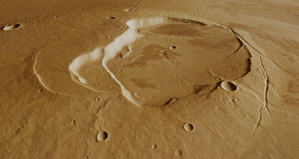
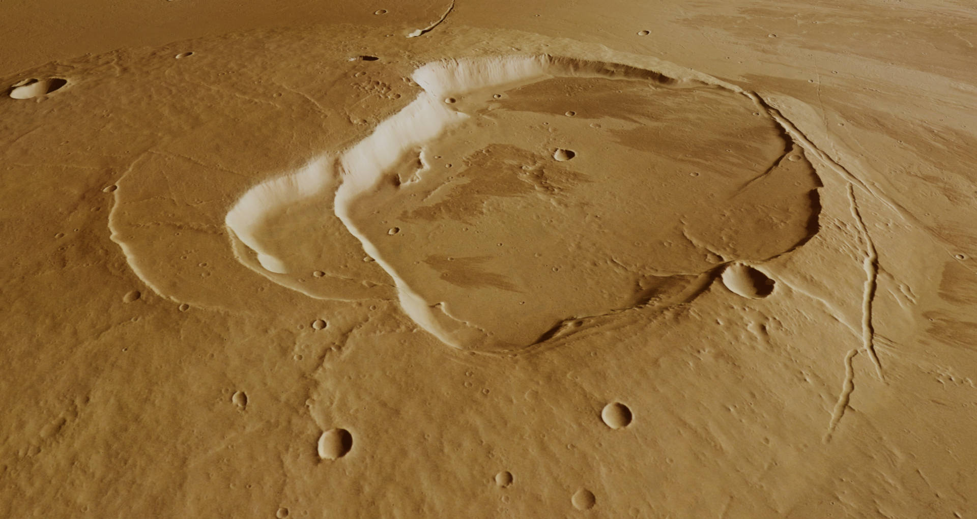
Oblique perspective view of 'Jupiter's Dome'
With the digital terrain models generated using data acquired by the stereo imaging channels of the High Resolution Stereo Camera (HRSC) on board ESA's Mars Express spacecraft, perspective views of the Martian landscape can be created. This image shows a view of the eastern side of the 1500-metre-high Jovis Tholus shield volcano – the 'Dome of Jupiter'. The volcano's 28-kilometre-diameter caldera consists of a total of five craters, suggesting a long period of volcanic activity. The individual calderas are connected to one another, the younger ones in each case having a slightly lower floor, which shows that the ceilings of the magma chambers that used to be below them have collapsed deeper and deeper.
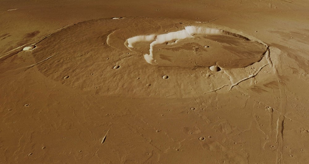
Oblique perspective view of the Jovis Tholus shield volcano on Mars
This perspective view shows the southern flank of the Jovis Tholus shield volcano. Its caldera, the collapsed basin above the emptied magma chambers, consists of a total of five craters, all of which are interconnected. Tectonic grabens can be seen at the edges of the volcano and in its immediate surroundings.
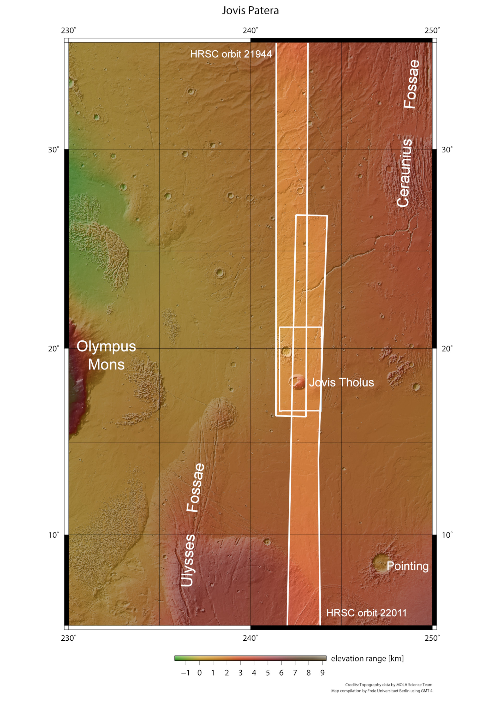
The Jovis Tholus shield volcano in the Tharsis region on Mars
The Jovis Tholus shield volcano is located in the Tharsis region on Mars. Tharsis was one of the most active volcanic regions, near the equator of the Red Planet. This is where most of Mars' volcanoes are located. The DLR-operated High Resolution Stereo Camera (HRSC) on ESA's Mars Express spacecraft imaged this landscape, located at approximately 242 degrees east and 19 degrees north, during Mars Express orbits 21,944 and 22,011. The western edge of the largest volcano on Mars, Olympus Mons, which is approximately 100 kilometres away, can be seen at the left-hand edge of this topographic map.
In addition to the giant volcanoes on Mars, countless smaller volcanic centres bear witness to a planet that was once very geologically active.
For 18 years, the DLR-developed High Resolution Stereo Camera on board ESA's Mars Express orbiter has been mapping Mars in high resolution, in colour and in '3D'.
Focus: Mars, planetary research, camera technology, space
These images, created using data acquired by the High Resolution Stereo Camera (HRSC) on board ESA's Mars Express orbiter, show the Jovis Tholus volcano and various other landscape features, such as tectonic faults, impact craters and solidified lava flows, in the Tharsis region of Mars. The Tharsis uplift, which is several kilometres high, was one of the most active volcanic regions near the Martian equator. With a diameter of almost 4000 kilometres, this plateau is almost as large as Europe. Most Martian volcanoes are located here, in particular four of the volcanic giants, with heights between 14 and 24 kilometres.
The HRSC was developed by the German Aerospace Center (Deutsches Zentrum für Luft- und Raumfahrt; DLR) and is operated by its Institute of Planetary Research in Berlin-Adlershof. Since 2004, it has been mapping Mars in high resolution, in three dimensions and in colour; it is carried on board ESA's Mars Express orbiter. The data acquired by HRSC an important resource for current and future Mars research. The findings already obtained in the course of the mission have greatly changed researcher’s theories about the geological evolution of the Red Planet.
Jovis Tholus (Latin – 'the dome of Jupiter') is a shield volcano. This type of volcano is formed by fluid, low-viscosity lava flows, creating an extensive cone with a shallow slope that resembles a flat shield. The lava is comparable to that ejected in 2021 by the Cumbre Vieja volcano on the island of La Palma in the Canary Islands. With a height of 17 kilometres (measuring from its submarine base to the summit), the largest shield volcano on Earth is Mauna Loa in Hawaii. Its counterpart on Mars is Olympus Mons, which rises 24 kilometres above the Tharsis uplift and is the largest known volcano in the Solar System.
Long period of volcanic activity
The comparatively small, 1500-metre-tall shield volcano Jovis Tholus lies, in a sense, in the 'shadow' of Olympus Mons, halfway between its 5000 to 6000-metre-high eastern escarpments and the 18-kilometre-high volcano Ascraeus Mons, the northernmost of the three shield volcanoes collectively referred to as the Tharsis Montes.
Jovis Tholus is located on the northern edge of an extensive lava plain, southeast of the Ceraunius Fossae graben system and northeast of the Ulysses Fossae graben system. The striking Jovis Tholus uplift has a diameter of 58 kilometres, similar in size to the island of Gran Canaria. Its caldera, which is comparatively large at 28 kilometres across, consists of a total of five craters, which suggests a long period of volcanic activity. The individual calderas are interconnected, the younger ones each having a slightly lower floor, which shows that the ceilings of the magma chambers that used to be below them have collapsed deeper and deeper.
Like most shield volcanoes, 'Jupiter's Dome' is surrounded by younger lava flows. They obscure many of the original landscape features – not even a crater rim is visible – and are therefore probably several hundred metres thick, like a 'stone lake'. They also cover a series of channels in the immediate vicinity of the volcano. Its eastern volcanic flank forms the steep rock face of a graben that continues northwards from there. Some parts of this graben can also be seen many kilometres further north in the plains. On closer inspection, the outlines of many individual lava flows can be seen on the lava surfaces. They consist of solidified basalt lava, which has a very low content of silicate minerals and water. Therefore, this lava is very inviscid, non-explosive and can flow or be displaced very far into the plain by the ‘lava supply’ – even on very shallow slopes – before solidifying.
A very interesting structure is located about 30 kilometres east of the volcano's flank. A second, less developed volcano rises here. It is best recognised in the topographical colour view in the lower right half of the image. Here, less fluid, more viscous lava probably emerged from a fissure. Such fissure volcanoes exist on Earth, for example in Iceland and Hawaii.
A 'muddy' impact
But these images reveal more than just volcanic structures. About 60 kilometres north of Jovis Tholus is an impact crater, 30 kilometres in diameter, whose ejecta blanket has a special form. Its morphology suggests that the ejecta had a rather fluid consistency and was distributed around the crater depression like mud that was 'mobilised' in a way similar to a pool into which stones have been thrown and deposited in a similar form; this is referred to as 'fluidised ejecta'. To form such a layer of ejecta, water or ice must have been present in the subsurface, which was liquefied or vaporised during the impact.
In addition, several outflow channels with separate strata that are 0.5 to 3.4 kilometres wide originate directly on the northwestern edge of the sharp graben that bounds the impact crater (and appears to cut through the upper left corner of the images as if created with a knife). Water was apparently released there in surges, forming streamlined islands and terraced channel walls. Several much smaller channels run through the northern ejecta blanket of the large impact crater. Researchers suspect that these large amounts of water were released by a pressurised aquifer while the faults were forming, or that volcanic heating caused the ground ice to melt, and the water then took the easiest route through the gully system to the surface.
These HRSC images provide many insights into a fascinating active planetary history with impacts, volcanoes, tectonic faults and flow channels.
Image processing
These images were created using data acquired by the High Resolution Stereo Camera (HRSC) on 13 May 2021 and 2 June 2021 during orbits 21,944 and 22,011 of the Mars Express spacecraft. The image resolution is approximately 17 metres per pixel. The centre of the image is located at approximately 242 degrees east and 19 degrees north. The perpendicular colour view was generated using data acquired by the nadir channel, the field of view which is aligned perpendicular to the surface of Mars, and the colour channels of HRSC. The oblique perspective views were computed using a Digital Terrain Model (DTM) and data acquired by the nadir and colour channels of HRSC. The colour-coded topographic view is based on a DTM of the region from which the topography of the landscape can be derived. The reference body for the HRSC DTM is a Martian equipotential surface (areoid).
HRSC was developed and is operated by the German Aerospace Center (Deutsches Zentrum für Luft- und Raumfahrt; DLR). The systematic processing of the camera data was performed at the DLR Institute of Planetary Research in Berlin-Adlershof. Personnel in the Department of Planetary Sciences and Remote Sensing at Freie Universität Berlin used these data to create the image products shown here.
The HRSC experiment on Mars Express
The High Resolution Stereo Camera (HRSC) was developed by the German Aerospace Center (Deutsches Zentrum für Luft- und Raumfahrt; DLR) and built in collaboration with partners in industry (Airbus, Lewicki Microelectronic GmbH and Jena-Optronik GmbH). The science team, which is headed by Principal Investigator (PI) Thomas Roatsch, consists of 50 co-investigators from 34 institutions in 11 countries.

