Satellite images show lack of snow in the Italian Alps
December 21, 2022 | Cause of water shortages
Satellite images show lack of snow in the Italian Alps
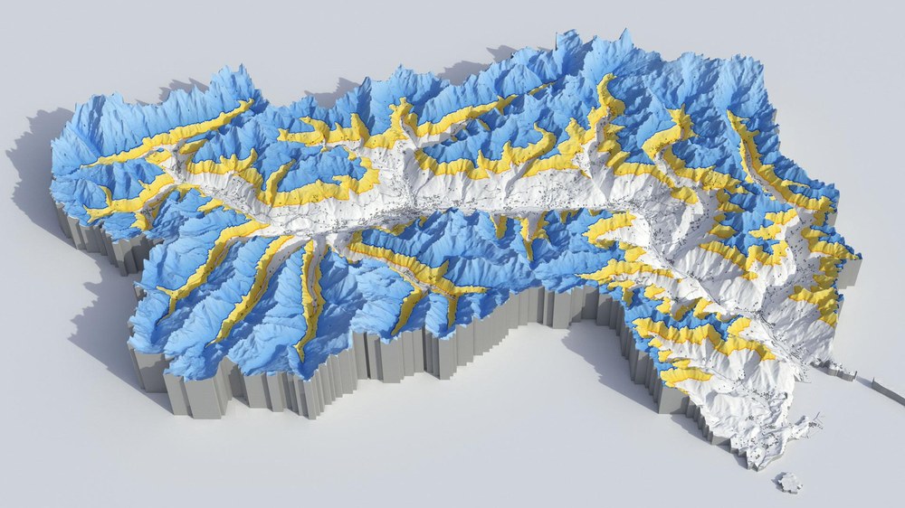
Change in snow line in the Aosta Valley (Northern Italy)
The Aosta Valley is located on the border with France and Switzerland in Italy. Mont Blanc, the highest peak in the Alps, can be seen in the northwest. The figure illustrates how the snowline has changed. The blue areas show the snow cover in March 2022. The yellow areas mark the average snow cover in March between 1985 and 2021. The data originate from Earth observation. The researchers analysed satellite images spanning 37 years.
The snow line in the Italian Alps last spring was at on average 400 metres higher than usual, and in some regions even almost one kilometre higher. This was determined by researchers at the German Aerospace Center (Deutsches Zentrum für Luft- und Raumfahrt; DLR). They analysed around 15,000 satellite images of the Alps over a period of 37 years. The scientists also investigated the effect of snow cover in the Alps on the water shortage in northern Italy. This year, northern Italy has endured one of the most severe droughts in the last 70 years.
Researchers from DLR's Earth Observation Center (EOC) analysed the position of the snowline in nine regions in the Italian Alps, including the Aosta Valley and South Tyrol. Important tributaries to Italy's largest river, the Po, originate here. In the spring in particular, rivers such as the Dora Baltea or the Adige are fed to a large extent by melt water. When there is no snow, Italy's most populous region faces water shortages.
"The snow line indicates the height at which the mountains are covered with snow. The higher this limit is, the less snow – and thus potential melt water – is available. For example, in Ticino, the border region between Italy and Switzerland, the snow line in March of this year was 625 metres above the long-term average. This meant that the region had 56 percent less snow cover than usual," says Jonas Köhler, who conducted the study at the EOC.
Earth observation helps to detect looming droughts at an early stage
The research team derived the results from images acquired by the Landsat Earth observation satellite. The data set contains monthly observations of the snow line for the entire Alpine region since 1985. Landsat has a spatial resolution of 30 metres. This allows snow to be mapped even in the complex terrain of high mountain regions. Because the Landsat archive reaches far into the past, time series can be created.
"The backdrop to the drought in northern Italy was a combination of high temperatures and little precipitation in the winter and spring of 2022, followed by several heat waves. Satellite images clearly show the effects of such weather conditions on snow cover," explains Jonas Köhler. Italian authorities restricted water use in regions such as Lombardy and Piedmont - affecting irrigated agriculture in the Po Valley. The consequences of a winter with little precipitation were also felt in Germany: the Rhine, for example, was in part no longer navigable due to low water levels. "Satellite data show that the snow line in large parts of the Alps is shifting upwards by several metres per year. Continuous observation of the snowline can help to identify possible droughts at an early stage in the future," adds Jonas Köhler.
