DLR develops mobile station for Satellite Laser Ranging

- Satellite Laser Ranging (SLR) can be used to determine the distance between a satellite and Earth very precisely.
- This is important for applications in geodesy, for satellite navigation and, in the future, for the operation of satellites and the management of large satellite constellations.
- With miniSLR, DLR has developed a mobile SLR station, which is easier to set up and maintain, can be operated automatically and is therefore much more cost-effective.
- Focus: Spaceflight, space situational awareness, laser technology, technology transfer
Satellite Laser Ranging (SLR) is a very precise, laser-based method for determining the distance between a satellite and Earth with an accuracy of a few millimetres. SLR is primarily used in geodesy. This is because the precise measurement of satellite orbits helps to determine changes in Earth's structure and rotation. The SLR method also makes important contributions in the field of satellite navigation. To date, the systems required for SLR have been large stations. Their construction is complex, costly and they require several people to operate them. The German Aerospace Center (Deutsches Zentrum für Luft- und Raumfahrt; DLR) has developed a much smaller, mobile version. 'miniSLR' is transportable, easier to set up and maintain and can be operated automatically. This makes it considerably cheaper than the usual SLR systems. The prototype of miniSLR has already delivered measurement data under realistic operating conditions that can compete with large stationary systems.
SLR technology – measuring with millimetre precision over a distance of several thousand kilometres
With SLR, a ground station emits a laser beam in the form of short pulses. This beam hits the targeted satellite, is reflected back and detected by the ground station using a telescope. The distance between the object and the ground station can be calculated very precisely based on the time it takes for the laser light to travel this distance. The satellite requires a reflector for the high-precision SLR process – similar to a reflector or cat's eye on a road. It also helps to know the approximate orbit data, using less precise radar measurements, for example. This is because with SLR, the satellite, which is sometimes several thousand kilometres away and travelling at a speed of more than 28,000 kilometres per hour, must be targeted with the laser beam.
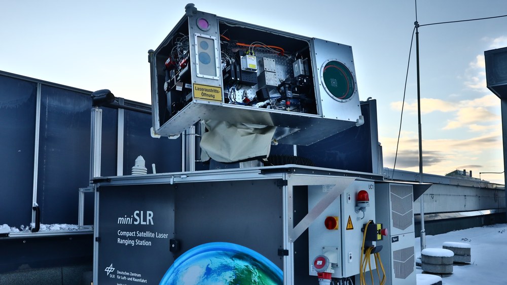
miniSLR – flexible, fully automatic, cost-effective – and yet highly accurate
The compact miniSLR system developed at the DLR Institute of Technical Physics in Stuttgart is box-shaped, fully enclosed and weighs approximately 600 kilograms. It is 1.8 metres long, 1.3 metres wide and two metres high. To use it, the researchers only need a stable surface and power and internet connections. In future, miniSLR will be operated fully automatically, which will also significantly reduce the operating costs of a station. The team is currently still controlling the prototype manually.
"Miniaturising the main components of miniSLR was a major challenge in the project," explains DLR researcher Wolfgang Riede. He is Head of the Active Optical Systems Department, where the project is based. "To keep the system as small and compact as possible, we use a diode-pumped solid-state laser. It has the necessary power but does not take up as much space. That is a decisive factor, because the telescope of the miniSLR is also smaller. Without a powerful laser, we would otherwise not get enough of the laser light back to be able to conduct successful measurements." In large stationary systems, the telescope has a diameter of 50 to 80 centimetres. The DLR system, on the other hand, requires only 20 centimetres. At the same time, the project team estimates that miniSLR can be three to five times less costly than conventional stations. These cost between three and five million euros.
High level of technology readiness – prototype works in a real environment
Over several years, the small team consisting of a handful of researchers developed, built and extensively tested an initial prototype of miniSLR. "In terms of accuracy, we have made good progress and produced a lot of valid measurement data. As early as 2023, we demonstrated that we could achieve the same accuracy as stationary SLR systems with our significantly simplified and more cost-effective station." To this end, the project team carried out measurements with several satellites and then compared these data with those from 35 conventional SLR stations.
With their previous work and the outdoor measurements, DLR researchers have shown that their prototype works in a realistic environment. miniSLR thus achieves a high Technology Readiness Level (TRL) of six. On a scale of one to nine, the TRL assesses the development status of new technologies on the way to commercial application. The many years of work performed by Institute of Technical Physics in the fields of optical and laser-based technologies provided the foundation for this achievement. This is because selecting the right laser for this particular application and combining the telescope, optical camera and laser beam guidance requires a great deal of expertise and experience. For the software, the project team was also able to draw on much of the Institute's work on laser-based detection of space debris.
The miniSLR team is currently working on further optimising the system. The aim is to go to market together with industry partners and launch small-scale production. DLR has already signed a licence agreement with the Potsdam-based company DiGOS to jointly build an improved prototype.
Opening up new fields of application for SLR – controlling satellite constellations
SLR is currently the most accurate technology for determining the location of a satellite. However, the process is dependent on relatively good weather, especially minimal cloud cover. In the future, SLR could also be used to measure the trajectory of other objects more accurately in space, for example space debris in the form of inactive or defective satellites equipped with a reflector. The Institute is therefore also campaigning to ensure that all new satellites are equipped with these. This would make it easier to avoid collisions between debris and active satellites. "With projects such as miniSLR, DLR is helping to open up more locations for SLR stations and find new applications for this technology, such as monitoring large satellite constellations as part of space traffic management. As ever higher accuracies are important for many satellite-based applications, there is great potential here," explains Wolfgang Riede.
The International Laser Ranging Service (ILRS) network currently has more than 40 active laser ranging stations worldwide. DLR's miniSLR is also listed there and provides data. The network offers the team the opportunity to constantly check the quality of their own measurements.