Olympia Planum – between dunes and steep ice cliffs
February 28, 2024 | Mars Express mission
Olympia Planum – between dunes and steep ice cliffs
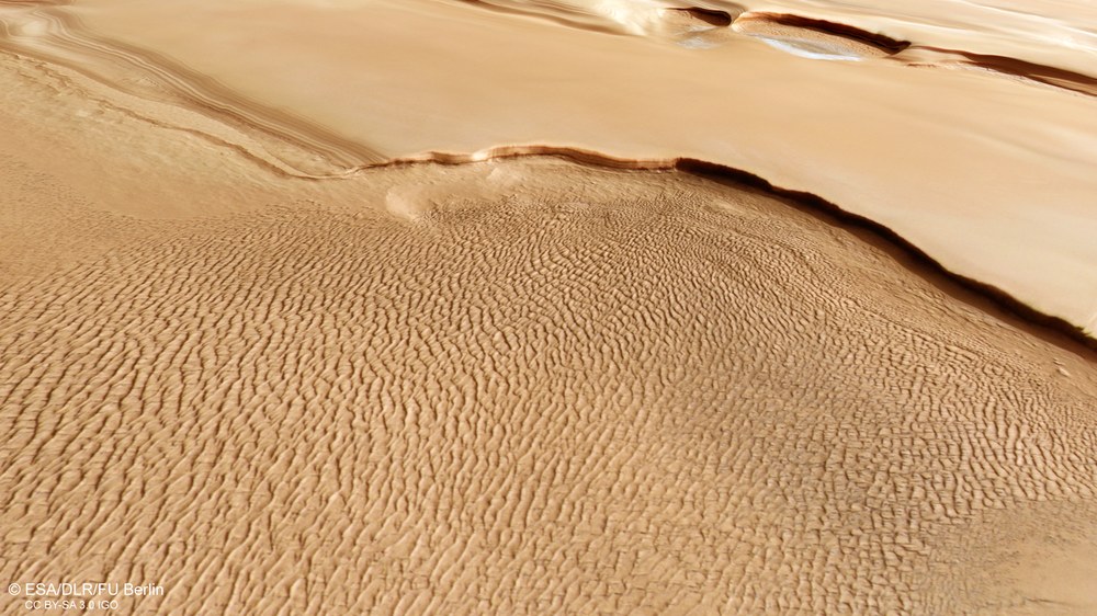
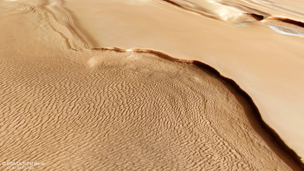
Dune fields in Olympia Planum
A dune field formed by strong, seasonally refreshing winds covers the vast plains of Olympia Planum. The origin of the dune sands lies in a cliff, 1000 metres high in places, which consists of alternating layers of ice, sand and dust. This is why no dunes can be seen above the cliff on the approximately 30 kilometre wide terrace. The edge of the terrain consists of the ice of the permanent north polar cap, which is covered in dust in most places, just like most of the dunes, which leads to the brownish colouring of the landscape forms in this scenery. Further north, in the background of the image, is a smaller dune field covered in light-coloured hoar frost, which also originated in the nearby edge of the terrain.
This section of the landscape in Olympia Planum near the north pole of Mars looks like a painter's watercolour with subtly graded pastel shades representing the different terraced levels. It was captured by the DLR HRSC stereo camera in April 2023 during the beginning of spring in the northern hemisphere of Mars. The distance from north to south (from right to left) is around 250 kilometres, while the distance from east to west in the centre of the image is around 100 kilometres. This covers an area slightly larger than the German state of Hesse. The extensive dune field in the left half of the image is more than 150 kilometres in length and extends further south (left). Such dune fields around the north pole of Mars bear some resemblance to so-called ergs, such as those found in the Sahara and on the Arabian Peninsula. At 470,000 square kilometres, the dune fields of the Olympia Undae erg near the north pole of Mars are comparable in size to the Rub Al-Khali in Saudi Arabia.
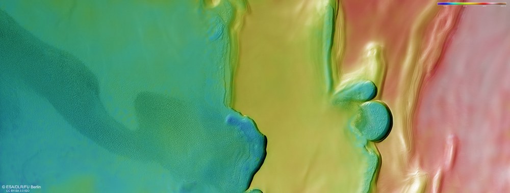
Its nine sensors, arranged at right angles to the north-south flight direction, record the surface of Mars from different angles and in four colour channels. From the four inclined stereo channels and the nadir channel, which is directed perpendicular to the surface of Mars, scientists at the Freie Universität Berlin and the DLR Institute of Planetary Research compute digital terrain models, which assign elevation information to each pixel. The elevation information can be interpreted from the legend at the top right of the image. They are related to the areoid, an imaginary surface of equal gravitational pull on Mars. This clearly shows the terraced structure of the ice cap, which is connected to the plains of Olympia Planum on the left-hand side of the image. The difference in altitude from south (left) to north is over 3000 metres.
Dust-covered layers of ice at the North Pole serve as a climate archive for Mars.
Mars' North Pole is covered by a three-kilometre-thick 'dusty ice cap'.
Thousand metre high cliffs provide a view of geological structures.
Focus: Spaceflight, planetary research, Mars
These images, created using data acquired by the High Resolution Stereo Camera (HRSC) developed and operated by the German Aerospace Center (Deutsches Zentrum für Luft- und Raumfahrt; DLR) on board ESA's Mars Express spacecraft, show a section of the Olympia Planum region, an area close to the permanent ice cap of Mars. Here, several steep scarps mark the boundary between the north polar ice cap and the lower-lying surrounding terrain with large dune fields. These vertical ice walls are up to 1000 metres tall and provide a Martian climate archive.
HRSC has been mapping Mars at high resolution, in three dimensions and in colour since 2004. Its data is an important resource for current and future Mars research. The study of the high northern and southern latitudes with their seasonally growing and shrinking ice caps is particularly important for deciphering the planet's recent geological past and ongoing atmospheric processes.
Changes on the surface of Mars through the seasons
Mars’ permanent north polar ice cap is a stack of water ice and dust layers up to three kilometres thick and approximately 1000 kilometres in diameter. These are divided into four stacked 'packets' of different thicknesses, which in turn are made up of finer layers. These layers contain information about the climate dating back several million years in the history of Mars. The deposits were formed by atmospheric precipitation of dust and water ice (in the form of snow) and by direct frost formation. They consist mainly of water ice, with fine dust sediments making up between 10 and 15 percent of the total. They probably reflect changes in the orbit of Mars and the inclination of the planet's axis of rotation, whose orientation is much more unstable than that of the Earth. It varies in several cycles with periods ranging from a few thousand to a few million years. The varying solar radiation results in a strongly varying climate, especially at the poles. It is assumed that the north polar ice cap is currently growing.
During the six-month Martian winter, an additional layer of carbon dioxide ice forms over the permanent water ice cap. The carbon dioxide precipitates out of the atmosphere and then sublimates completely in summer. As the planet's axis of rotation is tilted by 25 degrees – Earth's is approximately 23 degrees – in relation to its orbital plane around the Sun, Mars also has distinct seasons. However, due to its two-year orbital period, they are twice as long as on Earth. As on Earth in the Antarctic and Arctic regions, there are long polar nights with temperatures of down to minus 130 degrees Celsius. The images shown here were created using data acquired last spring in the northern hemisphere, where it is currently polar night, and the winter solstice is on 7 June 2024.
The polar cap itself has a smooth and pristine surface with some visible layers, but no impact craters. This means that the surface is very young and is probably covered with a new layer of dust every Martian year.
The extraordinary 'spiral arms' around the North Pole of Mars
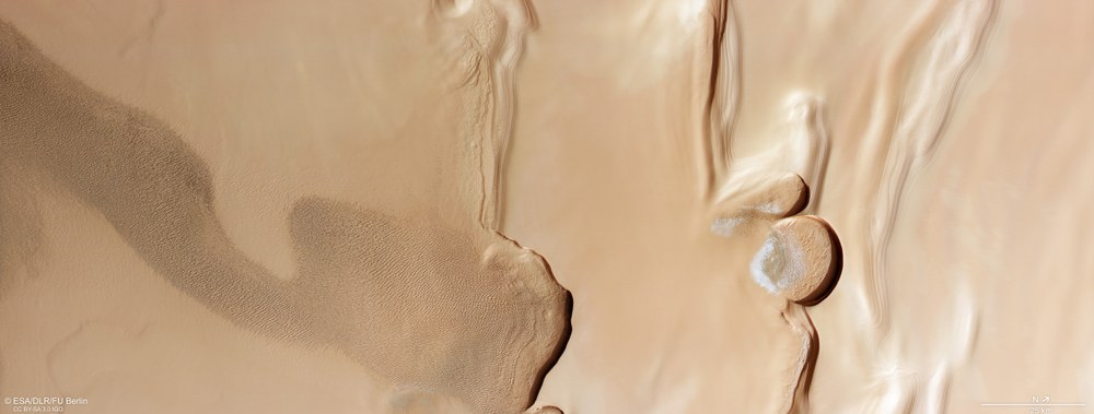
Also clearly visible in the images are two semi-circular cliffs, the larger of which has a diameter of 20 kilometres. They are located in what is referred to as a polar trough, a morphological feature created by the erosive force of the wind. These clockwise-oriented troughs create the characteristic spiral pattern of the polar plateau.
The cliffs in these HRSC images show a vertical wall of layered ice over one kilometre high in some places. The strong shadows cast emphasise their steepness. This becomes particularly clear when viewing the 3D image. Traces of pronounced erosion can be seen at the foot of the cliffs, exposing further layers. The areas within the trough are littered with large, frost-covered dune fields. Where the dunes are not covered by a layer of frost, they have a dark, grey-black colour.
Dune fields, ice and sediments in Olympia Planum
The sands of the dunes probably originated locally in the layered deposits of the cliffs. The sand that trickled out was swept up by the wind, forming a huge dune field on the plain in the left half of the image. Two smaller dune fields covered in light-coloured frost can be seen in the right part of the background, which also originated in the nearby edges of the terrain.
The elongated dune field shown in the pictures stretches for more than 150 kilometres. It is clear that the sands that form this dune field originate from the erosion of the polar deposits on the large scarps visible here. The morphology of the dunes also indicates the direction of transport of the sands, away from the cliff towards the south. This larger, more southerly dune field is not covered by a layer of frost, but by a thin layer of dust, which gives the dune field its brownish colour. At a greater distance around the north polar region are the Olympia Undae, the 'Waves of Olympia', a huge dune field that stretches over an area of 470,000 square kilometres between 78 degrees and 83 degrees north. This area is approximately the size of the entire Balkan Peninsula. Dark dune fields are very common on Mars, for example on the floor of numerous impact craters. However, the dunes found at the North Pole are special due to their mineralogical composition.
Back in 2005, shortly after the Mars Express orbiter arrived at Mars, the Observatoire pour la Minéralogie, l'Eau, les Glaces et l'Activité (OMEGA) instrument, a spectroscope for determining the mineralogy of the Martian surface, discovered high concentrations of gypsum (calcium sulphate with water molecules in the crystal lattice) on the dunes of Olympia Undae. These dunes are a fascinating object of study due to their unique gypsum composition, their proximity to polar ice deposits and their seasonal fluctuations. The High Resolution Imaging Science Experiment (HiRISE) on NASA's Mars Reconnaissance Orbiter has been acquiring high-resolution images of Mars since 2006 (but unlike the HRSC, not in 3D and not with its large area coverage). A particularly impressive view of steep layered slopes near the North Pole is shown this image of slipping boulders from May 2014.
Image processing
These images were created using data acquired by the High Resolution Stereo Camera (HRSC) on 14 April 2023 during Mars Express orbit 24354. The image resolution is approximately 21 metres per pixel. The centre of the imaged area is located at approximately 231 degrees east and 84 degrees north.
3D view of the steep scarp edges in Olympia Planum
Anaglyph images can be generated from the nadir channel of the DLR-operated HRSC camera system on the ESA Mars Express probe, which is directed vertically onto the surface of Mars, and one of the four oblique stereo channels. When using red-blue or red-green glasses, they enable a three-dimensional view of the landscape and give the viewer a spatial impression of the height differences. When viewed in this way, the terraced rise of the polar ice cap from the Olympia Planum plain towards the North Pole (outside the image on the right) with its cliffs up to 1000 metres high is particularly striking, but subtle differences in altitude can also be seen in the region's dunes or the deposited layers.
The colour image was created using data acquired by the nadir channel, the field of view of which is aligned perpendicular to the surface of Mars, and the colour channels of HRSC; the oblique perspective views were computed from data acquired by the stereo channels of HRSC. The 3D image (anaglyph image), which gives a three-dimensional impression of the landscape when viewed with red-blue or red-green glasses, was created using data acquired by the nadir channel and the stereo channels. The colour-coded image is based on a Digital Terrain Model (DTM) of the region, from which the topography of the landscape can be derived. The reference body for the HRSC DTM is an equipotential surface of Mars (areoid). The systematic processing of the camera data was carried out at the DLR Institute of Planetary Research. Personnel from the Department of Planetary Sciences and Remote Sensing at Freie Universität Berlin created the image products shown here.
The High Resolution Stereo Camera (HRSC) was developed at the German Aerospace Center (DLR) and built in cooperation with industrial partners (EADS Astrium, Lewicki Microelectronic GmbH and Jena-Optronik GmbH). The science team, led by Principal Investigator (PI) Daniela Tirsch from the DLR Institute of Planetary Research, consists of 52 co-investigators from 34 institutions and 11 nations. The camera is operated by the DLR Institute of Planetary Research in Berlin-Adlershof.
