German multispectral camera METimage set to improve weather forecasts
August 5, 2025 | Setting new standards in Earth observation
German multispectral camera METimage set to improve weather forecasts
German multispectral camera METimage to improve the quality of weather forecasts
Satellite data is one of the most critical components of weather forecasting. It provides accurate and comprehensive observations from regions of Earth that are poorly covered – or not covered at all – by other measuring instruments. Together with other observations, this data helps to determine the current state of the atmosphere as accurately as possible. Based on this, forecast models calculate how weather will develop over the coming hours and days. METimage will significantly improve these forecasts thanks to its precision. This will make it possible to warn of extreme weather events as early as possible and will also, for example, improve our understanding of climate change.
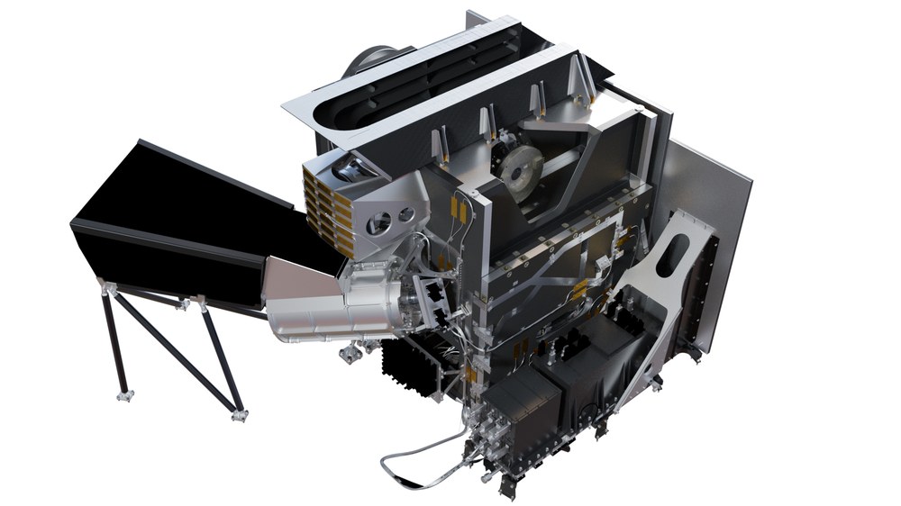
Digital model of the METimage multispectral camera
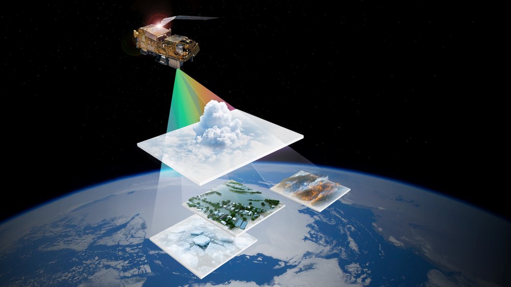
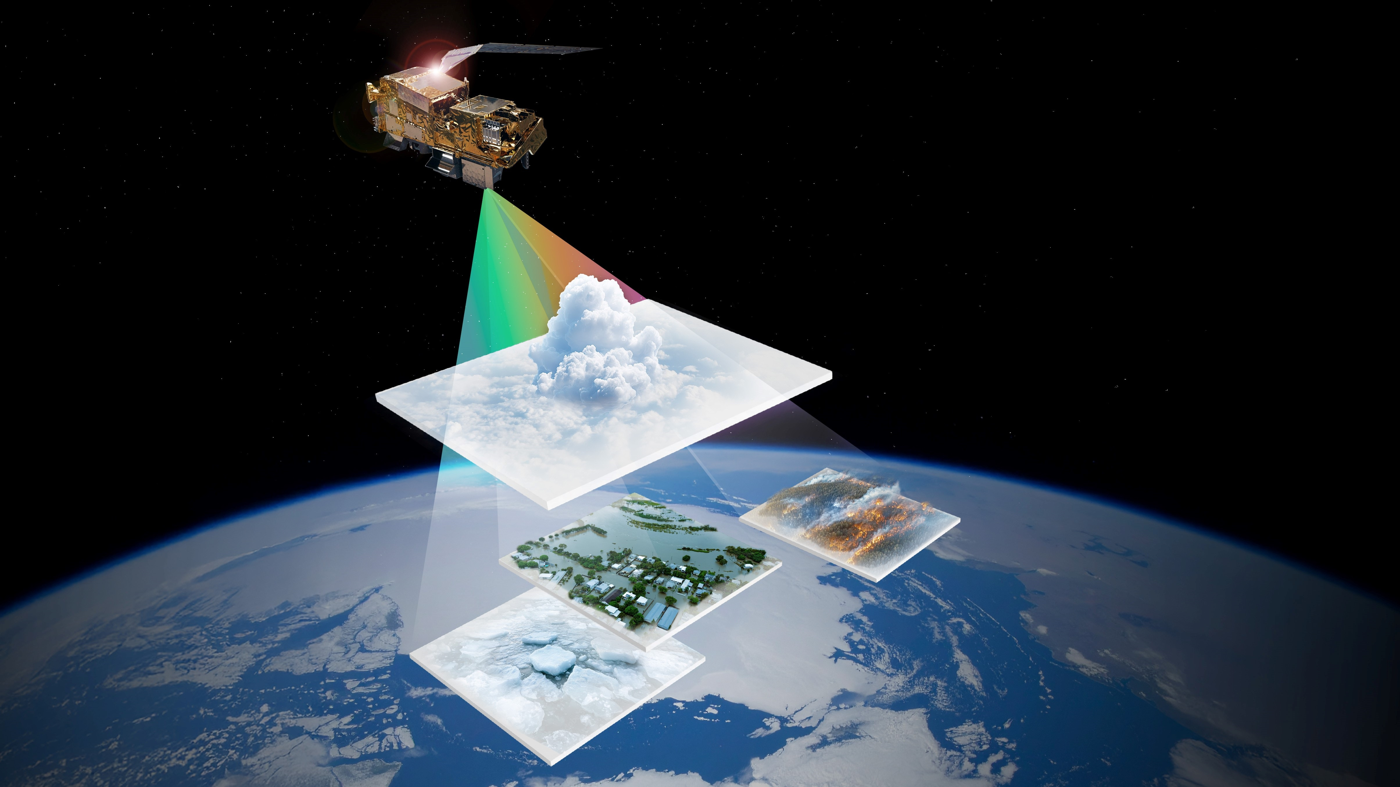
METimage records 20 different spectral channels – the 'colours' of visible and non-visible light – in a wavelength range from 443 to 13,345 nanometres. By comparison, the human eye can perceive three spectral channels in the red, green and blue ranges with wavelengths between approximately 400 and 700 nanometres. The spectral channels for METimage are selected to distinguish features such as clouds from snow and ice, even though both initially appear white to the human eye. Other spectral channels can be used to determine the height of clouds, the surface temperature of oceans, whether something green is in fact vegetation, or whether an area is on fire.
METimage to measure clouds with unprecedented accuracy
Whether there’s sunshine, rain or thunderstorms, clouds have a major influence on the weather and climate. Many different small scale physical and chemical processes lead to uncertainties in current weather and climate models. METimage will measure clouds with unprecedented accuracy and thus contribute to more precise weather and climate forecasts.
Image: 5/5, Credit:
EUMETSAT 2024
The Metop-SGA1 satellite will launch on 13 August 2025 at 02:37 CEST (local time 12 August at 21:37 DST), carrying among other instruments the state-of-the-art multispectral radiometer METimage.
METimage will deliver highly accurate global measurements of clouds, water vapour and aerosols, land- and sea-surface temperatures, ice cover, vegetation and wildfires.
The development and construction of METimage were coordinated by the German Space Agency at DLR.
At 02:37 CEST on 13 August 2025 (21:37 local time on 12 August), the Metop-SGA1 satellite of the European Organisation for the Exploitation of Meteorological Satellites (EUMETSAT) will lift off from Kourou, French Guiana, on an Ariane 6 rocket. The instruments on board will include the state-of-the-art METimage multispectral camera, which will significantly improve weather forecasting in Europe and around the globe. The design and construction of the instrument were coordinated by the German Space Agency at DLR (Deutsches Zentrum für Luft- und Raumfahrt; the German Aerospace Center) and financed by the German Federal Ministry of Transport (BMV) and EUMETSAT. The German Weather Service (DWD) supported the preparation of the mission by providing advice and in particular formulating requirements for weather forecasting and climate monitoring. METimage was developed and built by Airbus Defence and Space in Germany.
Highly accurate weather forecasts thanks to satellite data
Satellite observations are a cornerstone of weather forecasting. They provide precise, comprehensive data from regions of Earth that are inadequately or not at all covered by other instruments. Together with other observations, this data helps to determine the current state of the atmosphere as accurately as possible. On this basis, numerical models calculate how the weather will develop over the coming hours and days. The Metop-SG satellite series will significantly improve overall weather forecasting, but especially the upcoming two to six hours. Known as 'nowcasting', this is crucial for warning of extreme events, as in many cases the extent and consequences of such events cannot be predicted using long-term weather models. Metop-SGA1 with the METimage instrument – and the other second-generation Metop-SG satellites – will make a crucial contribution to nowcasting from polar orbit.
"Warning people of extreme weather events as early as possible is enormously important for public safety," says Patrick Schnieder, Federal Minister of Transport. "That's why, together with EUMETSAT, we are funding the METimage multispectral camera. By contributing this cutting-edge technology, Germany is setting new standards in precise climate observation and weather forecasting. METimage will improve weather forecasting not only in Europe but worldwide, enabling policymakers, public authorities and industry to obtain information about potential extreme weather events even earlier and initiate appropriate responses."
"The number of extreme weather events is increasing significantly," says Walther Pelzer, DLR Executive Board Member and Director General of the German Space Agency at DLR. "If we are to take timely measures to protect ourselves and our infrastructure, we need precise weather information. Our everyday weather forecasting is largely based on satellite data. Thanks to its high spatial resolution, METimage will make a key contribution towards improving forecast quality. Its spectral camera measurements will also provide essential data for global climate models and help us take the right action to combat the effects of climate change."
"The modernised and expanded instrumentation on board Metop-SGA1 will help us improve both our forecasts and the accuracy of our warnings, not least through the use of cutting-edge AI-based applications," says Sarah C. Jones, President of the German Weather Service (DWD). "The satellite's potential lies particularly in improving weather forecasting through expanded observational data for data assimilation. Metop-SGA1 also opens up opportunities for a more detailed look at clouds – examining their height, composition and droplet size. With the new data, we can evaluate how well clouds are represented in our existing forecast models and develop them accordingly. Metop-SGA1 data also has great potential for in-depth analysis, improving our understanding of the Earth system and helping us develop our climate models – the results of which will form the basis for national and municipal adaptation strategies."
Long-term commitment to global weather monitoring
Metop-SGA1 is part of the EUMETSAT Polar System – Second Generation (EPS-SG), Europe's contribution to the system of polar-orbiting meteorological satellites jointly maintained with the United States. EUMETSAT is responsible for the 'mid-morning' orbit, which crosses the equator at 09:30 local time.
The Metop-SG programme comprises six satellites: three consecutive pairs of A and B satellites carrying a variety of different but complementary instruments. The Metop-SG A satellites carry instruments for atmospheric sounding and imaging, while the B satellites carry instruments for microwave imaging and radar observations. Together they will ensure the continuity of the vital Metop data series until the mid-2040s. Metop-SG A satellites also carry the European Copernicus Sentinel-5 mission, built by Airbus and equipped with ultraviolet, visible, near-infrared and short-wave-infrared sensors for detailed measurements of atmospheric composition and trace gases.
The nominal operating life planned for the Metop-SG satellite series is 21 years, which will be covered by three identical satellite generations.
German technology for European meteorology
METimage hardware was developed, built and tested by Airbus Defence and Space together with more than 50 subcontractors. In addition to the first METimage model, which is now set to launch and is valued at approximately 300 million euros, two further flight models are currently in production. These are scheduled to launch on the Metop-SGA2 and A3 satellites in 2032 and 2039 respectively, to provide continuous weather data through the late 2040s.
Background information: The METimage instrument
Operating at an altitude of 830 kilometres, METimage scans a 2560 kilometre-wide strip of ground every 1.7 seconds, with a resolution of 500 metres per pixel. This is made possible with a rotating mirror that scans Earth’s entire surface every 12 hours. Alongside detectors that work in the visible spectral range, the instrument has infrared detectors that operate at temperatures below minus 200 degrees Celsius.
Using this technology, METimage can record 20 different spectral channels – like 'colours' of visible and non-visible light – in a wavelength range from 443 to 13,345 nanometres. (By comparison, the human eye can perceive three spectral channels in the red, green and blue ranges, with wavelengths between approximately 400 and 700 nanometres). METimage's predecessor, AVHRR, could record six spectral channels. The spectral channels for METimage are selected to distinguish features such as clouds from snow and ice, even though both initially appear white to the human eye. Other spectral channels can be used to determine the height of clouds, the surface temperature of an ocean, whether something green is actually vegetation or whether an area is on fire.

