Mars images reveal extensive signs of water ice in the Utopia Planitia impact basin
April 15, 2026 | Mars Express mission
Mars images reveal extensive signs of water ice in the Utopia Planitia impact basin
Subsurface ice in Utopia Planitia
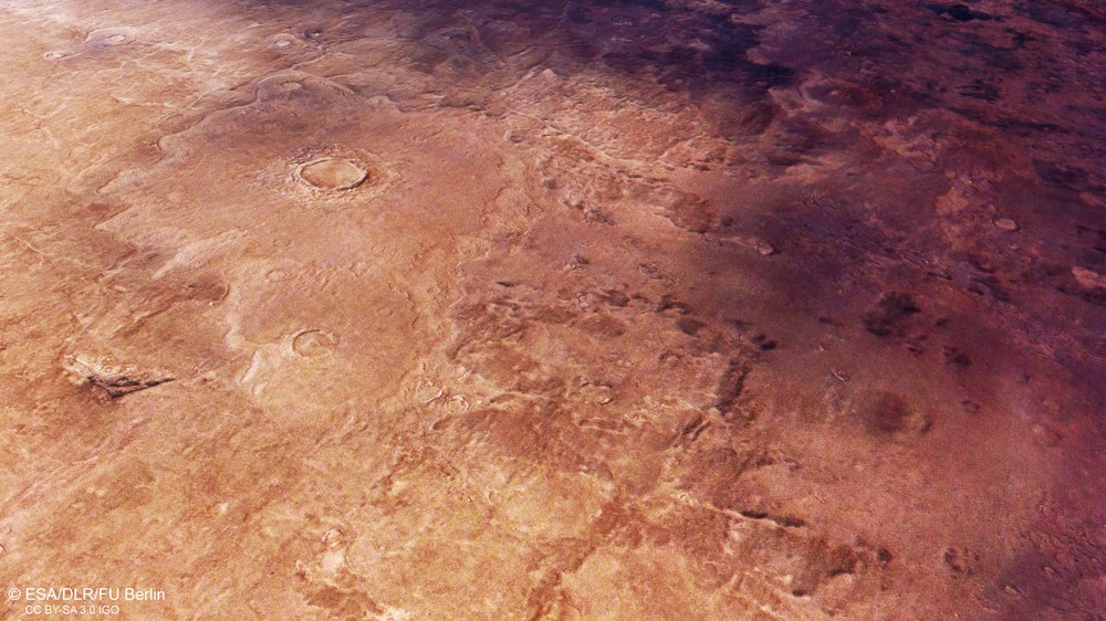
View of two smaller craters in the large Utopia Planitia impact basin on Mars. Their ejecta blankets have a specific form indicating the presence of subsurface ice at the time of the impact.
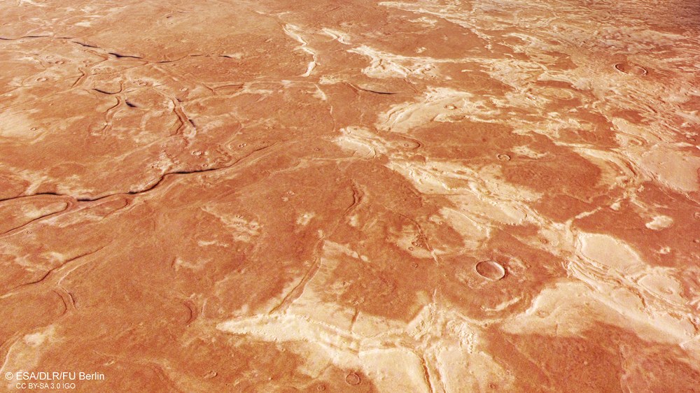
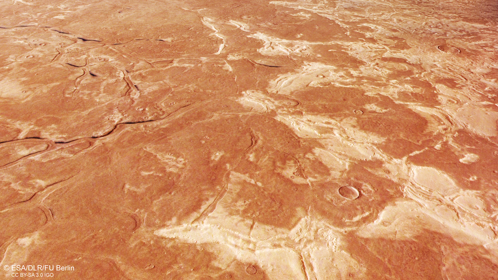
Branched graben structures: evidence of a former ocean?
Depressions up to two kilometres wide and 20 kilometres long intersect, forming a polygonal pattern. The origin of these grabens is complex and possibly indicates they were formed under water. This suggests that the northern lowlands, including Utopia Planitia, may have hosted a standing body of water – possibly even an ocean – early in Mars’s history.
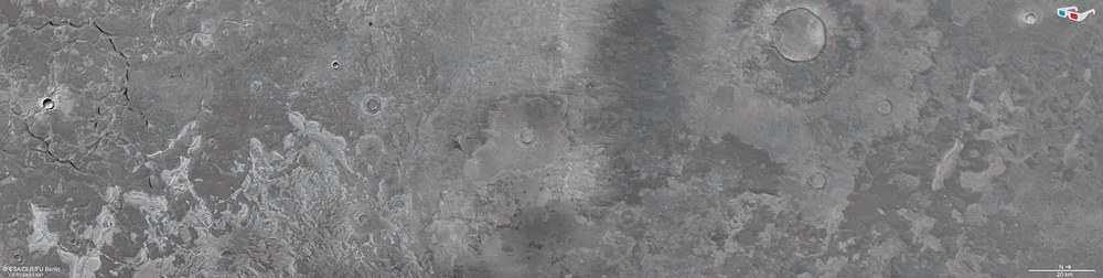
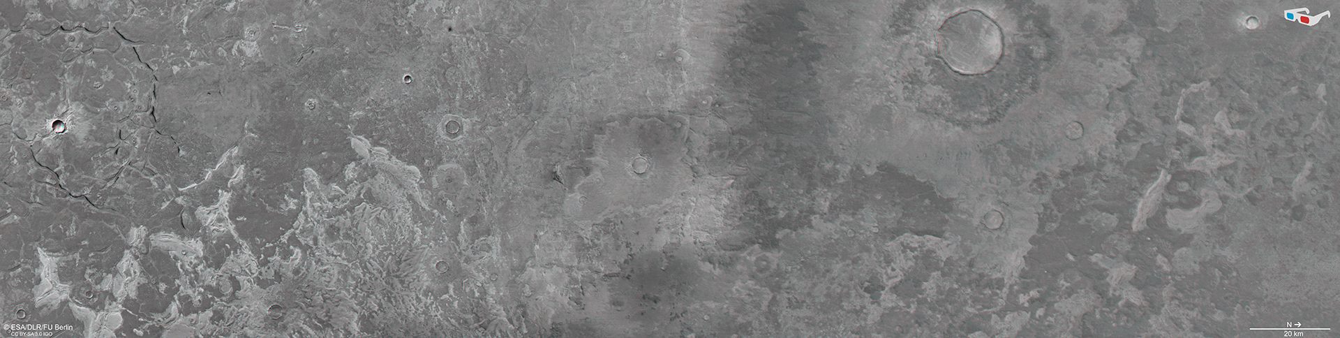
3D (anaglyph) image of a section of Utopia Planitia
Using the nadir channel, which is directed perpendicular to the Martian surface, and one of the oblique stereo channels of the HRSC camera, anaglyph images can be generated. When viewed with red-blue or red-green glasses, they provide a three-dimensional view of the landscape. The high resolution of 17 metres per pixel allows even the smallest topographic features to be visualised.
Images from the German HRSC stereo camera show part of the 3300-kilometre-wide Utopia Planitia impact basin on Mars.
Numerous land features here point to a very large deposit of subsurface water ice.
HRSC images are used to depict and study a landscape typical of the region, with its diverse characteristics.
HRSC is a camera experiment developed by DLR and carried on board the European Mars Express mission. Since January 2004, HRSC has been reliably sending images of Mars back to Earth.
Focus: Spaceflight, exploration, Mars
The vast Utopia Planitia impact basin lies in the northern hemisphere of Mars. Considerable quantities of water ice lie beneath the surface here, making it of great interest to Mars research. New images from DLR's High Resolution Stereo Camera (HRSC) orbiting Mars reveal a particularly large number of typical landforms that indicate the presence of such subsurface ice deposits. HRSC is a camera experiment on board the Mars Express spacecraft, developed by the German Aerospace Center (Deutsches Zentrum für Luft- und Raumfahrt; DLR) and operational since 2004.
The icy expanse of Utopia Planitia
With a diameter of approximately 3300 kilometres, Utopia Planitia is one of the three largest impact basins on Mars. It is believed to have formed approximately four billion years ago from an asteroid impact. As early as 1976, NASA's Viking 2 lander discovered that the lowlands in this region exhibit a variety of surface features also found in landscapes on Earth shaped by frost-driven processes. These are known as periglacial landforms. These formations suggest the presence of a large reservoir of ice beneath the Martian surface, which was confirmed in 2008 by the Phoenix lander through excavations and spectral measurements.
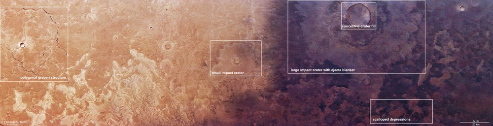
Landscape features in Utopia Planitia
The annotations on this HRSC Mars camera image highlight special features in this region. On the left, branched depressions form a polygonal pattern (polygonal graben structure), possibly created under water. In the centre, a small impact crater (small impact crater) is framed, which, like the large crater (large impact crater with ejecta) in the top right, has a characteristic ejecta blanket indicating subsurface ice. Additionally, the large crater shows concentric crater fill, also suggesting ice, this time in the form of glaciers. In the lower box, scalloped depressions are visible – another typical landform of periglacial regions.
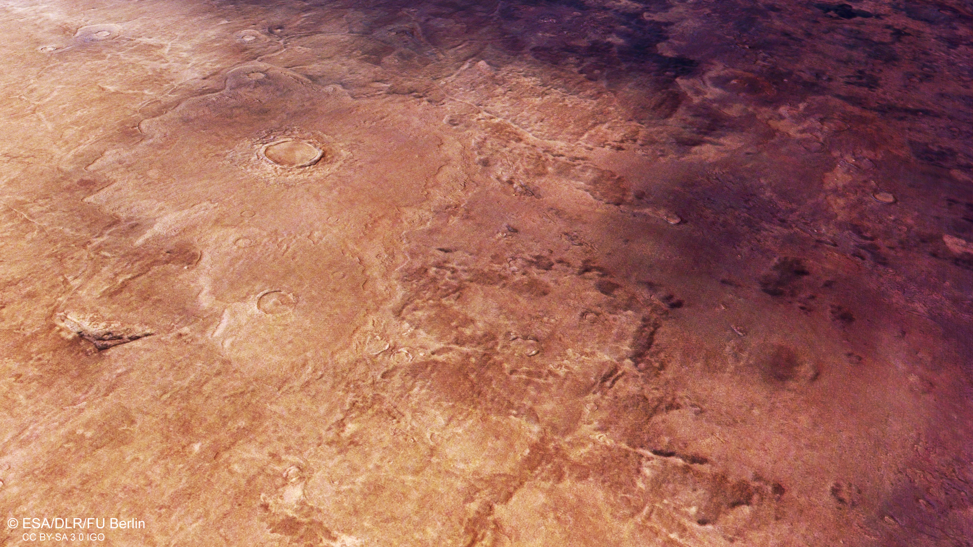
The first typical landform suggesting the presence of subsurface ice is located in the right half of the image (see annotated image). Here, an impact crater approximately 15 kilometres in diameter can be seen with a distinctive ejecta blanket. During the impact, subsurface material was ejected and deposited around the crater. The layered appearance of the eject suggests that subsurface ice melted during the impact and mixed with the rock masses to form a kind of mudflow. Such semi-liquid ejecta typically create the lobe-shaped deposits visible here and at smaller impact craters in the region.
The large crater also displays another characteristic feature that points to ice processes: the ring-shaped pattern on its floor known as concentric crater fill. This consists mainly of ice-rich material and resembles block glaciers on Earth. Such glaciers are covered by a layer of debris or rock and move slowly downslope. When these masses of ice and debris collide within the crater floor, they form such concentric patterns.
The ocean hypothesis
The left side of the image shows a striking feature of the Utopia basin: grabens up to two kilometres wide and 20 kilometres long intersect, forming a polygonal pattern. These are also visible in the centre of the image but appear 'faded' and lack the clear boundaries of the grabens on the left. This could be because the depressions were filled with other materials or were not very deep to begin with.
The origin of these grabens is complex and may be linked to the presence of large quantities of water. As part of Mars's northern lowlands, it was long assumed that Utopia Planitia was host to a body of standing water early in the Red Planet's history – possibly a lake or even an ocean. Sediments may have accumulated at the bottom of the water and, over time, been compacted and drained of their own water content by the great weight of the water above. This may have led to the uneven deformation of the sediment layers, facilitating the fracturing of the surface. Alternatively, tectonic processes may have played a role: following the disappearance of the weight of a former ocean, the crust may have risen and fractured, contributing to the formation of the observed graben structures.
On Earth, too, seismic surveys have revealed polygonal graben networks in mud layers beneath oceans in sedimentary basins.
'Scalloped' depressions in a periglacial environment
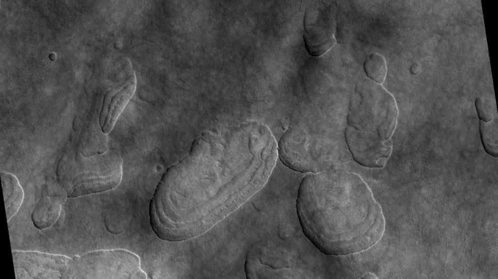
Another typical landform can be seen in the dark area on the right side of the image. Upon closer inspection, numerous depressions are visible which, due to their irregular elliptical outlines and stepped interiors, are known as scalloped depressions. Higher-resolution images (such as data from the HiRISE instrument aboard the Mars Reconnaissance Orbiter) reveal why: the morphology of their edges resembles the shape of scallop shells.
'Scalloped' depressions as indicators of subsurface ice
This close-up from the HiRISE instrument aboard the Mars Reconnaissance Orbiter shows several stepped depressions formed by the disappearance of subsurface ice. Their shape resembles scallop shells, hence the term 'scalloped depressions' in scientific jargon.
Credit:
NASA/JPL/Univ. of Arizona
Scalloped depressions are very common in the mid-latitudes of Mars, where subsurface ice is present, and are interpreted as indicators of periglacial landscapes. They form when ice-rich subsurface material disappears, either through melting or sublimation (the direct transition from the frozen to gaseous state), causing the collapse of the overlying terrain. These depressions do not occur in isolation but merge into larger areas – a perfect example of how the Martian surface is constantly changing.
Dark ash 'wanders' across Mars
Last but not least, the play of colours in the images are also worth noting – bright surfaces on the left give way to dark surface deposits on the right. The surface on the left is covered with the typical reddish Martian regolith (very finely ground material, mostly dust), while the area on the right is covered with volcanic ash and sand deposits, consisting mainly of dark minerals such as olivine and pyroxene.
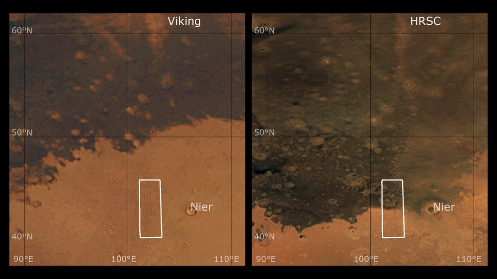
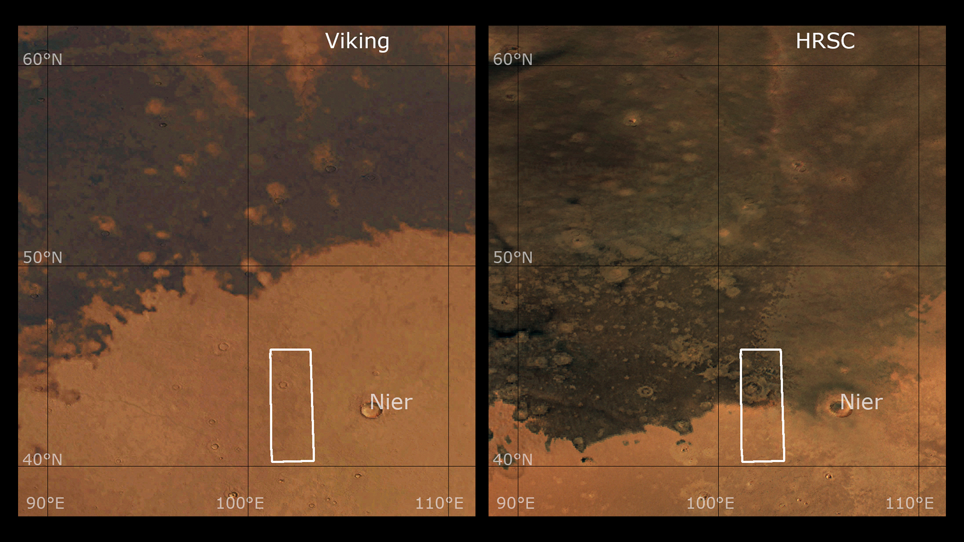
Comparison of ash deposits in a Viking image and the HRSC Mars camera
The left image was taken by the Viking probe in 1976. The right image is from the DLR Mars camera HRSC, taken in 2024. Fifty years ago, the dark volcanic ash and sand deposits were not as extensive as they are today. Over this period, the material must either have been displaced further south by Martian winds, or the red dust that previously covered the ash layer has been blown away.
Credit:
NASA (Image 1) and ESA/DLR/FU Berlin CC BY-SA 3.0 IGO (Image 2)
Interestingly, when the Viking orbiter captured the image on the left in 1976, the dark material did not cover as much of the Martian surface as it does today (HRSC image, right). Over the past 50 years, the dark material must therefore either have been blown further south by Martian winds, or the red dust that once covered the ash layer has been blown away.
Image processing
The images were taken by the HRSC (High Resolution Stereo Camera) on 9 November 2024 during Mars Express orbit 26,327. The ground resolution is approximately 17 metres per pixel, and the image is centred at approximately 43 degrees north and 102 degrees east. The colour image was created using data from the nadir channel, which is aligned perpendicular to the Martian surface, and the colour channels of the HRSC. The oblique views were generated from the digital terrain model, the nadir channel and the colour channels of the HRSC. The anaglyph image, which creates a three-dimensional impression of the landscape when viewed through red-blue or red-green glasses, was derived from the nadir channel and one stereo channel. The colour-coded topographic view is based on a digital terrain model of the region, from which the topography of the landscape can be derived.
The High Resolution Stereo Camera was developed at DLR and built with industry contributors EADS Astrium, Lewicki Microelectronic and Jena-Optronik. The science team, led by Principal Investigator (PI) Daniela Tirsch, comprises 50 co-investigators from 35 institutions and 11 countries. The camera is operated by the DLR Institute of Space Research in Berlin-Adlershof.
