The 'bright secret' of the Trouvelot Crater on Mars
March 4, 2026 | Mars Express mission
The 'bright secret' of the Trouvelot Crater on Mars
Dark sands and bright sediments in Trouvelot Crater on Mars
The 150-kilometre-wide Trouvelot Crater in the highlands of Arabia Terra formed approximately four billion years ago. Since then, it has been altered by various geological processes. Over time, the crater rim has eroded, causing material to slide into the crater. In the background, terraces are visible on the crater rim – the result of massive landslides. Wind carried finely crushed, dark volcanic material into the crater. It is likely that a lake once existed in Trouvelot, in which sediment layers were deposited and transformed into bright minerals. These formed a 20-kilometre-long hill.
Trouvelot Crater in the Mars highlands of Arabia Terra
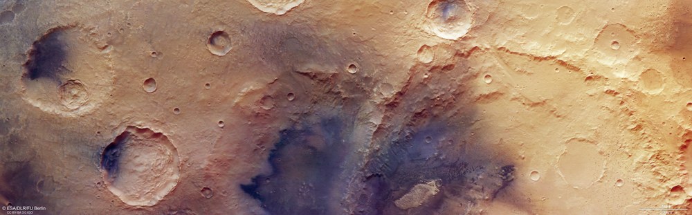
Between the two large outflow valleys of Ares Vallis and Mawrth Vallis lies the highland region of Arabia Terra. One of the oldest landscapes on Mars, it consists of craters formed approximately four billion years ago by impacts from asteroids of varying sizes. The true-colour images from Mars Express show an area of 25,000 square kilometres – nearly the size of Brandenburg. The right half of the image is dominated by the near 150-kilometre-wide Trouvelot Crater, which likely contained a lake in the planet's early history.
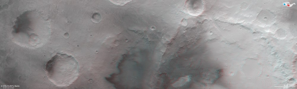
Using the nadir channel (which points vertically at the Martian surface) and one of the oblique stereo channels of the HRSC camera, 'anaglyph' images can be created. When viewed with red-blue or red-green glasses, they provide a three-dimensional view of the landscape. The high image resolution of 18 metres per pixel allows even the smallest topographical features to be visualised, such as the sediment layers of the bright, approximately 20-kilometre-long hill at the bottom of the image or individual crescent dunes in the dark dune fields.
New images from the German HRSC stereo camera show the Trouvelot Crater in the Arabia Terra region of Mars.
Particularly striking are its terraced walls, dark sand dunes and a bright hill at the crater floor.
HRSC is a camera experiment developed by DLR aboard the European Mars Express mission.
Since January 2004, HRSC has reliably sent images of Mars back to Earth.
Using digital terrain models based on HRSC data, researchers are mapping the planet’s landscape topographically and visualising it in three dimensions.
Focus: Spaceflight, exploration, Mars
New images from the German High Resolution Stereo Camera (HRSC) orbiting Mars reveal a striking landscape in the Arabia Terra region. This area is characterised by impacts from asteroids large and small, which have left numerous marks across the landscape. The focus is on the Trouvelot Crater with its dark deposits, dunes and bright rock outcrops – and a bright geological formation that is rather unusual for Mars.
HRSC is a camera experiment developed by the German Aerospace Center (Deutsches Zentrum für Luft- und Raumfahrt; DLR) for the ESA Mars Express mission and has been sending images of Mars back to Earth since January 2004. Digital terrain models derived from this image data enable topographical mapping of the planet and three-dimensional visualisation of the Martian landscape. By precisely measuring surface features using this data, scientists can reconstruct geological processes from the early history of Mars in terms of their nature and chronology. On the dynamically changing Earth, such insight into the early history of the planet is no longer possible.
Named after an astronomy pioneer
Arabia Terra lies between two large outflow channels – Mawrth Vallis to the north and Ares Vallis to the southwest. Mawrth Vallis, with its numerous twists and turns, is particularly known for its diverse mineralogy, including sulphates and clay minerals formed under the influence of water.
The most striking feature in the area is the Trouvelot Crater (see annotated image). At an impressive 149 kilometres wide, it is large enough to accommodate the entire Ore Mountains, which lie along the German–Czech border, across its diameter. Three other large craters and a number of smaller impact craters are located in the immediate vicinity. Trouvelot is named after the French illustrator and astronomer Étienne Léopold Trouvelot (1827–1895) who is renowned for his detailed astronomical drawings and observational sketches, which were far more detailed than the first astronomical photographs of the 19th century. In addition to the Martian crater, a lunar crater is also named after him.
Landscape features in Trouvelot Crater and its surroundings
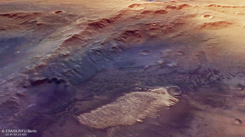
In the highlands of Arabia Terra, where Trouvelot Crater is located (right half of the image), interesting geological phenomena can be observed. Notable are the extensive dark deposits, which consist of sands from crushed volcanic deposits and ash that the wind has piled into large dune fields ('barchan', or crescent-shaped dunes). A heavily eroded crater rim indicates that the impact creating this crater must have occurred earlier than the Trouvelot impact. This is also evident from the fact that Trouvelot's crater rim is much more pronounced and sharp-edged. Rock masses that have slid down from here form extensive terraces (terraced wall) above the floor. Particularly striking are the bright sediments that have accumulated in a 20-kilometre-long and 270-metre-high hill in the middle of the crater (light-toned mound).
Weathered crater rims reveal the age of the region
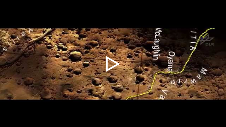
In the 2015 film, astronaut Mark Watney races against time to reach a rocket 'parked' in the Schiaparelli Crater to return to Earth. His journey takes him from Chryse Planitia to Arabia Terra, passing Trouvelot Crater. This animation was created as part of a global, high-precision topographic Mars mapping project with significant involvement from DLR.
The real journey of the 'Martian' – video from images taken by the Mars Express spacecraft (2D)
Your consent to the storage of data ('cookies') is required for the playback of this video on Youtube.com. You can view and change your current data storage settings at any time under privacy.
The real journey of the 'Martian' – video from images taken by the Mars Express spacecraft (2D)
In the 2015 film, astronaut Mark Watney races against time to reach a rocket 'parked' in the Schiaparelli Crater to return to Earth. His journey takes him from Chryse Planitia to Arabia Terra, passing Trouvelot Crater. This animation was created as part of a global, high-precision topographic Mars mapping project with significant involvement from DLR.
The multitude of craters in this region reflects the great age of Arabia Terra – dating back 3.7 to 4.1 billion years. This is evident from the heavily weathered rims of Trouvelot and its neighbours. Due to erosion over time, they appear heavily fissured and wrinkled. The rim of Trouvelot's 'neighbour' is barely recognisable – an indication that it is the oldest of the four large craters in this image. Another sign of Trouvelot's antiquity is its terraced wall. Such stepped structures form when the walls of craters more than 100 kilometres in diameter become unstable over time. They collapse under their own weight, and the material that slides down along the inner slope forms terraces above the crater floor.
A closer look at Trouvelot reveals that its floor is covered with sand dunes composed of dark material. These sands are rich in 'mafic' minerals. They are of volcanic origin with high magnesium and iron content and may derive from thick layers of ancient volcanic ash. Over long geological periods, this ash could have been covered and buried by other deposits, protecting them from surface weathering by water. Later impacts may have cut into this buried layer, re-exposing the dark material along the crater wall. Winds then piled it into countless dunes, mostly within impact craters. Some of the dark sands on Mars may also have formed through the mechanical fragmentation of basaltic lava deposits.
An unsolved mystery
Particularly striking is a bright hill on the floor of Trouvelot, with a ridged and furrowed surface. Approximately 20 kilometres long and 270 metres high, it belongs to the 'equatorial layered deposits' that occur in other craters in this region. Bright sedimentary mounds of this kind are often associated with minerals formed in the presence of water. They are significantly brighter than their surroundings, meaning they have a higher reflectance – known in technical terms as albedo. Spectroscopic studies indicate that these deposits consist mainly of clay and sulphur-bearing minerals.
Bright mineral deposits in the Trouvelot Crater on Mars
This strikingly bright, unusual geological formation is found on the floor of the 150-kilometre-wide Trouvelot Crater in the Arabia Terra highlands of Mars. It is approximately 20 kilometres long, up to eight kilometres wide, and roughly 270 metres high. There, in an aqueous environment, volcanic materials (such as large amounts of ash) may have been deposited in a crater lake and transformed into clay and sulphur-bearing minerals. Later, the layered deposits were eroded by the wind. The exact origin of these sedimentary hills is not yet fully clarified.
Both mineral groups form through weathering processes involving water, making their origin of particular scientific interest. Theories suggest that the bright mounds may have formed from sediments laid down in former crater lakes. After the water disappeared, wind erosion carved numerous furrows into the surface of the layered deposits. A similar, though larger and higher, bright mound is located in the Becquerel crater, approximately 300 kilometres northeast of Trouvelot. Many comparable sedimentary structures are also found in the Valles Marineris canyon system. Deciphering their origin remains an active and complex topic of research.
Image processing
The images were taken by the HRSC (High Resolution Stereo Camera) on 12 October 2024 during Mars Express orbit 26,233. The ground resolution is approximately 18 metres per pixel, and the image is centred at approximately 15 degrees north and 255 degrees east.
The colour image was created using data from the nadir channel, with the field of view oriented perpendicular to the Martian surface, together with the colour channels of the HRSC.
The oblique perspective view was generated from the digital terrain model and data from the nadir and colour channels.
The anaglyph image, which provides a three-dimensional impression of the landscape when viewed with red-blue or red-green glasses, was derived from the nadir channel and one stereo channel.
The colour-coded view is based on a digital terrain model of the region, from which the topography of the landscape can be derived.
The High Resolution Stereo Camera (HRSC) was developed at the German Aerospace Center (DLR) and built in cooperation with industry (EADS Astrium, Lewicki Microelectronic GmbH and Jena-Optronik GmbH). The science team, led by Principal Investigator (PI) Daniela Tirsch, consists of 50 co-investigators from 35 institutions and 11 nations. The camera is operated by the DLR Institute of Space Research (formerly DLR Institute of Planetary Research) in Berlin-Adlershof.


