Brochure: Earth Observation (2013)
10.7 MB | PDF
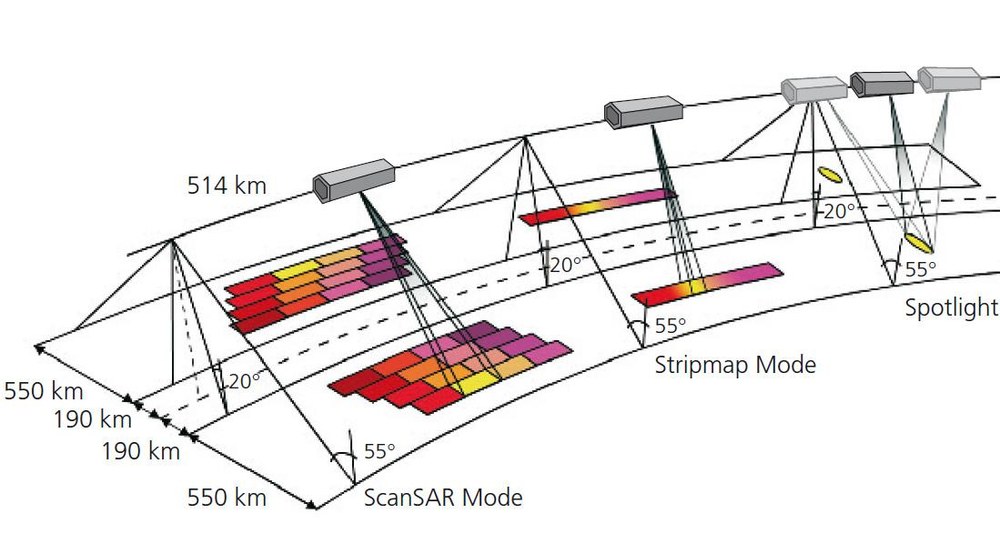

Radars operating at microwave frequencies are capable of imaging Earth’s surface independently of the weather and local time of day. For this purpose, both TanDEM-X and TerraSAR-X use an active antenna consisting of an array of transmit-and-receive modules designed for rapid changes in the direction of the radar beam as well as programmable antenna characteristics. Electromagnetic wave polarisation and other radar parameters may even be varied from one pulse to the next. All this makes synthetic aperture radar technology flexible enough to be used for testing innovative, experimental operating modes.
The routing of the radar transmit-and-receive signals permits separating the two halves of each antenna electrically in the direction of flight and, consequently, separating radar signal reception by each half of the antenna. This facilitates gathering fully polarimetric data for classifying objects such as houses or trees, as well as along-track interferometry. Moreover, the architecture permits routing of calibration signals through the entire radar hardware chain except for the radiating waveguides, which consist of metallised carbon-fibre reinforced plastic for inherent stability. The calibration signals are used to determine correction factors for optimising the stability of measurement data when they are processed on the ground.
The solid-state mass memory on TanDEM-X has a capacity of 768 gigabits, to cope with the enormous amount of data for the digital elevation model. This is twice the memory capacity of TerraSAR-X. In the last phase of the development of TerraSAR-X, the design of the synthetic aperture radar instrument was modified to permit the continuous exchange of synchronisation pulses in order to ensure the consistent operation of the two synthetic aperture radars in bistatic mode.
It is possible to operate TanDEM-X independently (monostatic mode) as well as in sync with TerraSAR-X (for example, in bistatic mode). Operational digital elevation model generation is planned to be performed using bistatic interferometry, which is characterised by the illumination of a scene by one transmitter and the simultaneous measurement of the same scene with two receivers. This avoids temporal variations of the ground surface characteristics between measurements, which would reduce the achievable height measurement performance. In the bistatic mode the TanDEM-X interferometer is operated with two independent oscillators. Uncompensated oscillator noise will cause substantial interferometric phase, and consequently height, errors. To correct for these phase errors and also to enable synchronisation between the two synthetic aperture radar sensors, the TanDEM-X-specific synthetic aperture radar instrument features provide a scheme for exchanging synchronisation information through a dedicated link. This comprises a set of six horn antennas, optimally distributed to ensure full solid-angle coverage with low phase disturbance. The communication consists of a periodic exchange of synchronisation chirp pulses that are compressed as normal synthetic aperture radar pulses and provide, after proper evaluation, the differential phase behaviour of the satellite oscillators. This enables the phase correction of the interferometric system in the on-ground processing chain.
Conventional radar satellites operate using the principle of synthetic aperture radar. The radar transmits pulses of microwave energy and these are reflected from Earth's surface to be received again by the radar. The distance of the satellite from Earth’s surface can be calculated from the round-trip transit time of the signals. As the satellite orbits Earth, the radar illuminates a strip of ground beneath it and records the reflected signals sequentially. After intensive signal processing a two-dimensional image of the area is generated. The received echo signals also contain information about the properties of the reflecting surface, such as its roughness.
Synthetic aperture radar interferometry is a further development of this basic technique. The target land area is imaged from two different positions. The principle is similar to human stereoscopic vision, where depth perception – determining the distance of an object from the viewer – is achieved by viewing the object from slightly different angles with a pair of eyes. The ‘radar eyes’ are located on the satellites TerraSAR-X and TanDEM-X, which are orbiting Earth in close formation.
Because the satellites are a set distance or 'baseline' apart each other, the 'path length' that the signal travels as it is reflected back from each point on the ground will differ slightly for each of them – and by measuring these differences precisely enough, elevation information can be derived. This is done by using the wave properties of the radar pulse and examining the relative time shifting of the waves due to the differing path lengths. This is also called 'phase difference measurement'. The result of performing these measurements for each point over an area of Earth’s surface is an interference pattern called an interferogram. From the measured differences in path length, the desired height information is obtained, with interference 'fringes' that resemble contour lines on a conventional map.