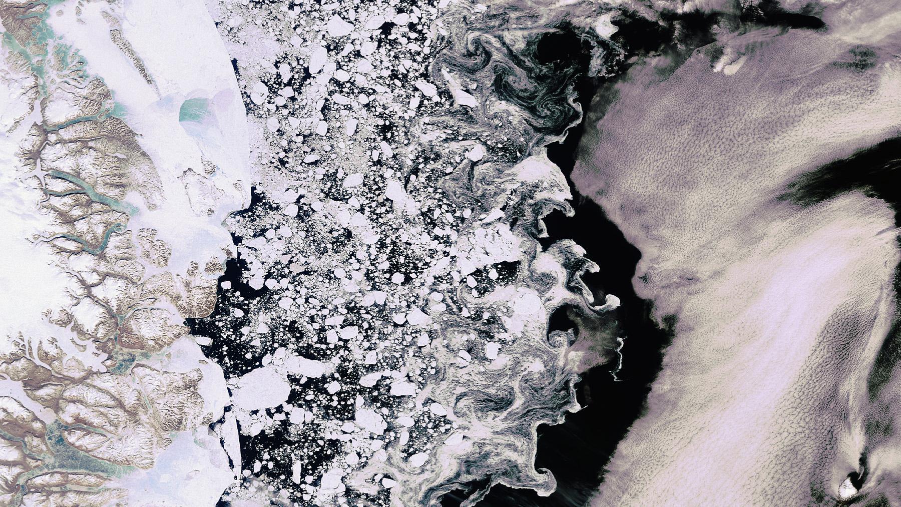
The image shows ice floes in the Greenland sea that drift southwards during the spring thaw. Reliable sea-ice services are required in order to safely navigate polar waters.
3-D model of the seabed in the North German Bight; here, different depths are displayed by colour. The analyses are based on images acquired by Landsat 8 in 2013.
Modern Earth observation satellites, such as the Sentinels from the European Copernicus programme, provide highly accurate and up-to-date data that can also be used for commercial services.
New satellite-based services for increased safety and efficiency in shipping
A new corporate network will ensure increased safety and lower costs in the field of maritime traffic in future. Five private companies and a research institute are now working together within the MARSAT project to develop new services for the maritime industry using satellite data. Among these are, for example, the optimisation of shipping routes, day-to-day sea-ice services, and mapping of the seabed. Alongside shipping, the offshore industry and emergency and rescue services will also benefit from the new services.
Modern Earth observation satellites enable near real-time services
"The latest generation of Earth observation satellites, such as the Sentinels from the European Copernicus programme, enable highly precise imaging to be carried out at frequent intervals," explains Michael Nyenhuis, project manager at the DLR Space Administration. "In this way, ongoing environmental changes and timely ship positions can be accurately detected." This enables MARSAT to develop new near real-time services for the planning of shipping routes in the polar region, for example. These are able to display the up-to-date development of pack ice and information regarding sea conditions, thereby increasing the safety of ship passages. Sensitive marine ecosystems will also benefit from these accident-preventative measures. Furthermore, shipping companies can better calculate risk: In the case of a low risk potential, ships can choose the direct route instead of making long detours around the region, saving both time and money.
Alongside shipping companies, ports are also potential users of the services: On the one hand, satellite data allows the position of ships to be determined with pinpoint accuracy and integrated into modern pilot services. This makes traffic routing easier and therefore also enhances safety in moorings. Information services regarding water condition, water depth mapping and seabed mapping, on the other hand, offer important foundations for maritime industry planning, such as for the establishment and operation of offshore wind farms. Important information for emergency and relief services can also be obtained from satellite data. In this way, objects such as life rafts and lifeboats, as well as containers can be detected following an accident and their position communicated.
Numerous satellites are to be used by the MARSAT services – among them, optical systems such as Sentinel-2, Sentinel-3 and Landsat 8, as well as radar systems such as Sentinel-1 that can also operate at night and regardless of cloud cover. Commercial satellites with the highest spatial resolution sensors GeoEye-1 and WorldView-1 to -4 and radar data from TerraSAR-X and TanDEM-X will also be used.
MARSAT project partners include EOMAP GmbH & Co. KG in Seefeld, Drift & Noise Polar Services GmbH in Bremen, European Space Imaging GmbH (EUSI) in Munich, SevenCs GmbH in Hamburg, and TRENZ AG in Bremen, as well as the Institute of Shipping Economics and Logistics (ISL) in Bremerhaven. This association will see small and medium-sized enterprises and a research institute combine their extensive experience and expertise in the field of satellite services, software development, and maritime services and call on the infrastructure of project partners that is already available – for example, to receive and process data. Following the development stage, the services will be integrated into existing applications within the maritime industry – in pilot or port services, for example – and implemented and tested in collaboration with users. MARSAT is being financed and coordinated by the DLR Space Administration with funding from the German Federal Ministry for Economic Affairs and Energy (BMWi).


