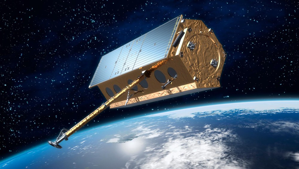
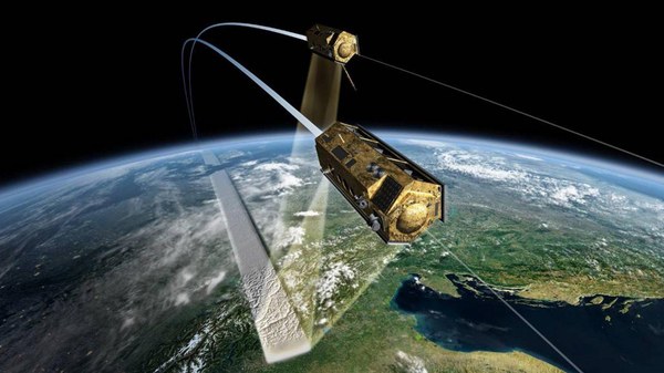
TerraSAR-X orbits the Earth at an altitude of 514 kilometers in a polar orbit. With its active antenna, it acquires novel and high-quality X-band radar data from all over the Earth. TerraSAR-X operates independently of weather conditions, cloud cover and daylight and is able to provide radar data with a resolution of up to one meter.
TerraSAR-X is a German Earth-observation satellite. Its primary payload is an X-band radar sensor with a range of different modes of operation, allowing it to acquire images with different swath widths, resolutions and polarisations. TerraSAR-X thus offers space-based observation capabilities that were previously unavailable. The objective of the mission is to provide value-added SAR (Synthetic Aperture Radar) data in the X-band, for research and development purposes as well as scientific and commercial applications.
The successful launch of TerraSAR-X on 15 June 2007 at 08:14 local time from the Russian Baikonur Cosmodrome in Kazakhstan marked the start of a campaign to map the Earth at an unprecedented level of accuracy. Since then new and high-quality radar images of the Earth's surface have been created.
Night and overcast conditions are no problem for TerraSAR-X
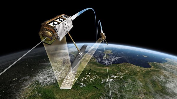
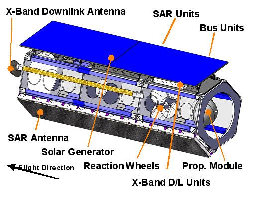
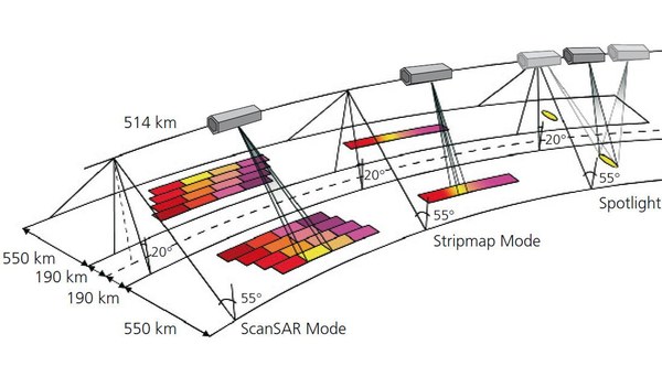
The satellite is in a near-polar orbit around the Earth, at an altitude of 514 kilometres. Using its active radar antenna, it is able to produce image data with a resolution of down to one metre, regardless of weather conditions, cloud cover or absence of daylight. Every part of this satellite was built in a very compact way. It has a five meter long body with hexagonal cross-section carrying an active radar system as its primary payload. The radar beam can be electronically steered within a range of 20 to 60 degrees perpendicular to the flight direction, without having to move the satellite itself. The advantage is obvious: The desired area can be targeted without time delay and a denser sequence of images is possible than with fixed beam radar that requires mechanical alignment. Since 2010, it has been followed by the almost identical TanDEM-X satellite, which, in addition to the TanDEM-X mission, also carries out conventional SAR images and thus makes an additional contribution to the TerraSAR-X mission.
Public-private partnership
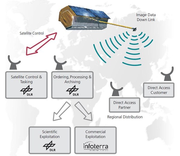
TerraSAR-X was realised on behalf of the German Aerospace Center (DLR) with funds from the Federal Ministry of Economics and Energy. It is the first German satellite to be realised as part of a public-private partnership (PPP) between DLR and Airbus Defence and Space (formerly Astrium): The use of TerraSAR-X data for scientific purposes is the responsibility of DLR, which is also responsible for the conception and execution of the mission as well as satellite control (all available data can be searched online by registered users in the DLR catalogue EOWEB – see link in right-hand column; scientists can submit project proposals to DLR and receive data under COFUR conditions (Cost Of Fulfilling User Request). Airbus Defence and Space contributes to the costs for the development, construction and operation of the satellite. The programme line 'Geo-Intelligence' is responsible for the commercial marketing of the data. Since 2016, the project has been carried out on under a continuation agreement with Airbus.
Germany – world leader in Earth observation
With TerraSAR-X, techniques and knowledge gained from earlier radar missions are expanded and systematic long-term observations are carried out. For example, the observation of vegetation is of outstanding importance for human life. Precise and up-to-date information on the distribution, composition and alteration of vegetation species is the basis for many applications. One of the outstanding features of TerraSAR-X is its high spatial resolution, which has never before been achieved by a civil radar system. This enables scientists to include detailed soil characteristics, such as the differentiation of different crops, for better classification.
TerraSAR-X at a glance:
Length:
4.88 metres
Diameter:
2.4 metres
Launch mass:
1,230 kilograms
Payload mass:
about 400 kilograms
Radar frequency:
9.65 Gigahertz
Power consumption:
800 watts (on average)
Resolution:
1 metre, 3 metres, or 16 metres (depending on the image size)
Launch vehicle:
Dnepr 1 (converted SS-18)
Launch date:
15 June 2007, 4:14 CEST
Launch site:
Baikonur, Kazakhstan
Orbital altitude:
514 kilometres
Angle of inclination with respect to the equator:
97.4 degrees (Sun synchronous)
Mission life time:
at least 5 years
The DLR Microwaves and Radar Institute (DLR-Institut für Hochfrequenztechnik und Radarsysteme), the DLR Remote Sensing Technology Institute (DLR-Institut für Methodik der Fernerkundung) and the German Remote Sensing Data Center (Deutsches Fernerkundungsdatenzentrum; DFD) of DLR cooperate closely in the 'SAR Center of Excellence'. The partner institutions complement each other by covering all relevant fields, from sensor technology and mission design to high-precision operational processing and value-added end-user products. Together with DLR's German Space Operations Center (Deutsches Raumfahrt-Kontrollzentrum), these institutes are also responsible for building the TerraSAR-X ground segment as well as operating the satellite over a period of five years.
News
Loading
Multimedia
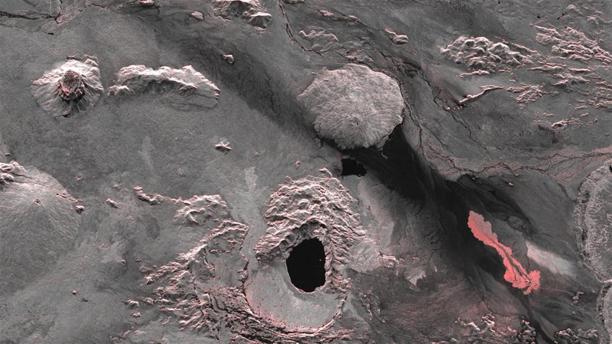
Lava eruption in the Holuhraun lava field, 40 kilometres north of the central volcano Bardarbunga
Holuhraun is a lava field in Iceland’s highlands, north of Vatnajökull glacier; it is part of the Bardarbunga volcanic system. In this image, acquired by the German radar satellite TerraSAR-X, the freshly exposed lava can easily be seen in the right-hand part of the picture. The lighter areas in the image, which have been coloured red to enhance their visibility, show a variation in amplitude – the intensity of the radar signal that comes back to the satellite. The rough surface of the freshly cooled lava reflects the radar signals very strongly, and thus appears bright. Smooth surfaces such as water reflect the incident radar beam away from the satellite and therefore appear dark in the image, like the crater of the Askja volcano in the lower centre of the image.
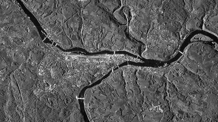
The team of the Center for Satellite Based Crisis Information (ZKI) of the German Aerospace Center (DLR) evaluates the images of the German radar satellite TerraSAR-X for maps of the flooded city of Passau.
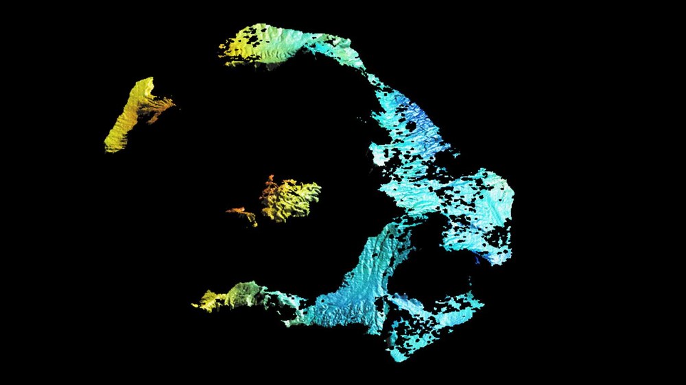
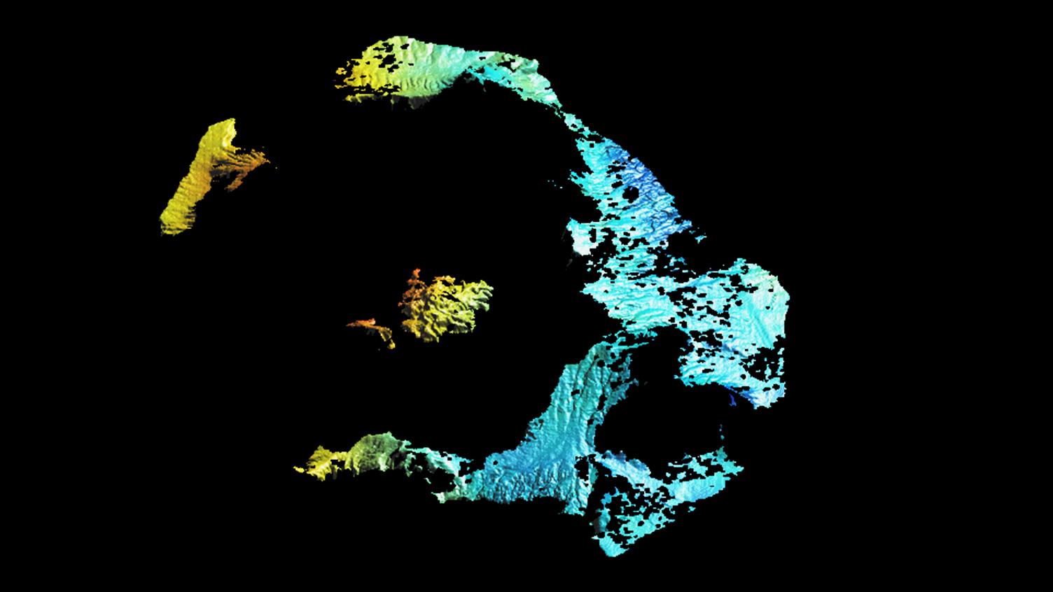
British researchers have used images acquired by the German Aerospace Center (Deutsches Zentrum für Luft- und Raumfahrt; DLR) TerraSAR-X satellite to create a map showing changes in the Santorini archipelago. The cause of the deformation is the Santorini volcano located beneath the archipelago. In some places, the Kameni Islands inside the flooded caldera have risen by eight to 14 centimetres. The breadth of the caldera as a whole has increased by about 14 centimetres since early 2011. In the analysis of the radar data, the red and yellow shading shows the areas where the ground has risen the most. The main island of Thira is unaffected by the deformation, thus appearing blue.


