Brochure: TerraSAR-X (2009)
9.0 MB | PDF
The German Radar Eye in Space

In order to represent ground objects that are, one metre apart as separate pixels in an image, a radar sensor needs to have a resolution of one metre or better. To achieve this performance, TerraSAR-X would need an antenna of at least 15 kilometres in length.
As the antenna is in fact only about five metres long, a special technique is used to achieve the desired result. This technique makes use of the fact that the antenna moves past the illuminated objects along the satellite’s orbit, emitting pulses at regular intervals and capturing the echoes. The echoes are first digitalised and stored on board the satellite. The recorded data is then transmitted to the DLR ground station at Neustrelitz, where the signals undergo extensive computer processing in which they are treated as if they originated from a large number of separate TerraSAR-X antennas distributed along the satellite’s orbital path. Through this computational process, known as 'aperture synthesis', the virtual separate antennas are linked together to form a large 'synthetic' antenna of up to 15 kilometres in length. The effect is then exactly the same as it would have been if a long antenna had really been used.
The term 'aperture' (from the Latin 'apertus', meaning 'open' or 'opened') is used in optics to denote the opening through which light enters or exits an optical system. In the case of a radar system, it refers to the antenna face capable of transmitting or receiving electromagnetic waves. The geometric resolution that can be achieved is inversely proportional to the size of the aperture.
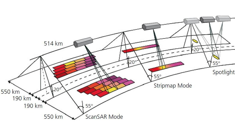
As microwaves can pass through clouds, radar sensors have the added advantage of being able to deliver image data regardless of weather conditions and the availability of daylight. TerraSAR-X's 384 individually controlled transmit/receive modules allow the radar beam to be swivelled and shaped without any time delay. This enables the satellite to target specific areas and to switch between large-scale images with a resolution of 16 metres and small-scale images with a resolution of down to one metre.
The sensor operates in the X-band and in three different modes:
If two antennas separated by a fixed distance are used, each of these is located at a slightly different distance from a given point on the ground. From the difference between these two distances, the elevation of the observed point above a reference plane can be calculated. A digital elevation model can be created by doing this for a large number of points. The difference in distance is determined by measuring the time difference between the arrivals of the radar echoes. The accuracy of the elevation measurements can be improved significantly (to sub-centimetre level) by also analysing the phase differences between the backscattered signals.
This technique, known as radar interferometry, especially when combined with TerraSAR-X's high geometric resolution of about one metre, opens up a range of new applications. Since TerraSAR-X only has one antenna, two passages in slightly different orbits are required in order to obtain a perspective view of the Earth. There is a drawback to using two images recorded at a fixed interval apart to determine elevation: any changes that take place at the Earth's surface during this interval (such as rainfall or plant growth) can lead to inaccuracies. The TanDEM-X project however will bypass this limitation by flying TerraSAR-X in close formation with a practically identical second satellite. As the maximum distance between the satellites is 600 metres, two images are recorded with a maximum time lag of 0.08 seconds – almost simultaneously. This means that the accuracy of the digital elevation model no longer depends on any changes that could occur over time.