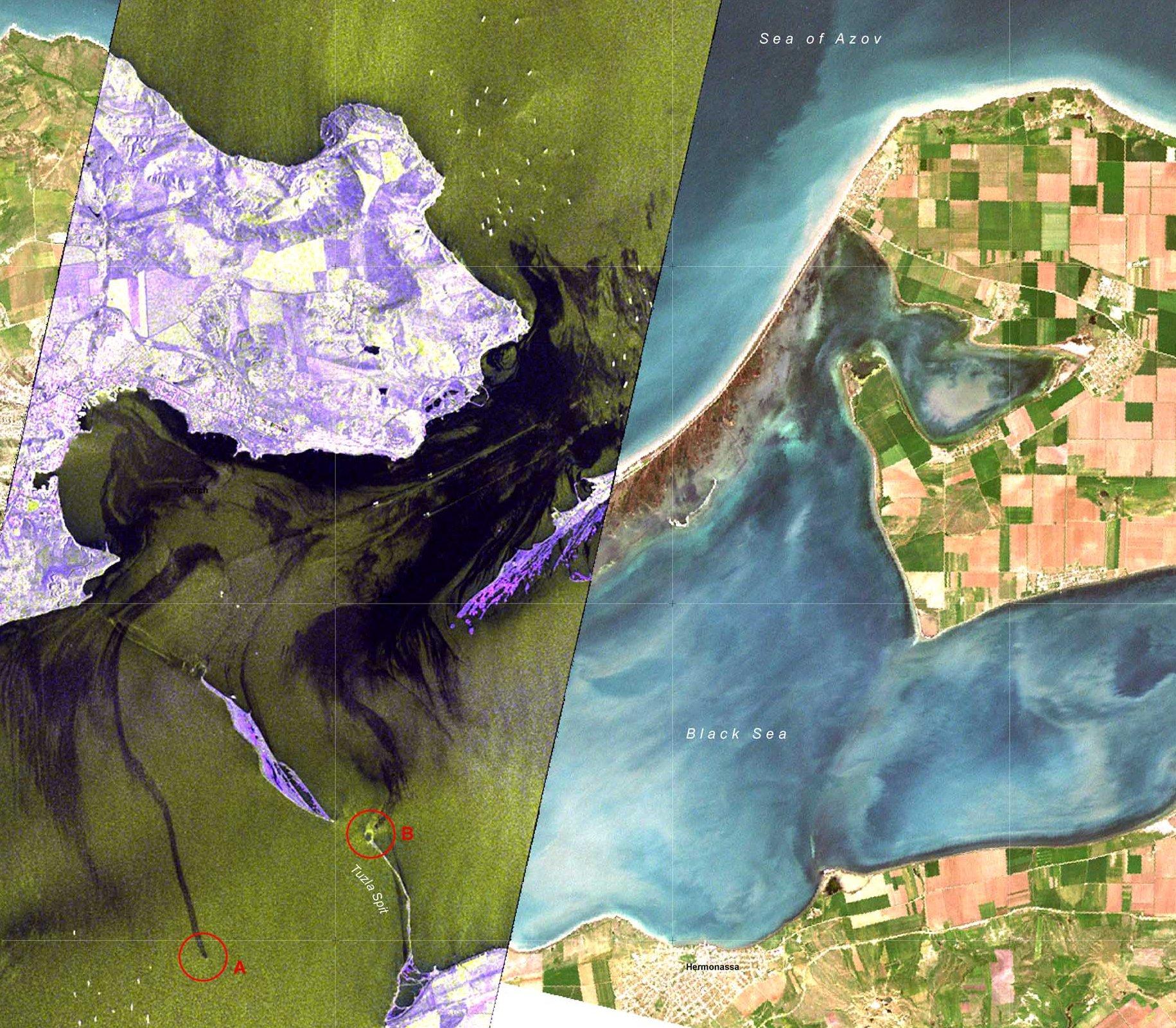
On the 11 November 2007, a storm broke the Russian tanker Volgoneft-139 apart. This TerraSAR-X image shows the oil slick in the Kerch Strait between the Ukraine and Russia. The image covers an area of approximately 30 by 100 kilometres in both polarisations (VV and HH).
Due to its variety of operating modes, TerraSAR-X data can be used both for established applications of high-resolution data and also for large-scale monitoring tasks. The link list on the right of this page contains recent publications concerning the scientific exploitation and application of TerraSAR-X data.
Land use and regional/urban planning
So far, radar data have been effectively applied to forest monitoring, the investigation of the global carbon cycle and compliance verification for international climate conventions. The outstanding spatial resolution of the TerraSAR-X radar also allows the derivation of meaningful texture parameters. A significant improvement in land-use classification with respect to discrimination between crops and in mapping of humid areas and coastal zones can be expected. The evaluation of cross-polarised and polarimetric X-band SAR data will yield better insight for the disciplines of land-use analysis and environmental monitoring. Recently, advanced algorithms have been developed for the extraction of traffic infrastructure information and for traffic surveillance.
Disaster management
Disaster management comprises risk analysis, constant monitoring of threatened areas, the support of rescue teams and damage assessment. For these applications, the substantial advantage of radar sensors is their ability to operate in all weather conditions and the absence of daylight. Even on the global level, most regions of interest can be mapped by TerraSAR-X within 25 days of the event of interest. By means of repeat-pass interferometry, large-scale movements of and changes to the surface of the Earth can be detected and monitored with an accuracy of centimetres. These changes may be caused by earthquakes, volcanic activity, ground subsidence or landslides. TerraSAR-X data are essential for ‘DLR's Center for satellite based disaster monitoring’ (Zentrum für satellitengestützte Kriseninformation; ZKI).
Snow and glaciers
Apart from its relevance for the understanding of climate change impacts, up-to-date information on snow and ice coverage is important for agriculture, the prediction of flooding and the generation of hydroelectric power. In this domain, new insight is expected from the evaluation of cross-polarised and polarimetric data. These data will also build a solid base for the estimation of the melt-water equivalent and the mapping of ablation and accumulation zones on glaciers.
Sea and sea ice
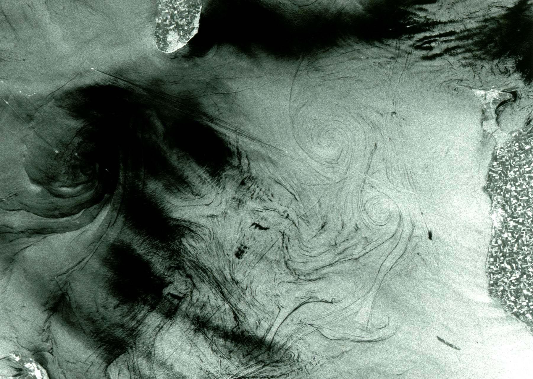
A high image repetition rate is necessary for the monitoring of sea ice and icebergs. With its beam steering capability, TerraSAR-X is able to fulfil this requirement. In addition, the X-band is optimally suited to differentiating between various types of ice. Further improvements will be achieved through the extraction of textural parameters from high resolution TerraSAR-X data. VV-polarised X-band data allow the detection of oil on sea water because of the resulting reduction of surface roughness, which causes increased polarimetric anisotropy or decreased circular coherence of the backscattered signal.


