HALO research aircraft measures emissions from major cities


- Measurements of emissions above London, Rome and the Ruhr region
- Focus on movement and photochemical conversion of emissions
- Including low-altitude flight measurements
- Focus: Aviation, Environment, Air pollution control
Emissions from major cities can spread beyond the limits of these urban areas under certain weather conditions. When this happens, the wind often carries particles and gaseous pollutants over 1000 kilometres. The German Aerospace Center (Deutsches Zentrum für Luft- und Raumfahrt; DLR) is currently carrying out a series of research flights, lasting until until 30 July, to find out more about the distribution and conversion of emissions from London, Rome, the Ruhr region and other European urban areas. Scientific leadership of the international EMeRGe project (Effect of Megacities on the transport and transformation of pollutants on the Regional and Global scales) is the responsibility of the University of Bremen. The aim is to better understand and be able to predict the extent and effects of air pollution from populated areas on Earth's atmosphere.
"In total, 52 flight hours are planned over some of Europe's metropolitan regions by the end of July," says project leader John P. Burrows from the Institute of Environmental Physics at the University of Bremen. "In total, 52 flight hours are planned over some of Europe's metropolitan regions by the end of July," says project leader John P. Burrows from the Institute of Environmental Physics at the University of Bremen. The HALO research aircraft is equipped with a total of 20 instruments to capture the various gas and particle emissions from major cities. "We want to understand in detail how emissions are spatially distributed in the atmosphere under different weather conditions and find out which conversion processes take place that lead to secondary photooxidants and aerosol particles," says Hans Schlager from the DLR Institute of Atmospheric Physics. "For example, we are investigating the formation of ozone from nitrogen oxides, hydrocarbons, particles of sulphur dioxide and organic precursor compounds."
Altitude profile of pollutant distribution
The modern High Altitude and Long Range Research Aircraft (HALO) takes off each time from its home base in Oberpfaffenhofen, near Munich, for measurement flights over various European metropolitan areas. "To give the researchers an accurate picture of the distribution of urban emissions, HALO flies at progressively higher altitudes, initially at around 1000 metres, then climbing to three and then five kilometres," says Frank Probst from the DLR Flight Operations (FB). "In cities such as London or a heavily-populated area such as the Ruhr region, this needs detailed planning and the approval of the relevant local air traffic control authority, as we are carrying out measurement flights in very crowded airspace." Furthermore, as the flights are at relatively low altitudes, they need to be carried out under cloud-free conditions so that the aircraft can fly into the exhaust gas plumes of the cities.
Visual flight at low altitude
The flight segments – which sometimes take place less than a kilometre above the ground, for example over the Po Plain in Italy – are particularly challenging. "In low-level flight, in addition to close coordination with air traffic control, we are reliant upon visual flight," says DLR research pilot Marc Puskeiler. "At this altitude there are a lot of light aircraft and helicopters that we have to look out for to ensure safe operations."
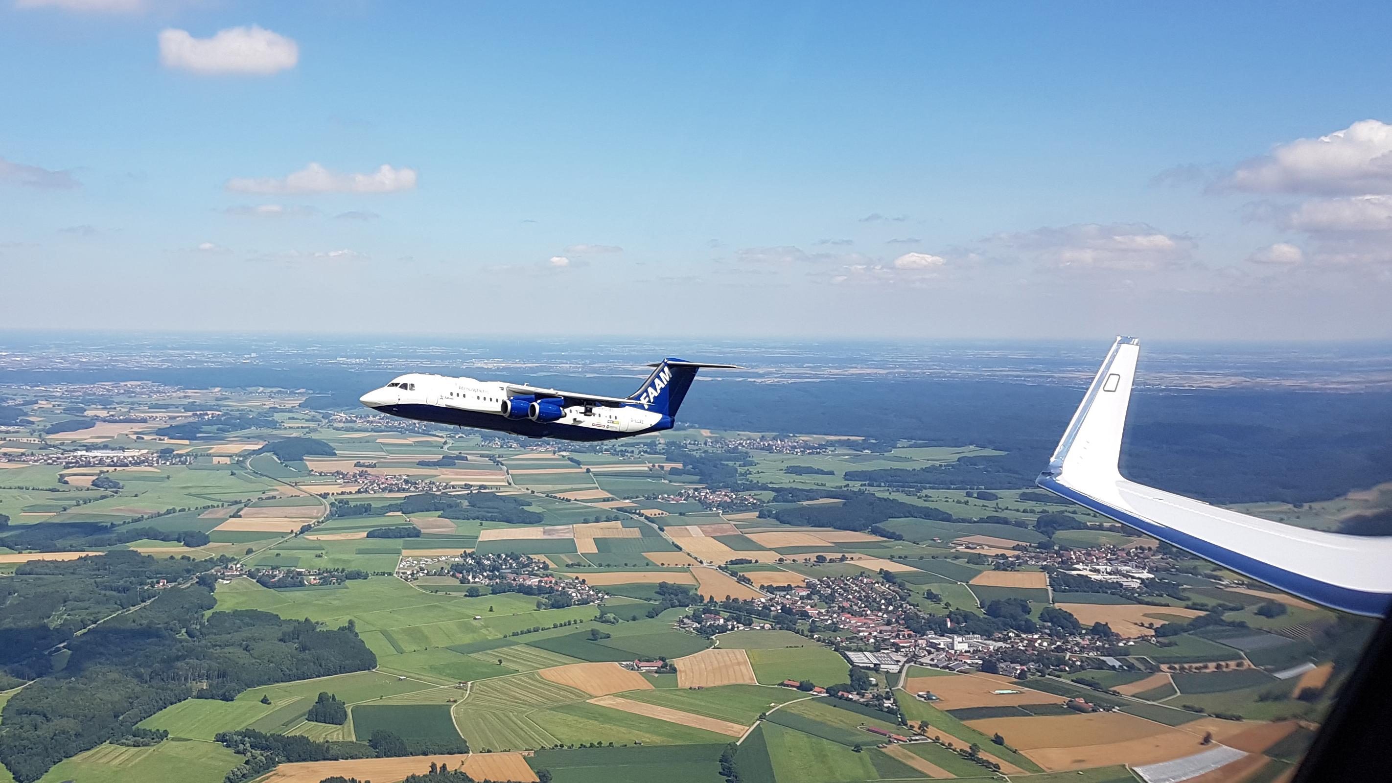
Joint measurement flights over London
On July 17, the researchers carried out a HALO measurement flight into the large-scale pollutant plume over London. This was done jointly with the BAe 146 research aircraft belonging to the British FAAM (Facility for Airborne Atmospheric Measurements) . London is the only European megacity with over 10 million inhabitants. Investigations there are of particular interest for comparisons with HALO measurements in the vicinity of Asian megacities such as Taipei, which are planned for March 2018.
In parallel with the HALO flights, additional measurements using other aircraft are also taking place in Britain and Italy. Furthermore, ground-based measurements and laser-based lidar observations are being used across Europe for planning and assessing the HALO flights. Six HALO measurement flights above Europe are planned up to the end of July. DLR has been providing information via its social media channels on where the flights are taking place.
Project with around six million euros in funds
Other project partners are the Max Planck Institute for Chemistry, the Universities of Mainz, Heidelberg and Wuppertal, as well as the Karlsruhe Institute of Technology and the Jülich Research Center. The project is financed until April 2018 by the German Research Foundation (Deutsche Forschungsgemeinschaft; DFG), the Max Planck Society (Max-Planck-Gesellschaft; MPG) and DLR, with some six million euros.
About HALO
The HALO research aircraft is a joint initiative of German environmental and climate research institutions. HALO was procured with funds from the German Federal Ministry of Education and Research (BMBF), the Helmholtz Association and the Max Planck Society. HALO is operated by the German Research Foundation, the Max Planck Society (MPG), Jülich Research Center (FZJ), Karlsruhe Institute of Technology (KIT), the German Research Centre for Geosciences (Deutsches GeoForschungsZentrum; GFZ) in Potsdam and the Leibniz Institute of Tropospheric Research in Leipzig (TROPOS). DLR both owns and operates the aircraft.