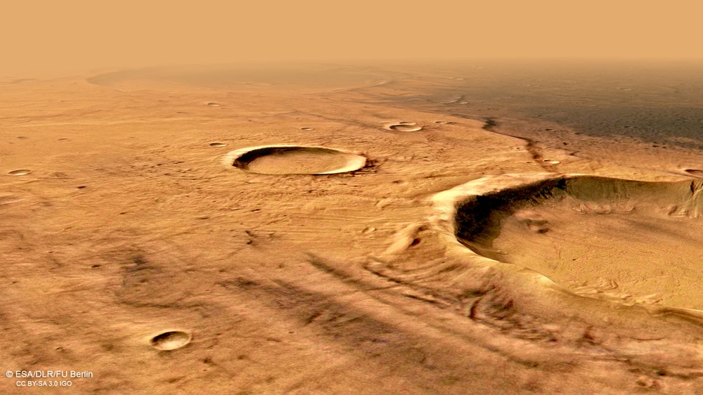
Perspective view of a part of the ancient highland region Terra Cimmeria
Terra Cimmeria is located in the Mars highlands and is one of the oldest landscapes on Mars. The striking shades of light and dark are caused by differences in the mineralogy of the surface material. The HRSC (High Resolution Stereo Camera) images of this region were taken on 11 December 2018 during orbit 18,904. The image resolution is about 13 meters per pixel. This perspective oblique view was generated from the terrain model data as well as the nadir channel and the colour channels of the HRSC.
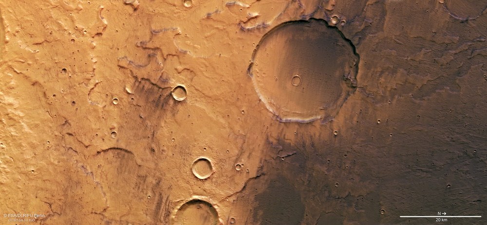
Light and dark coloured crater landscape in Terra Cimmeria
This image, acquired on 11 December 2018 by the HRSC camera experiment developed and operated by the German Aerospace Center (DLR), shows part of the Terra Cimmeria highland region on Mars. The large crater in the centre of the image was probably formed over three billion years ago. This can be seen from the strong weathering of the crater rim and the almost complete filling and levelling of the originally bowl-shaped crater structure by sediments. Bright and very dark areas are clearly visible. The striking light-dark shades are caused by differences in the mineralogy of the surface material. North is to the right of the image.
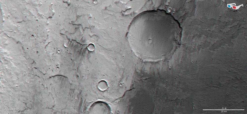
Anaglyph images are produced using the data acquired by the nadir channel of the Mars Express High Resolution Stereo Camera (HRSC), the field of view of which is aligned perpendicular to the surface of Mars, and one of the four obliquely angled stereo channels. When viewed with red-blue or red-green glasses, they provide a realistic, three-dimensional view of the landscape and allow the features of the terrain to be better recognised within this landscape, which is characterised by only slight differences in altitude. North is to the right in the image.
The reason for the striking shades of light and dark, which can also be seen in the pictures of the Terra Cimmeria region, are in fact due to differences in mineralogy.
The dark areas are mainly covered by dark layers of basaltic sand, probably formed from volcanic ash. In the past, five large volcanic provinces and countless small, scattered volcanoes distributed immense amounts of ash across the planet, which was later covered with other rock material.
The HRSC will soon have captured 100 percent of the Martian surface with high-resolution stereo image data, which will be used to generate a global digital terrain model.
Focus: Space, planetary research, Mars
Sand, dust and rocks of different colours cover extensive areas of the Terra Cimmeria highland region, one of the oldest landscapes on Mars. The variations in colour are due to differences in the mineralogy as well as the texture of the surface material and are typical of the ancient Mars highlands. These images were acquired in December 2018 using the High Resolution Stereo Camera (HRSC) developed by the German Aerospace Center (Deutsches Zentrum für Luft- und Raumfahrt; DLR), which has been orbiting the Red Planet on board ESA's Mars Express spacecraft since December 2003.
Originally planned to last only one Mars year (corresponding to two Earth years), the Mars Express mission, entailing seven experiments, has been orbiting Earth's neighbouring planet for almost 16 Earth years now. The HRSC will soon have captured 100 percent of the Martian surface with high-resolution stereo image data, which will be used to generate a global digital terrain model. Approximately two thirds of the planet's nearly 150 million square kilometres (roughly equivalent to the total area of all continents on Earth) have been recorded in resolutions of about 20 metres per pixel and better.
Dark Mars regions once thought to be forests
Bright and dark areas on Mars can even be seen from Earth through a telescope. In the 19th century such observations led to the assumption that Mars had extensive forest areas – that there could at least be vegetation on Mars, if not living creatures. Since the late 1960s, space probes have made it possible to observe Mars at close range. It quickly became clear that although Mars has an atmosphere, it contains almost no water and, above all, is much thinner. As a result, the average temperatures there today are far too low to support life. Even if we cannot rule out the existence of primitive organisms on Mars today or in the past, Mars has certainly never had forests on the scale of Earth's continents.
Different silicate minerals cause the different colourings
The reason for the striking shades of light and dark, which can also be seen in the pictures of the Terra Cimmeria region, are in fact due to differences in mineralogy. Bright areas are covered by dust, which contains a larger proportion of bright silicate minerals in which the eponymous element silicon as well as aluminium, calcium, potassium or sodium form the crystal structure. This is the case, for example, with feldspar minerals, which occur as rock-forming minerals in light volcanic rocks such as rhyolite or the deep rock granite. The silicate content (silicon dioxide, SiO2) of these rocks can be up to 65 percent.
Dark areas, on the other hand, are mainly covered by material consisting of 'mafic' dark minerals such as basalt. Basalt is the most widespread product of magmatic silicate melts on Mars as well as on Earth. They melted in the rock mantle and are lighter than the surrounding rock. As a result, they rise to the surface as thin lava. The main minerals that make up basaltic rock are plagioclase, pyroxene and olivine. Like feldspars, they also belong to the group of silicate minerals, but in contrast, they contain a high proportion of iron, magnesium or titanium. This explains why these minerals are darker than others. The silicate content of basalt is between 35 and 50 percent.
Dark layers of basaltic sand, as in the northern (right) part of the colour image, are probably formed from volcanic ash, which in many places forms impressive dark dune fields on Mars. In the past, five large volcanic provinces and countless small, scattered volcanoes distributed immense amounts of ash across the planet, which was later covered with other rock material. When the dark ash layers formed in this way reappear on slopes, for example in impact craters, the ash is blown away and deposited again over large areas.
Traces of snow, ice and running water
The largest impact crater shown in the images has a diameter of 25 kilometres, but is only about 300 metres deep. Over time, the once bowl-shaped crater was gradually filled with lava, glacier material and river and wind-blown sediments, almost completely levelling out its original shape. In its current appearance it is more reminiscent of a quiche dish than an impact crater. The strongly eroded crater rim and the amount of material deposited within the crater indicate that it is very old, probably over three billion years old.
Mesas and valleys south of the impact crater are the remains of a once extensive river system in Terra Cimmeria. Research suggests that the outflowing water came from melted ice or snow and was probably released during several periods of glaciation.
The top layers that make up the mesas may have come from aeolian deposits. They are comparable to loess deposits (solidified dust sediments), which can be up to several hundred metres thick, as in China, for example. Numerous valley networks cut through these sediments, which are easily eroded by flowing water, as can be seen north of the large impact crater. They most likely flowed into a group of depressions to the north, which probably contained a larger lake called Eridania.
Dust devils reveal dark material
Small, dark dust devil tracks can also be seen in the southern (left) part of the image. These form when atmospheric vortices remove the uppermost, bright layer of dust and expose the darker surface underneath. Starting from the smallest impact craters, (in the bottom left of the picture), so-called south-easterly and erosive wind streaks can also be seen. This type of wind travel occurs when wind speeds increase behind an obstacle (in this case a crater), thereby increasing the erosive force of the wind. As with the dust devils, this removes the uppermost, bright layer of dust, revealing the dark volcanic material underneath. Dust devil tracks and wind streaks are, to some extent, the short-lived witnesses of what is probably the last geological activity on Mars today, primarily the transport of dust and sand by wind.
The name of the region Terra Cimmeria means 'Land of the Cimmerians', the Cimmerians being an equestrian people of antiquity who lived on the northern shore of the Black Sea and in the Caucasus.
The High Resolution Stereo Camera (HRSC) acquired the data from which these images were created on 11 December 2018 during Mars Express Orbit 18,904. The ground resolution is about 13 metres per pixel and the centre of the imaged area is located at approximately 171 degrees east and 40 degrees south. The colour image was created using data from the nadir channel, the field of view of which is aligned perpendicular to the surface of Mars, and the colour channels of the HRSC. The colour-coded topographic view is based on a Digital Terrain Model (DTM) of the region, from which the topography of the landscape can be derived. The reference body for the HRSC-DTM is a Mars equipotential surface (Areoid). The oblique perspective view was generated from the DTM and data from the nadir and colour channels of HRSC. The anaglyph, which provides a three-dimensional view of the landscape when viewed using red-green or red-blue glasses, was derived from data acquired by the nadir channel and the stereo channels.
The HRSC experiment on Mars Express
The High Resolution Stereo Camera was developed by the German Aerospace Center (Deutsches Zentrum für Luft- und Raumfahrt; DLR) and built in collaboration with partners in industry (EADS Astrium, Lewicki Microelectronic GmbH and Jena-Optronik GmbH). The science team, which is headed by Principal Investigator (PI) Ralf Jaumann, consists of 52 co-investigators from 34 institutions in 11 countries. The camera is operated by the DLR Institute of Planetary Research in Berlin-Adlershof.