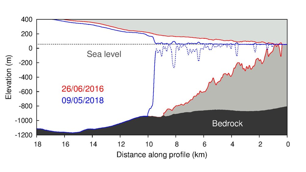
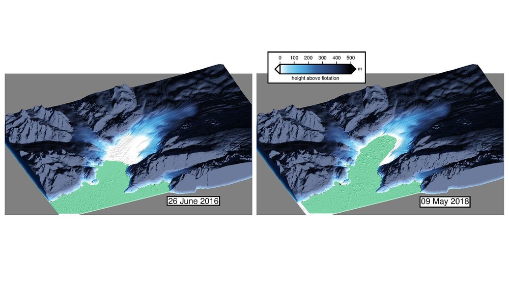
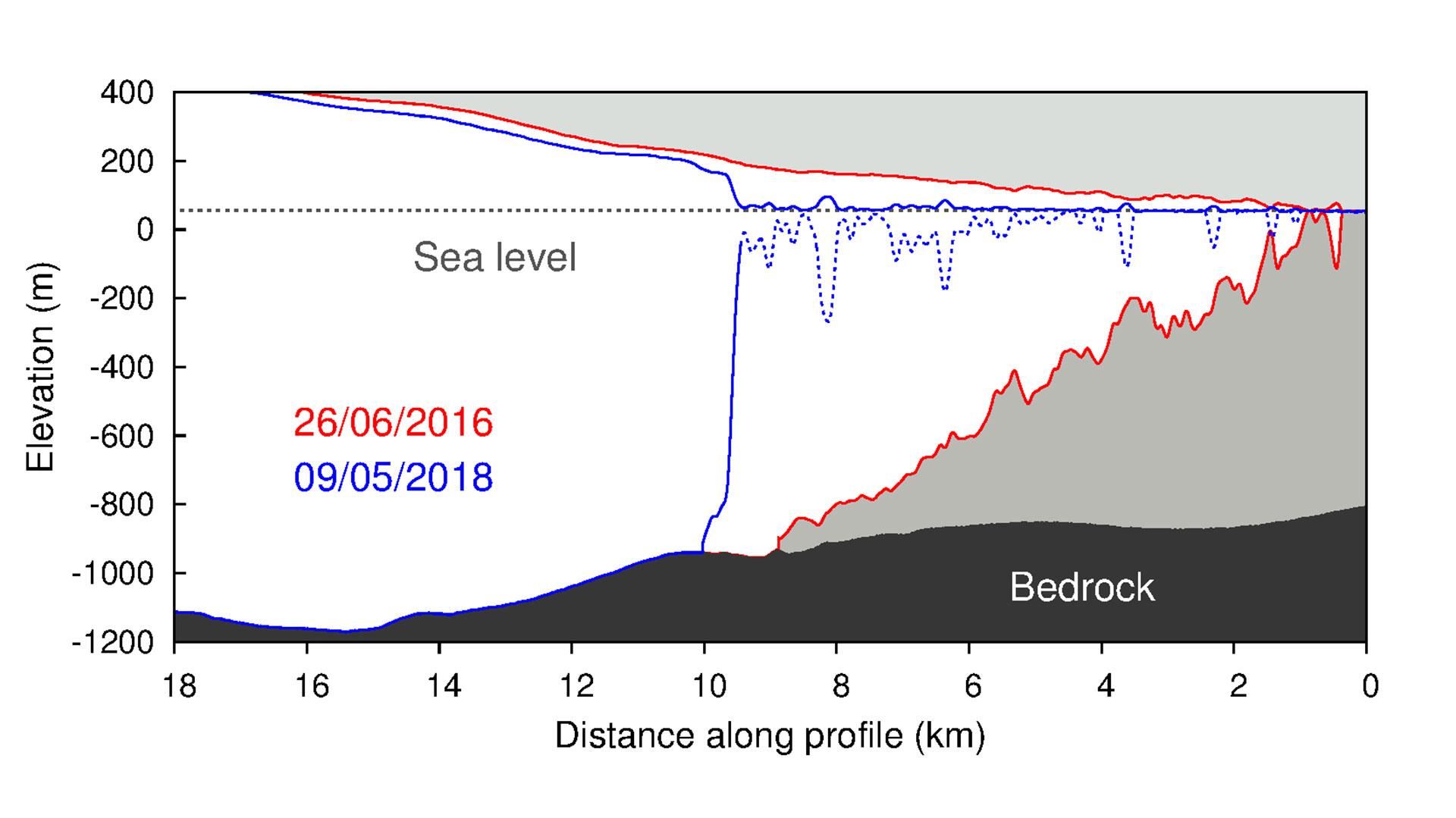
Wherever the glacier surface is above the flotation height, the glacier is resting on the ground. By 9 May 2018, after two years of retreat, the glacier had lost its five-kilometre-long floating tongue. (Topography of the rock under the ice from IceBridge BedMachine Greenland, Version 3.)
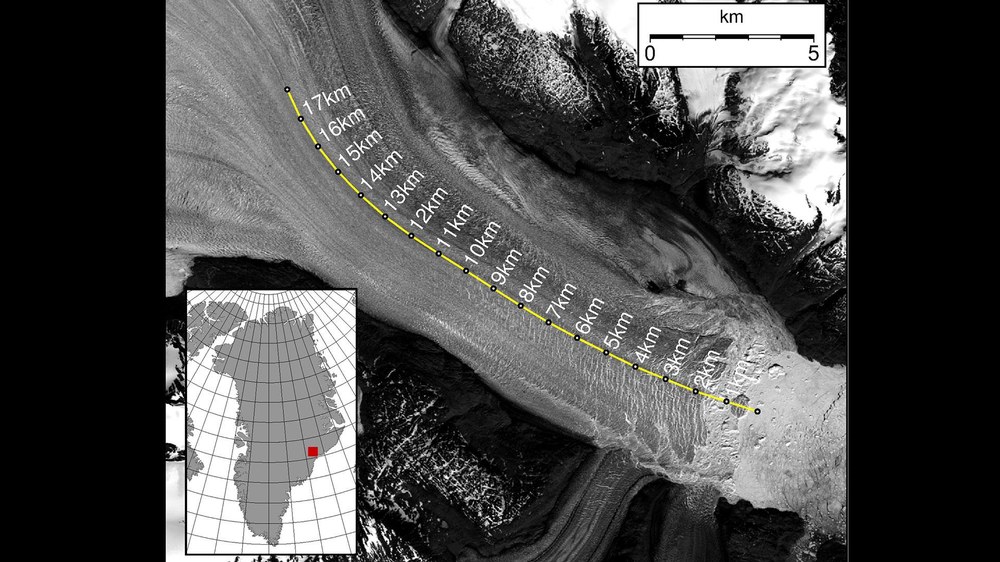
The Kangerlussuaq Glacier is the largest glacier on the southeast coast of Greenland and flows into the fjord of the same name. The glacier front, which in the past was protected by an ice mélange – a mixture of sea ice and calved icebergs – is retreating at an increasing rate. The glacier calves approximately 24 cubic kilometres of ice into the ocean every year. This corresponds to about five percent of the amount of ice lost annually by the entire Greenland ice sheet. Using a time series of 150 TanDEM-X elevation models of the Kangerlugssuaq Glacier, scientists from Swansea University in the United Kingdom have measured the decrease in the glacier’s surface height.
Glacier physics in the Arctic Ocean
Glaciers are very sensitive to temperature changes because they are in direct contact with the sea and the atmosphere. Normally, in winter, an ice melange forms a natural protective shield that restricts or even completely prevents the calving of ice masses. During the summer months, the protective shield is not present, and the calving rate of the glacier increases.
In 2017 and 2018 the ice mélange was weakened. This was probably due to a combination of atmospheric and oceanic warming, so the glacier lost large ice masses even during the winter months. By late summer 2018 – after two years of calving all year round – the Kangerlussuaq Glacier retreated further inland than it has ever done in 80 years of observations. The analysis is based on high-resolution radar data from the TanDEM-X satellites acquired during 2017 and 2018. Supplied with the satellite data by the German Aerospace Center (Deutsches Zentrum für Luft- und Raumfahrt; DLR), the team in Wales used to create digital elevation models using Gamma Remote Sensing software.
Glaciers lose thickness faster when they retreat horizontally. Glaciologist Suzanne Bevan and her colleagues mapped the depth of the glacier bed and fjord floor – and thus determined exactly where the glacier is floating in the water and where it is resting on the land. A comparison of the maps over the two years shows a seasonal advance as well as a clear retreat of the glacier ice front – in addition to the usual slight thickness fluctuations over the seasonal cycle. This has resulted in an elongation, referred to as dynamic thinning and has led to a lowering of the glacier surface. The maps show that between 2016 and 2018 the glacier lost most of its five-kilometre-long floating tongue. In the same period, its thickness decreased by a total of 35 metres.
The TanDEM-X radar satellite mission
TanDEM-X was initiated on behalf of DLR with funding from the German Federal Ministry for Economic Affairs and Energy (BMWi) in public-private partnership with Airbus Defence and Space. DLR is responsible for the scientific use of the TanDEM-X data, the planning and execution of the mission, the control of the two satellites and the generation of the digital elevation models.
The DLR Microwaves and Radar Institute, and the German Remote Sensing Data Centre (DFD) are all involved in the TanDEM-X mission. Together, these institutes address all relevant areas of work, from sensor technologies and mission design to high-precision operational processing and refined user products. Together with the DLR German Space Operations Center, they are also responsible for the ground segment – the infrastructure for operating the satellites and processing the data. The scientific management falls under the remit of the DLR Microwaves and Radar Institute at the DLR site in Oberpfaffenhofen.
Prospects for Tandem-L
DLR has also already designed a possible follow-up mission to TanDEM-X. The Tandem-L mission concept envisages two radar satellites operating in the L-band (23.6-centimetre wavelength) and designed to record dynamic processes on Earth’s surface globally and systematically. The target of Tandem-L is to map Earth's entire landmass on a weekly basis. The mission will set new standards in Earth observation, observe global change at a new level of quality and enable important recommendations for action. The new technology could be used to record the three-dimensional structure of vegetation and ice-covered areas or to measure deformations over large areas with millimetre accuracy.
Contact
Philipp Burtscheidt
Senior editor DLR media relations
German Aerospace Center (DLR)
Corporate Communications
Linder Höhe, 51147 Cologne
Tel: +49 2203 601-2323
Suzanne Bevan
Geography Dept, College of Science, Swansea University
