Technologies for crisis management in the event of a disaster


- DLR provides crisis management solutions and vital aerial image data for trials in Austria
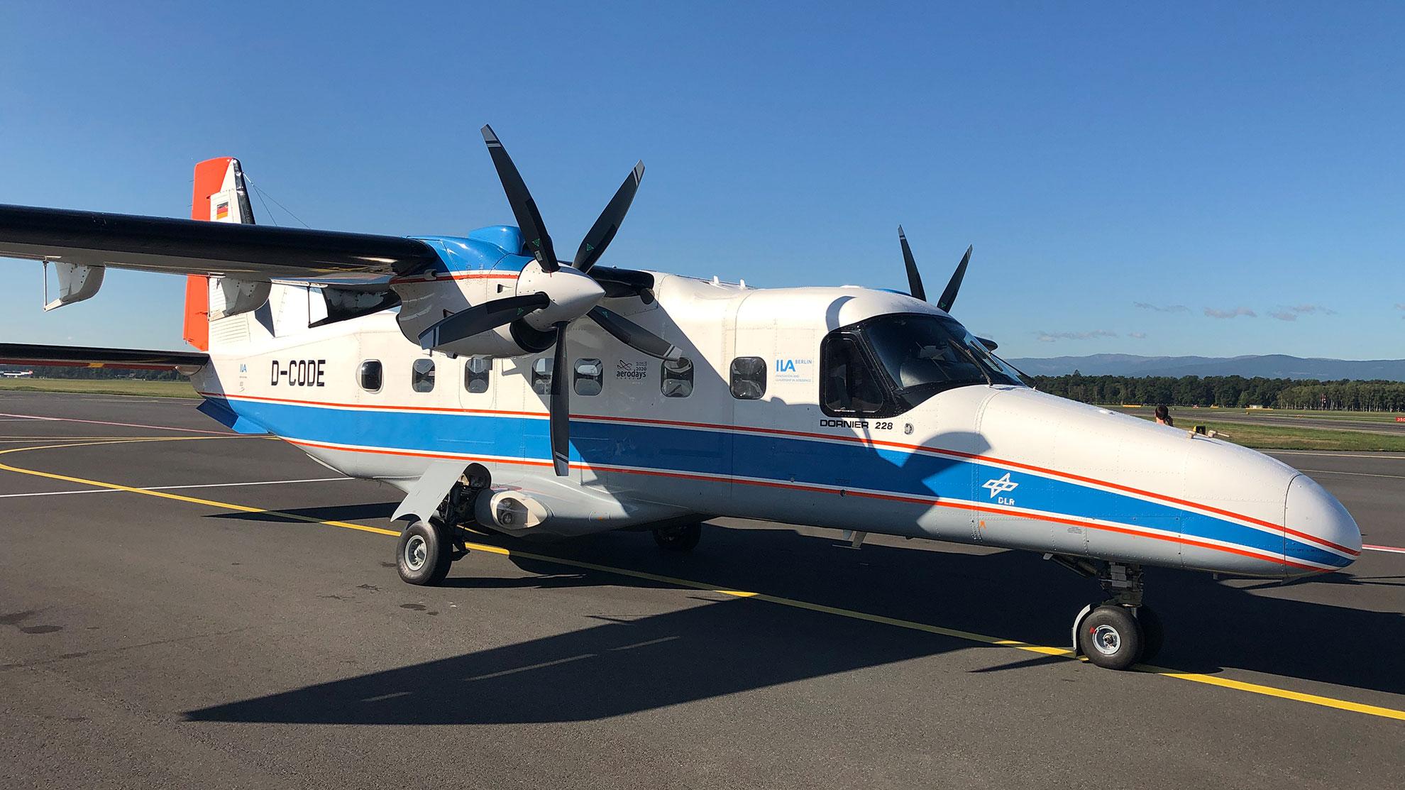
- The DO 228 D-CODE research aircraft in action
- Focus: Security, aeronautics, digitalisation
Earthquakes occur every day in Europe. In July 2019, no fewer than 27 earthquakes with a magnitude of between four and five on the Richter scale were detected, most of them in south-eastern Europe. The EU's DRIVER+ project (Driving Innovation in Crisis Management for European Resilience) conducted a comprehensive disaster management exercise to address this. It was held from 12 to 14 September 2019 in the Eisenerz region of Austria, with a view to strengthening crisis management capabilities. The deployment of innovative developments and technologies was tested within the context of an earthquake scenario and evaluated by experts. The German Aerospace Center (Deutsches Zentrum für Luft- und Raumfahrt; DLR) generated real-time aerial images to provide essential support for position detection and rescue logistics.
Unmanned aerial reconnaissance
Real-time aerial images can make a significant contribution towards quickly and accurately assessing the situation on the ground after a disaster, and thus assist with planning relief operations in a targeted manner. The use of Unmanned Aerial Systems (UAS) has proven particularly effective for this purpose, as they can fly over regions that are difficult to access without endangering emergency or rescue teams.
This is where DLR's work is relevant. Their DO 228 D-CODE research aircraft was used as a demonstrator to show how a UAS could be used for disaster response within controlled airspace. This modified aircraft was controlled remotely using a new digital autopilot via a datalink, like an unmanned aircraft. Two test pilots and a flight test engineer from DLR Flight Experiments were on board for monitoring purposes and to ensure flight safety at all times.
From the map to the air
Operations managers on the ground are able to identify and mark out areas of interest on a map and transmit them to the unmanned aircraft as a request. This request is then translated into a flightpath in real time, taking account of the current conditions (for example, nearby air traffic, weather, visibility, mission objectives) and automatically flown by the UAS. "This marks an important contribution to aeronautics research not just in terms of demonstrating the capabilities of a UAS, but also as a further step towards the safe and efficient integration of UAS traffic into general airspace," says Christian Niermann, the project leader coordinating DLR’s involvement in DRIVER+.
80 square kilometres in 10 minutes
The flight and mission planning for the aircraft was carried out using the UFly ground control station for unmanned aircraft, which was set up by the DLR Institute of Flight Guidance. For DRIVER+, DLR’s D-CODE research aircraft was equipped with a 3K camera system specially designed by the DLR Remote Sensing Technology Institute for use during disaster response missions. Using this camera system, the research aircraft can capture an area of 80 square kilometres in approximately 10 minutes, create geo-referenced aerial images and transmit the results to the ground control station via a datalink. Such aerial images were acquired on several flights during the exercise. Within a few minutes, these were made available to the emergency crews on the ground, who were able to use them to gauge the extent of the damage, coordinate rescue teams and search for injured or missing persons.
The collected data were also forwarded to the Center for Satellite Based Crisis Information (ZKI) at the German Remote Sensing Data Center (DFD). The ZKI created maps interpreting the data to facilitate the straightforward exchange of information. Aerial image data were processed and combined with other geodata for this process in order to provide comprehensive support to both the task forces on the ground and to their control centres. Detailed high-resolution maps and interactive 3D representations were also created during the disaster response exercise. These kinds of 3D views are particularly important in topographically demanding areas like the Eisenerz region, as they can identify potentially hazardous areas and detect changes in the terrain.
The DRIVER+ project
DRIVER+ is an EU-funded project that assists those involved in crisis management to find the best ways of coping with disasters. A total of four trials and a final demonstration will take place over the course of the project. A number of disaster management stakeholders are identifying, testing and evaluating various innovative solutions. Previously identified requirements that have to be resolved or fulfilled have been defined for that purpose. Following three major trials – in Poland, France and the Netherlands – this trial in Austria was the fourth and last in the project, prior to the final demonstration. The DRIVER+ project has received funding from the European Union’s Seventh Framework Programme with the reference number 607798.
The pilot test
The large-scale test in Austria focused primarily on the identification and testing of solutions for overcoming possible shortcomings in the management and support of volunteers. The latter were studied more closely in terms of their current location, tasks, capabilities and the duration of their assignments. In addition, the possibility of merging data from different sources in real time (for example, visualisation of resources, tactical situation, critical asset maps, damaged objects/infrastructure, etc.) was also explored in order to support decision making by the operations managers and to simplify the exchange of crisis-related information.
The simulated scenario
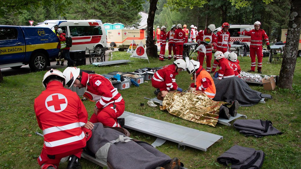
In the scenario, the central region of Austria was hit by a severe earthquake and subsequent heavy rainfall. The Eisenerz area in Styria was particularly badly affected, with large numbers of missing and injured people, collapsed buildings, blocked roads and endangered industrial plants. Residents left their homes and had to spend days outdoors due to fear of aftershocks, a lack of temporary accommodation and the blocked roads. The supply of water, food, shelter, transport and medical care was interrupted. Electricity and mobile communications networks were also severely disrupted.
All local and national agencies (Red Cross, fire brigade, police and armed forces) were deployed. The European Union’s disaster management procedure was activated due to the rapid expansion of the affected area and the fact that national response teams were already working at full capacity. International assistance was requested in order to provide medical care and water treatment facilities, and also to help with search and rescue operations. The difficulty in accessing the affected area and the various impacts of the disaster made it necessary for humanitarian aid and for remote sensing to determine the situation. Many volunteers and a substantial amount of rescue equipment were required to cope with the increasing numbers of people affected.
More information is available on the project website: https://www.driver-project.eu/.