Impressive cloud formations over Mars' northern polar ice cap
January 13, 2020 | Mars Express mission
Impressive cloud formations over Mars' northern polar ice cap
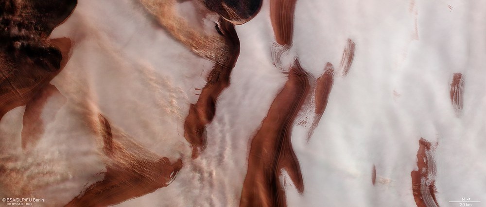
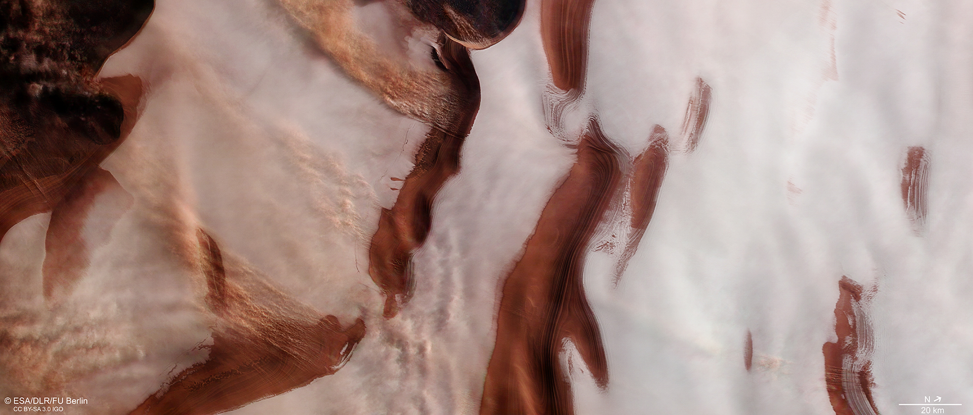
View of part of the northern polar ice cap
Characteristic features of the north polar cap include dark fissures and valleys that spiral outward from the centre of the polar region in a counterclockwise direction. Stratification is visible on the steep slopes, reminiscent of tree rings. This attests to seasonal changes in ice deposits and dust cover due to Martian storms. By examining these layer profiles, scientists hope to gain insights into the development of the Martian climate. The permanent water ice cover at the north pole is over two kilometres thick in places, while the seasonal carbon dioxide ice layers are only a few metres thick. Cloud formations can be seen on the up to two-kilometre-high slopes of some of the valleys; these are local dust storms that are similar to fall winds.
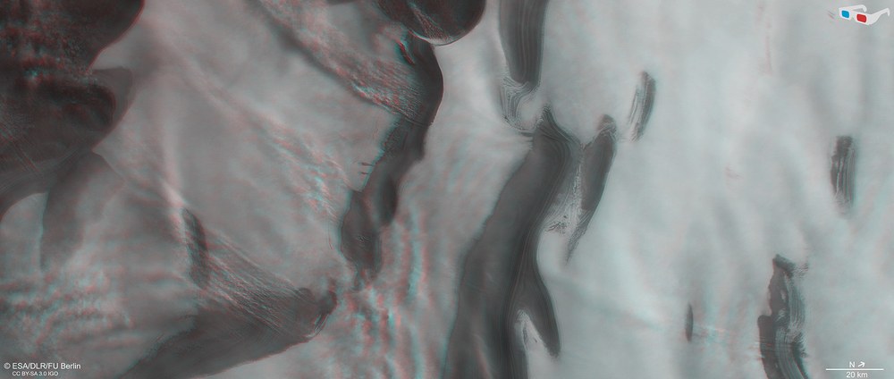
Anaglyph images can be produced from data acquired by the nadir channel (oriented vertically onto the surface of Mars) of the HRSC instrument on board the ESA Mars Express spacecraft and one of the four oblique-view stereo channels. When viewed with red-blue or red-green glasses, these images give a three-dimensional view of the landscape. North is at the top right of the image. This view clearly shows the height difference of up to 2000 metres between the dark clefts in the polar cap, which are several hundred metres deep, and ice-covered hills.
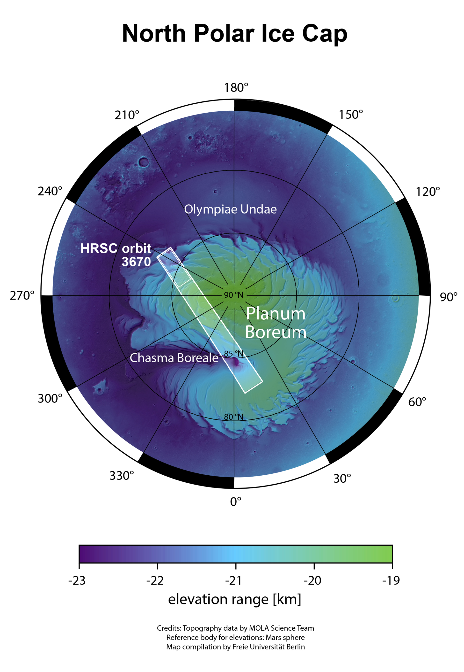
The HRSC camera system operated by DLR on board the ESA Mars Express spacecraft recorded the marked strip during orbit 3670. The landscapes shown here are located in the smaller rectangle. Mars’ northern polar plain, also known as the Planum Boreale, spirals around the Red Planet's north pole.
Images acquired by HRSC show plumes of dust clouds over the ice cap at the Red Planet's north pole. Such observations of active atmospheric processes at the poles are rarely possible, and thus of great interest to scientists.
The characteristic features of the north polar cap include dark fissures and valleys that spiral outwards from the pole centre in a counterclockwise direction like a pinwheel.
On the steep slopes, stratification can be seen which, similarly to tree rings, reflects the seasonal change of ice deposition and dust cover caused by Martian storms.
These images show clouds of dust over our planetary neighbour's northern polar ice cap. They were acquired by the High Resolution Stereo Camera (HRSC), which is operated by the German Aerospace Center (Deutsches Zentrum für Luft- und Raumfahrt; DLR) and has been orbiting Mars on board the European Space Agency (ESA) Mars Express spacecraft since 2004. Such observations of active atmospheric processes at the Martian poles are rarely possible, and thus of great interest to scientists.
Like Earth, Mars has seasons. The Red Planet's polar axis is inclined at around 25 degrees, roughly the same as Earth's tilt. As such, Mars has the equivalent of our polar nights, without any sunlight in winter, and an Arctic or Antarctic summer, when the Sun does not set for months. Temperatures during the night and day vary just as dramatically on Mars, which affects the ice cover.
The appearance of Mars' north polar ice cap changes constantly over the course of a year. During the summer half, we see a permanent ice cap, part of which can be seen in this image. It essentially consists of water ice and has a diameter of approximately 1100 kilometres. It is estimated to have a volume of 1.6 million cubic kilometres, which equates to slightly over half the Greenland ice sheet, and is over two kilometres thick in places. Almost no impact craters can be seen on the ice, which indicates that the polar cap in its current form is not particularly old.
Dry ice allows the north polar cap to grow strongly over winter
During the winter half of the year, temperatures at the Martian north pole fall to below minus 125 degrees Celsius, and even in the temperate latitudes of the hemisphere in which it is winter, temperatures can drop to minus 40 degree Celsius or even lower during the day. At these low temperatures, a considerable proportion of the carbon dioxide from the thin Martian atmosphere condenses into ice ('dry ice') close to the poles and precipitates onto the surface. This enlarges the ice cap, forming what is known as the seasonal ice cap, consisting of a one- to two-metre-thick layer of carbon dioxide ice. This extends to 70 degrees north latitude. As a result, at this time of year the polar cap is often enshrouded in thick carbon dioxide clouds, making it difficult to observe from orbit. When spring sets in, the season layer of carbon dioxide ice quickly sublimates once again, turning directly into gas
The dark fissures between the gleaming white deposits of water ice are part of an impressive system of valleys that spiral outwards from the centre of the polar region in a counterclockwise direction. In places, these are up to two kilometres deep, making them similar in scale to the Grand Canyon, and cut through the layered deposits of the polar cap, which consists of a mixture of ice and dust. The transition between layers of ice and dust documents the development of the Martian climate over the last few millions of years, similarly to the annual rings of a tree.
Wind and dust storms carve deep valleys in the polar cap
The evaluation of radar data suggests that wind erosion is the driving force in the formation of spiral-shaped grooves. According to one theory, the valleys, with their cyclically formed steps, have been made by the impact of katabatic winds on the ice. Katabatic winds (from the Greek word katabasis, meaning descending) are downslope currents of cold, dense masses of air. They are caused by differences in density and form when, for example, cold, dry air flows from higher-lying surfaces of ice or snow into lower-lying areas with warmer, less dense air. These are commonly referred to as fall winds, as on Earth they often occur in the afternoon when the temperature differences are at their greatest, below glacier tongues.
In the case of Mars' polar cap, the air movement is directed radially outwards from the centre of the polar region and is also affected by the same Coriolis effect that exists on Earth. The Coriolis force, which acts upon gas masses in the atmosphere, is named after the French mathematician and engineer Gaspar de Coriolis (1792–1843) and is caused by the rotation of the planet, whereby the rotational velocity of a point on the surface decreases continuously from the equator (maximum) to the pole (zero). If air masses flow from temperate latitudes to the poles, they take the momentum of the planetary rotation with them and are deflected to the east. Even if 'slower' masses of air flow from the pole, they are 'overtaken' by the faster surface of the Earth and likewise deflected. This created spiral patters in atmospheric currents. The winds interact with the surface of Mars, creating the striking topographical spiral pattern of valleys and ridges.
The spectacular cloud formations in this HRSC image are small, local dust storms that are oriented perpendicular to the troughs and are particularly prevalent on the slopes of fissures that run towards the equator. This type of dust movement increases erosion and the regression of the steep slopes. Both sublimation and erosion due to the katabatic winds appear to be active aeolian processes that play a major role in the long-term alteration of valleys.
Systematic processing of the data acquired by HRSC took place at the DLR Institute of Planetary Research. From these data, staff in the Department of Planetary Sciences and Remote Sensing at the Freie Universität Berlin created the image products shown here. The image data were acquired by HRSC on 16 November 2016 during Mars Express orbit 3670. The image resolution is approximately 15 metres per pixel. The centre of the images is located at approximately 244 degrees east and 85 degrees north. The colour image was created using data from the nadir channel, the field of view of which is aligned perpendicular to the surface of Mars, and the colour channels of HRSC. The anaglyph, which provides a three-dimensional view of the landscape when viewed using red-green or red-blue glasses, was derived from data acquired by the nadir channel and the stereo channels.
The HRSC experiment on Mars Express
The High Resolution Stereo Camera was developed by the German Aerospace Center (Deutsches Zentrum für Luft- und Raumfahrt; DLR) and built in collaboration with partners in industry (EADS Astrium, Lewicki Microelectronic GmbH and Jena-Optronik GmbH). The science team, which is headed by Principal Investigator (PI) Ralf Jaumann, consists of 50 co-investigators from 35 institutions in 11 countries. The camera is operated by the DLR Institute of Planetary Research in Berlin-Adlershof; it has been delivering high-resolution images of the Red Planet since 2004.

