An in-depth look at the geological context of the Mars 2020 landing site through the eyes of DLR's HRSC instrument
February 16, 2021
An in-depth look at the geological context of the Mars 2020 landing site through the eyes of DLR's HRSC instrument
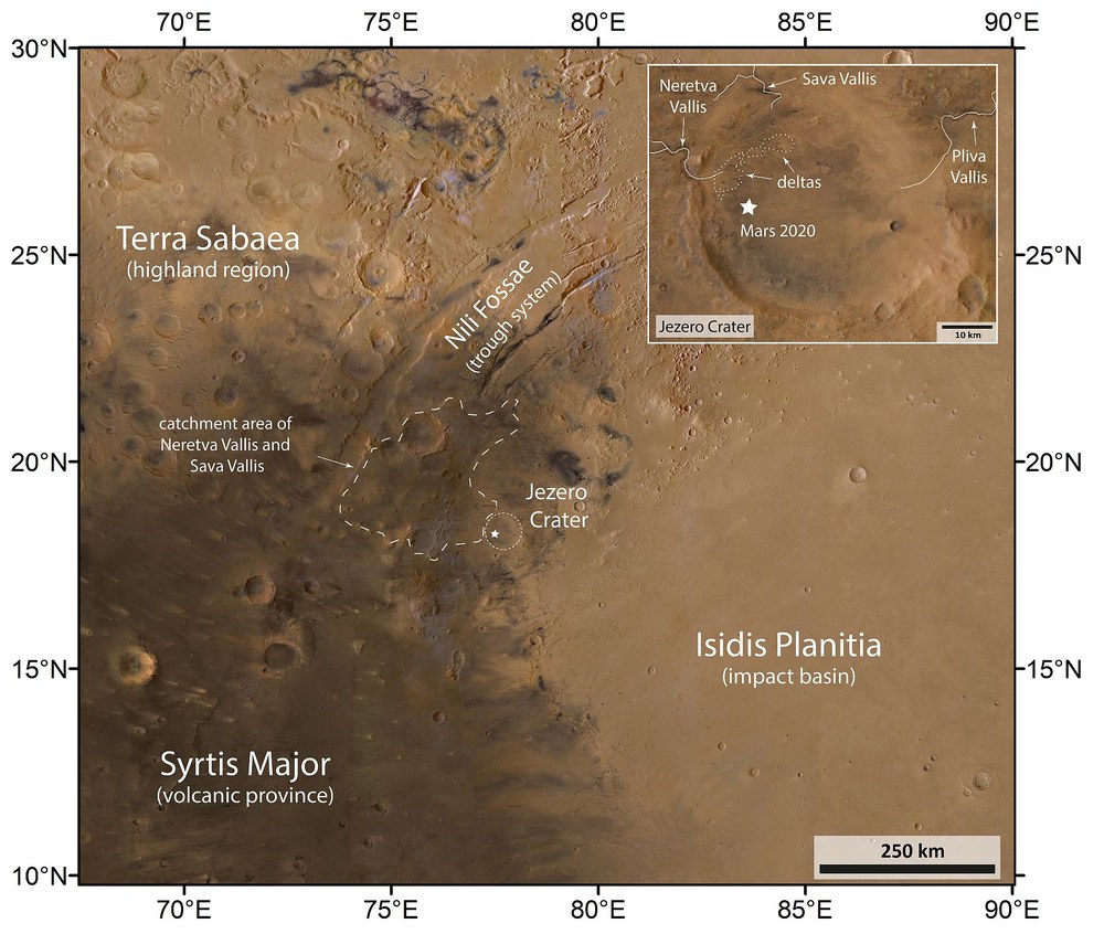
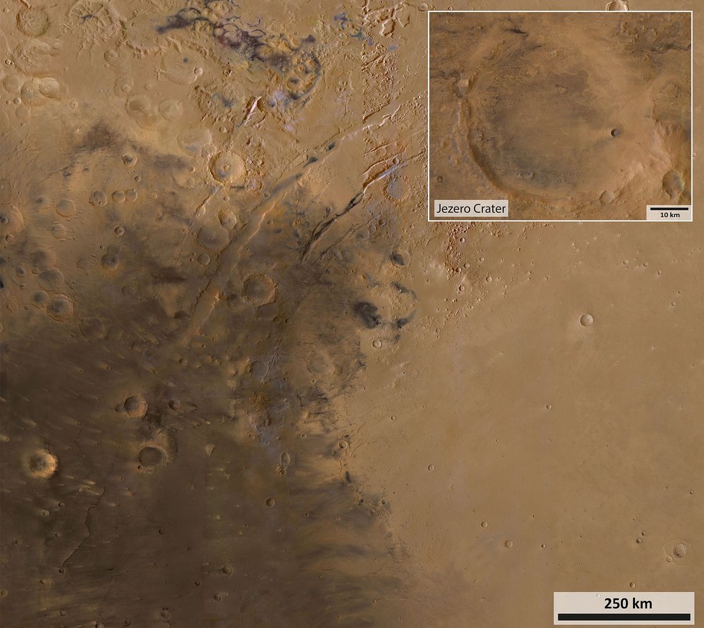
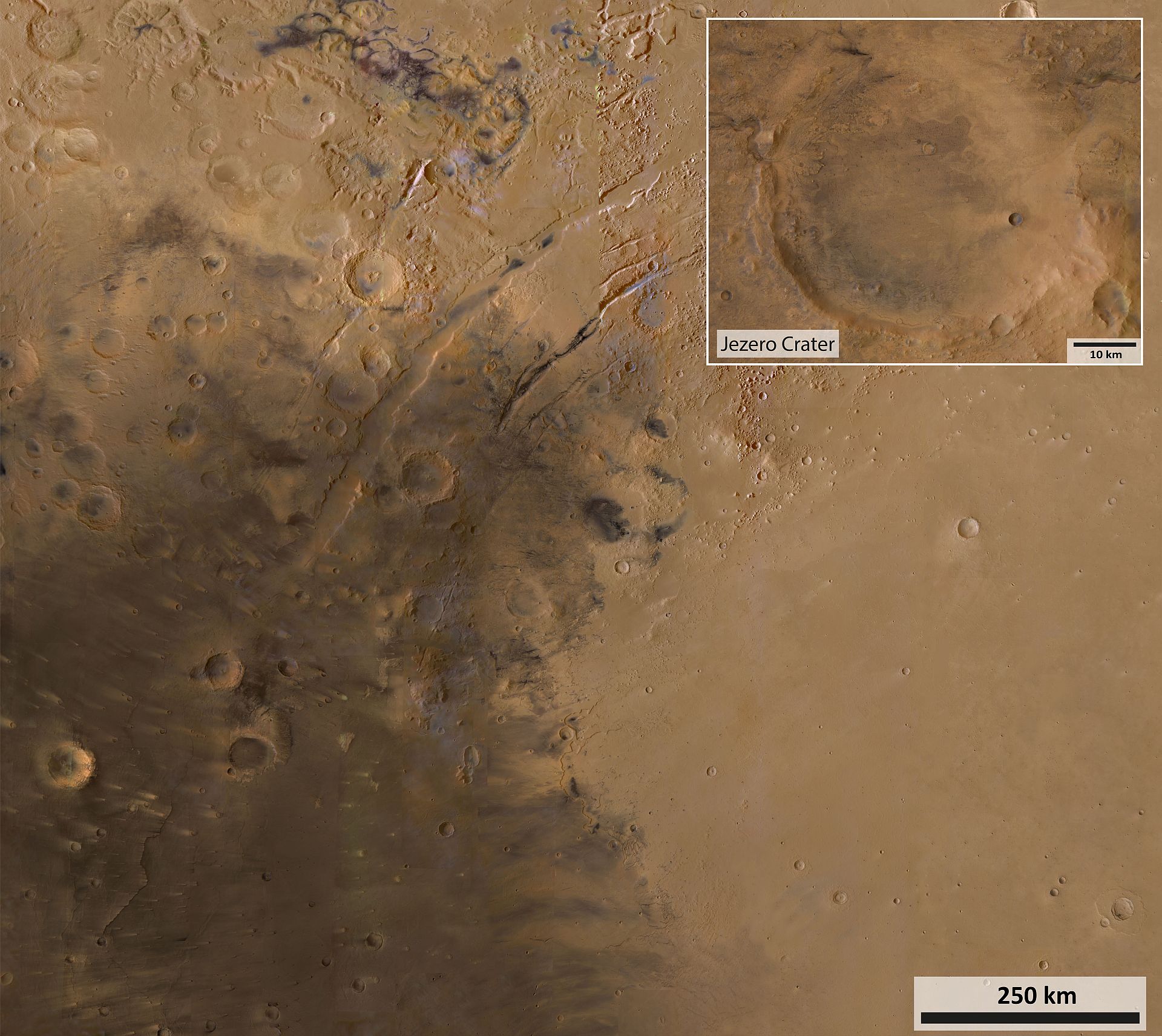
Image of the region around Jezero Crater
Jezero Crater lies exactly on the boundary between the ancient highland region of Terra Sabaea and the similarly aged Isidis impact basin, whose present-day Isidis Planitia plain was formed primarily by significantly younger deposits. The nearby Nili Fossae graben system, which roughly traces the shape of the Isidis basin rim through its curvature, was formed precisely by this impact as a result of tectonic fractures. Adjoining Jezero Crater to the southwest is the volcanic region of Syrtis Major. This image was created from the red, green and blue channels of HRSC and combined with high-resolution data from its nadir channel, which is directed perpendicular to the surface of Mars. The dark, bluish-black areas are covered by a layer of ancient volcanic ash that is widely dispersed by the wind and often piles up into impressive dune fields. The high resolution of the data processed for this image allows for greater enlargement, enabling a closer look at individual details of the landscape. For this image, small gaps in the image mosaic were interpolated.
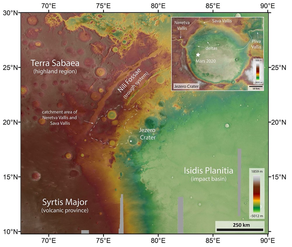
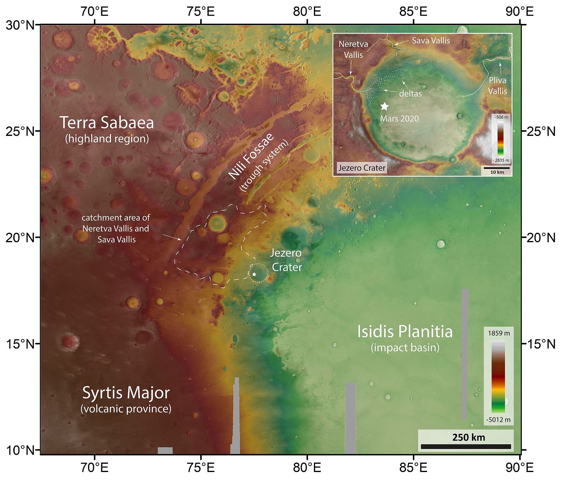
Topographic map of the surroundings of Jezero Crater
DLR's High Resolution Stereo Camera (HRSC) orbits Mars on board ESA's Mars Express spacecraft. Its nine sensors, arranged at right angles to the north-south flight direction, record the surface of Mars from different angles and in four colour channels. From the four inclined stereo channels and the nadir channel, which is directed perpendicular to the surface of Mars, scientists at the DLR Institute of Planetary Research and the Freie Universität Berlin compute digital terrain models, which assign elevation information to each pixel. The height difference in this area of 1.5 million square kilometres (see key at bottom right), from the lowest point in Isidis Planitia to the highest crater rim in Terra Sabaea, is over 6800 metres – the floor of Jezero Crater lies at an elevation of approximately minus 2600 metres. The elevation data in this image is referenced to the Mars Areoid, a notional line of equal gravitational attraction, analogous to sea level on Earth. The high resolution of the data processed for this image allows for greater enlargement of the images for a closer look at individual details of the landscape.
These images show the topography of the Jezero Crater and its surroundings. They were created using data from the High Resolution Stereo Camera (HRSC) operated by DLR; these data make it possible to create views of large areas of the Martian surface as digital terrain models.
HRSC's high-resolution digital terrain models have made important contributions to the selection of numerous landing sites on Mars – including for NASA's Mars 2020 mission.
The HRSC stereo camera has been mapping the Red Planet in unprecedented resolution, in three dimensions and in colour since 2004 as part of ESA's Mars Express mission.
Focus: Space, planetary research
On Thursday, 18 February 2021, at approximately 21:55 CET, NASA's control centre in Pasadena should receive the radio signal indicating that the Perseverance rover has been gently lowered onto the surface of Mars by a 'sky crane' as part of NASA's Mars 2020 mission. Perseverance's new home will be the floor of a former lake in the Jezero impact crater. There, the mobile laboratory, which is the size of a small car, will begin its search for traces of past life and collect samples for later return to Earth.
The High Resolution Stereo Camera (HRSC) operated by the German Aerospace Center (Deutsches Zentrum für Luft-und Raumfahrt; DLR) has been imaging the Red Planet, in three dimensions and in colour, since 2004 as part of ESA's Mars Express mission. The data it collects make it possible to create images of large areas of the Martian surface – not only as colour mosaic images, but also as digital terrain models. These provide researchers with important information about the terrain and elevation of the land, also known as the topography of the region.
HRSC's high-resolution digital terrain models have made important contributions to the selection of numerous landing sites on Mars, including that of the Mars 2020 mission. Accurate topographical information is critical for ensuring a safe landing.
The latest map sheets, each covering an area of over three million square kilometres, can be downloaded from the website of the HRSC team at DLR and from the map server of the Freie Universität Berlin. One of these map sheets (MC-13 East) was used for the image products shown here. This section depicts the wider geographical context around the landing site, located at approximately 18 degrees north and 77 degrees east. The area shown is more than 1.5 million square kilometres (1330 by 1195 kilometres – over twice the size of the Iberian Peninsula) and gives a good overview of the location of the impact crater and the geological context. However, the maps shown here not only provide a large-scale overview of the geographic location, they also provide an outstanding view of detail that is exceptional for such large-scale images. The high resolution of these image here allows them to be greatly enlarged for a closer look at individual detail of the landscape.
The extraordinary geological diversity of this region helped Jezero Crater finally come out on top after the intensive, meticulous selection of the landing site, which took five years. The crater lies exactly on the border between the ancient highland region of Terra Sabaea, where rocks from the Martian Palaeozoic (the Noachian: 4.1–3.7 billion years ago) can still be found, and the similarly ancient Isidis impact basin, which was formed 3.9 billion years ago. However, its present-day Isidis Planitia plain was formed primarily by much younger deposits formed in the Martian Middle Ages, the Hesperian (3.7–3.0 billion years ago) and the Martian Modern (the Amazonian 3.0 billion years to present day). The nearby Nili Fossae graben system, which roughly traces the shape of the rim of the Isidis basin through its curvature, was formed precisely by this impact as a result of tectonic fractures. To the southwest of Jezero Crater is the volcanic region of Syrtis Major, whose most recent lava flows are also assigned to the Hesperian. Thus, the rocks and deposits in and around the crater originate from all three geological epochs of Mars.
A simulated flight over Jezero Crater on Mars. Home to a standing body of water more than 3.5 billion years ago, this crater is where NASA’s Mars 2020 mission Perseverance rover will land to search for signs of past microbial life. The video is based on data from the High Resolution Stereo Camera (HRSC) on board ESA's Mars Express spacecraft, which has been in orbit around Mars since 2003. HRSC is operated by the German Aerospace Center (DLR).
Flight over Jezero Crater – landing site of the Mars 2020 mission
Your consent to the storage of data ('cookies') is required for the playback of this video on Youtube.com. You can view and change your current data storage settings at any time under privacy.
Flight over Jezero Crater – landing site of the Mars 2020 mission
A simulated flight over Jezero Crater on Mars. Home to a standing body of water more than 3.5 billion years ago, this crater is where NASA’s Mars 2020 mission Perseverance rover will land to search for signs of past microbial life. The video is based on data from the High Resolution Stereo Camera (HRSC) on board ESA's Mars Express spacecraft, which has been in orbit around Mars since 2003. HRSC is operated by the German Aerospace Center (DLR).
Credit:
ESA/DLR/FU Berlin/HRSC Science Team
A crater lake left behind a diverse mineralogy
In addition to the different ages of the rocks in the vicinity of Jezero Crater, their diverse mineralogical composition is particularly interesting, as researchers can use the minerals to infer the environmental conditions at the time of their formation. The Perseverance rover will be able to study them directly in the crater. The detailed map of Jezero Crater (top right) shows that the crater rim is breached by three valleys which were former rivers. Neretva Vallis and Sava Vallis were inflow channels that have created two deltas on the western and northwestern rim of the crater, which are also considered evidence for the existence of a former lake. Perseverance will examine the larger of the two in the west in more detail.
Pliva Vallis in the east of Jezero Crater was an outflow channel through which water was discharged from the crater. This is why this former crater lake is referred to as an 'open basin lake'. These lakes were once numerous on Mars. Compared to closed basins (with inflow but no outflow), they are interesting because they were freshwater lakes with a stable water level. Lakes in closed basins, on the other hand, were subjected to more frequent periods of drying out, which turned them into salt lakes, thus making them less promising in the search for conditions that are conducive to life.
The large map shows the water catchment area of the two inflow channels, from which material from the surrounding area was transported by the rivers into the crater and deposited in the two deltas. Spacecraft orbiting Mars have used spectrometers to detect a variety of minerals in this catchment area. These are mainly silicates from the olivine and pyroxene groups, both mineral classes that originate from magma within the Martian mantle and indicate basaltic volcanic deposits that were not subject to long-term weathering by water. Even more exciting, however, are the carbonates identified on the inner rim of Jezero Crater, which have rarely been found on Mars thus far, and which, together with the clay minerals more frequently found on Mars, testify to the weathering by water of rock with a volcanic source.
Volcanic minerals, carbonates, clay minerals – these three types of deposits have been found both in the delta and elsewhere in the crater. Some carbonates (limestones) are thought to have been formed directly in the lake. Such lake carbonates and especially the clay minerals indicate freshwater conditions that enable life and have the potential to preserve traces of life – biosignatures – particularly well in their interior. However, other types of minerals have also been discovered there, namely those that paint a different picture of the crater lake. These include sulphates that contain iron oxide, amorphous silicon oxides and hydroxides, which tend to form in acidic waters that gradually dried up. These minerals indicate that the environmental conditions in Jezero Crater became drier and less conducive to life at a later stage. However, even among these minerals there are some in which biosignatures can be very well preserved.
In addition, it will be particularly important to study materials of magmatic origin that are also found on the crater floor. If a sample of lava or other volcanic rock, as unaltered as possible, could be examined on site or even brought to Earth, this would provide insights into the inner development of the planet.
Jezero Crater's surroundings are also worth a visit
If everything goes well and the rover is still functioning after the nominal mission duration of one Martian year (two Earth years), it would be possible to start studying the closer surroundings outside the crater. This would allow Perseverance to be used to investigate some of the oldest rocks formed during the Isidis impact – known as megabreccias, these agglomerated debris could provide valuable information about the early history of Mars. To achieve this aim, a route west out of the crater would need to be planned to reach Noachian bedrock, igneous rocks and lava flows from Syrtis Major. This would allow researchers to gain, refine and substantiate comprehensive on-site knowledge of the lithology throughout Martian history. Not to mention that the rover could also collect samples of these rocks for transport back to Earth, which would provide extraordinary scientific added value.
In addition to the search for molecular remains of possible former life forms, the main goal of the Mars 2020 mission is to collect samples for transport to Earth in the early 2030s. The aim is to obtain the most promising and diverse samples possible and deposit them on the surface of Mars for later return. The analysis of samples in laboratories on Earth can provide more accurate results than can be obtained with instruments on Mars rovers. Perseverance can only take samples from a relatively shallow depth of a few centimetres. However, it is thought that traces of former life are most likely to be found at greater depths, where they may have been protected from the degrading effects of UV radiation at the surface and the cosmic radiation that penetrates deeper into the soil. These deeper traces may have remained preserved over Martian history. Finally, it is assumed that the best environmental conditions for the existence of life (habitability) prevailed about 3.7 to 3.4 billion years ago. Incidentally, life on Earth also emerged during this period.
As part of the European Space Agency (ESA) ExoMars 2022 mission, the next Mars rover – Rosalind Franklin – is scheduled to land in Oxia Planum on 10 June 2023. This rover has been designed to reach deeper into the subsurface. It will be able to collect core samples from depths of up to two metres and examine them for biosignatures directly on site using highly specialised instruments inside the rover.

