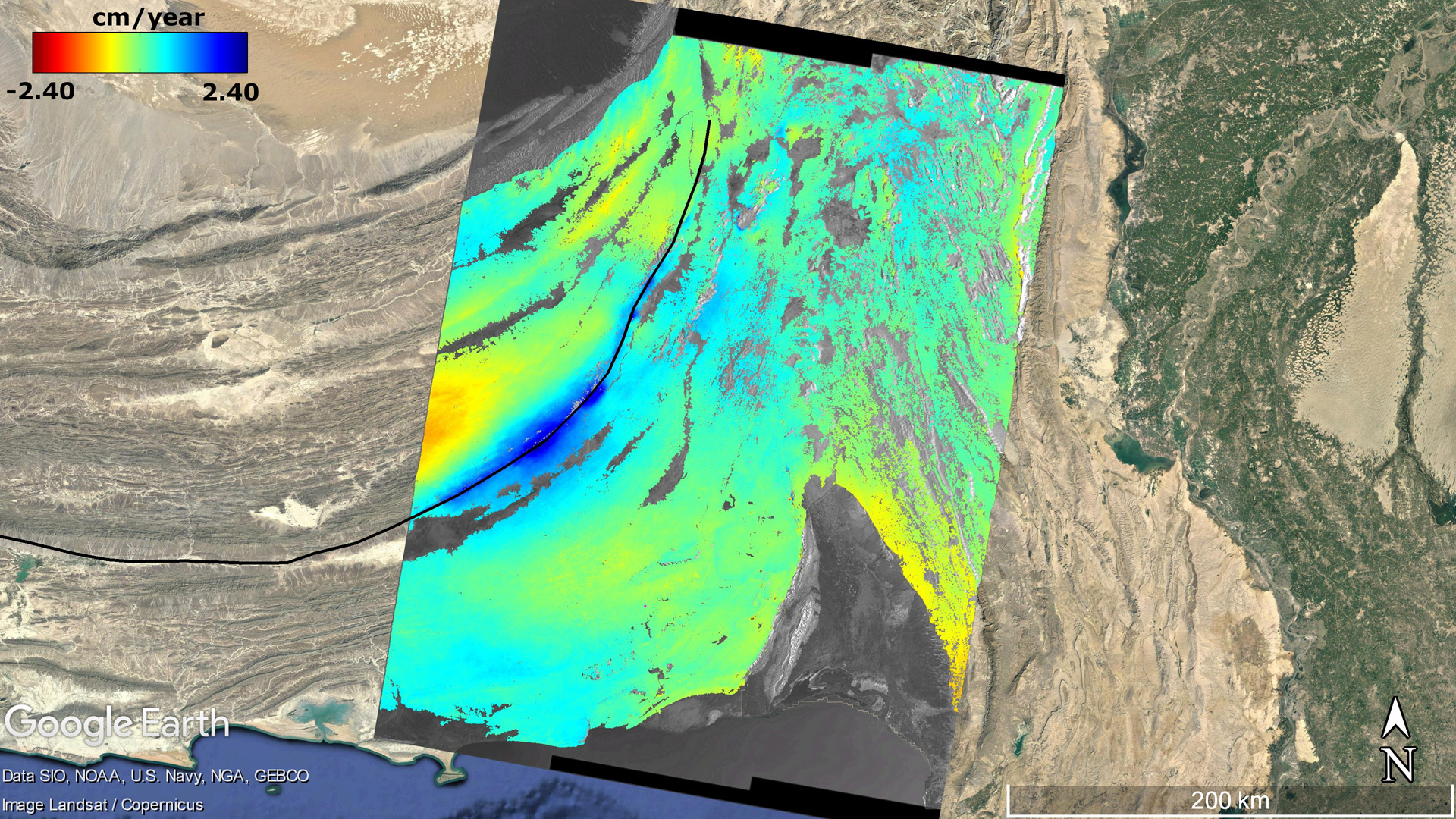
Map of deformation velocity created using 50 Sentinel-1 images acquired over the Hoshab Fault (indicated by the solid black line) in Balochistan, Pakistan. The colours indicate whether the Earth's surface is moving away from the radar (red colour) or towards it (blue colour). The movement is mainly parallel to the fault, which is mostly oriented north-south, on its right side. Since the satellite follows a quasi-polar orbit (mainly north-south oriented) and the radar looks 90 degrees to the right, it cannot detect the movement taking place on this part of the fault. It is only when the fault begins to bend in an east-west direction that the movement is detected, as can be seen from the reddish area to the left of the Sentinel-1 image. The special configuration of the Harmony satellites will enable the accurate measurement of the north-south component of the deformation and thus the observation of three-dimensional deformation phenomena worldwide.
Representation of the stereo (left) and cross-track (right) flight formations for Harmony
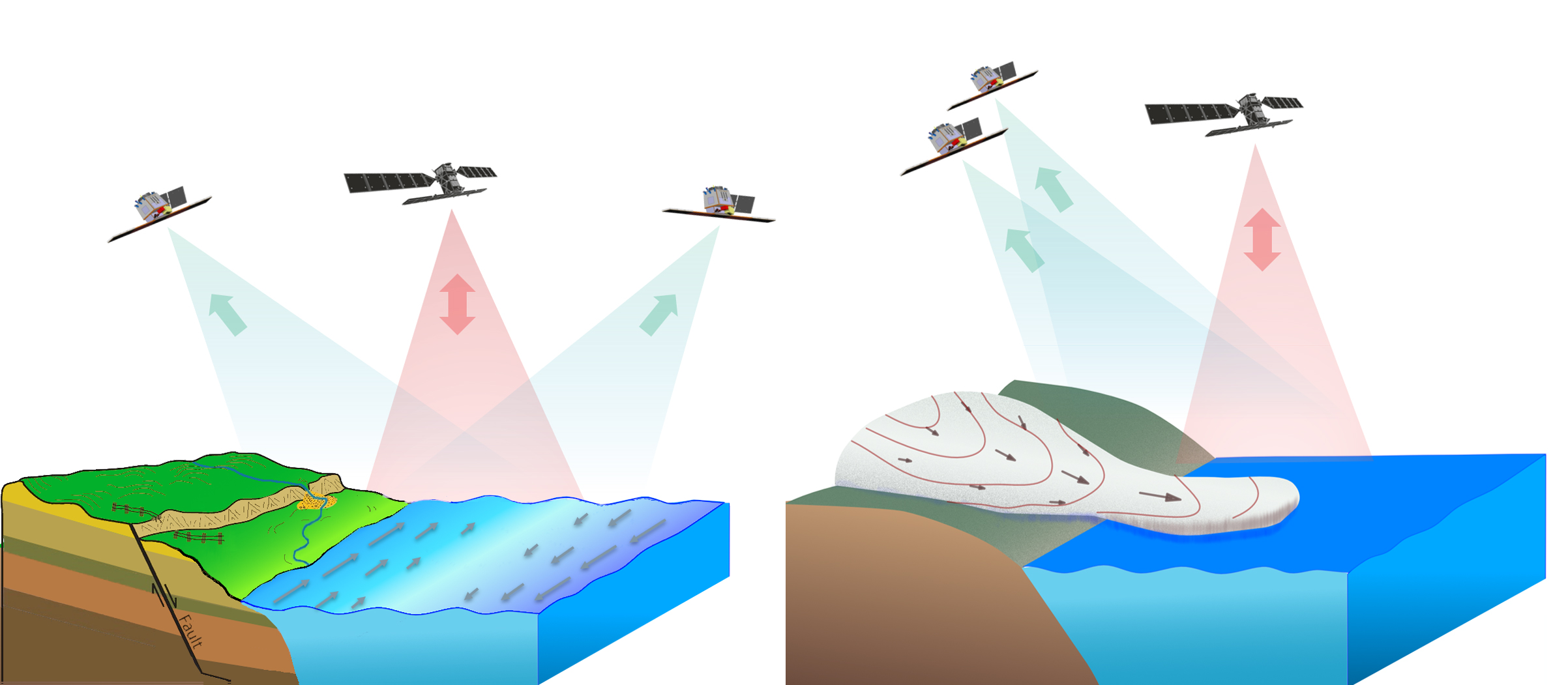
Representation of the stereo (left) and cross-track (right) flight formations for Harmony. The satellite Sentinel-1 is shown in black. Sentinel-1 transmits signals and picks up the backscattered echoes (shown with pink arrows), while the Harmony satellites receive some of the energy that is reflected back to them (shown with the green arrows).
'Harmony' is intended to answer important scientific questions about changes to oceans, ice and land.
ESA has selected 'Harmony' as a future mission in the field of Earth observation.
Focus: Earth observation, space, global change
Understanding the changes happening to Earth and its delicate balance is of ever increasing importance. "With the Harmony mission, we have the opportunity to gain new insights into processes that take place within the Earth system. This represents a considerable scientific and technical challenge," says Alberto Moreira, Director of the German Aerospace Center (Deutsches Zentrum für Luft- und Raumfahrt; DLR) Microwaves and Radar Institute.
Spotlight on oceans, land and ice sheets
The Earth observation mission Harmony will focus on the observation and evaluation of the smallest movements at the air-sea interface, such as those of the wind, waves and surface currents, as well as alterations to solid earth, including tectonic deformations and height changes on volcanoes and in the cryosphere – that is, glacier flows and height changes. The Harmony mission will employ two satellites, which will orbit with one of the Copernicus Sentinel-1 satellites, flying in two different formations. In stereo formation, the Harmony satellites will be positioned at 350 kilometres in front of and behind the Sentinel-1 satellite. In close flight formation, both Harmony satellites will fly relatively close to one another – approximately 200–500 metres apart – and at a distance of 350 kilometres from Sentinel-1. Each Harmony satellite will carry a passive Synthetic Aperture Radar (SAR) as its primary payload. These will capture the reflections of signals sent by Sentinel-1 to Earth. A multibeam thermal infrared camera will also be on board each satellite. These will measure the height and the motion vectors of clouds. "Through the interaction between the three satellites, we will be able enable to measure the deformation of Earth's surface in three dimensions and determine the speed of ocean currents with an unprecedented accuracy of 0.2 metres per second," says Moreira.
Towards an exact picture
Researchers at the DLR Microwaves and Radar Institute are part of the team that submitted the initial proposal for the mission. DLR's contributions focus on the conception of the Harmony mission and the radar system, the consolidation of user and radar system requirements, and assessment of the overall system performance. At the same time, they are endeavouring to devise a new process for synchronisation between the radar systems of the Harmony satellites and Sentinel-1. In addition, the Institute is developing a complex software tool to calculate the performance of the radar systems and create simulated radar images. In a next step, algorithms will be used to generate three-dimensional deformation maps of Earth's surface and calculate topographical changes at volcanoes. This will prove that the user requirements for the accuracy of measurements will be met. Last but not least, the Institute conducted an airborne campaign using the airborne SAR system in northern Canada and recorded further data with the satellites TerraSAR-X and TanDEM-X, surveying the surface of the sea around the Caribbean island of Barbados. The scientists will use these results to prepare data utilisation techniques for the mission.
Venturing further into the future
Over the last two years, three missions – Daedalus, Harmony and Hydroterra – have been assessed for their scientific, technical and financial feasibility as the tenth ESA Earth Explorer mission. In 2018, these were selected from 21 submitted proposals for a feasibility study. "Our next challenge is the successful implementation of Phase A of the Harmony mission. The industrial and scientific teams have another year and a half of hard work ahead of them to show that the mission has reached a sufficient level of technological and scientific maturity to proceed to the implementation phase, which will ultimately lead to the launch of the Harmony satellite by the end of this decade," explains Moreira.
This phase includes a further feasibility assessment, including the design of the satellite platform and its instruments, flight operations planning and additional technological developments.
Pau Prats, a member of the ESA Mission Advisory Group for Harmony and a researcher at the DLR Microwaves and Radar Institute, is convinced of the benefits of this mission: "The unique configuration of the Harmony satellites combined with Sentinel-1 will bring a new dimension to the SAR observations, thus paving the way for completely new applications over the next two decades."


