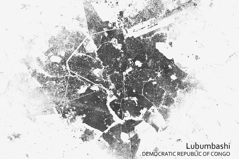
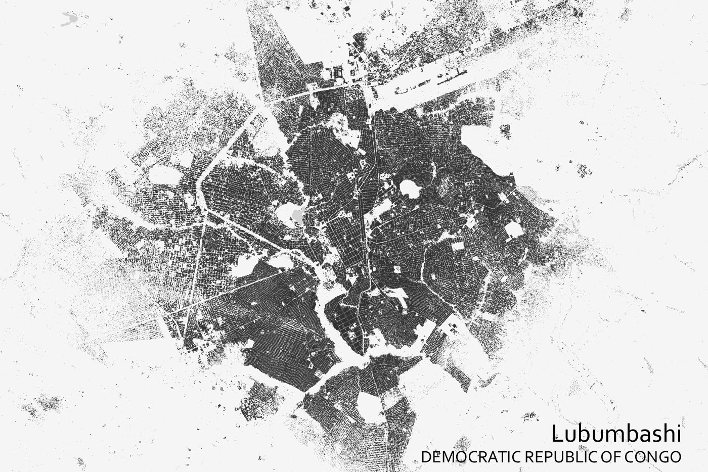
World Settlement Footprint (WSF) 2019 – Lubumbashi
Lubumbashi, Democratic Republic of the Congo. WSF 2019 provides information on settlements with an unprecedented level of accuracy. Data from the Copernicus satellites Sentinel-1 and Sentinel-2 were processed for this purpose.
DLR and ESA have joined forces with Google to create a dataset on settlements that covers the entire world.
These findings will contribute towards a better understanding of urbanisation and support sustainable urban planning.
Various satellites have been mapping Earth's surface at a resolution of just a few metres.
Focus: Space, digitalisation, Earth observation, sustainability, climate change, Big Data
Fifty-five percent of the world's population lives in cities. The UN estimates that this figure could rise to 68 percent by 2050. Cities will continue to grow, sometimes rapidly and without any formal planning. This can make them more vulnerable to disasters or lead to issues with supplying water, raw materials and energy. To achieve a better understanding of how cities are spreading, the German Aerospace Center (Deutsches Zentrum für Luft- und Raumfahrt; DLR) and the European Space Agency (ESA) have joined forces with the Google Earth Engine team to put together the world's most detailed dataset on human settlements – the World Settlement Footprint (WSF). This has several focal points, two of which were publicised at the COP 26 United Nations Climate Change Conference.
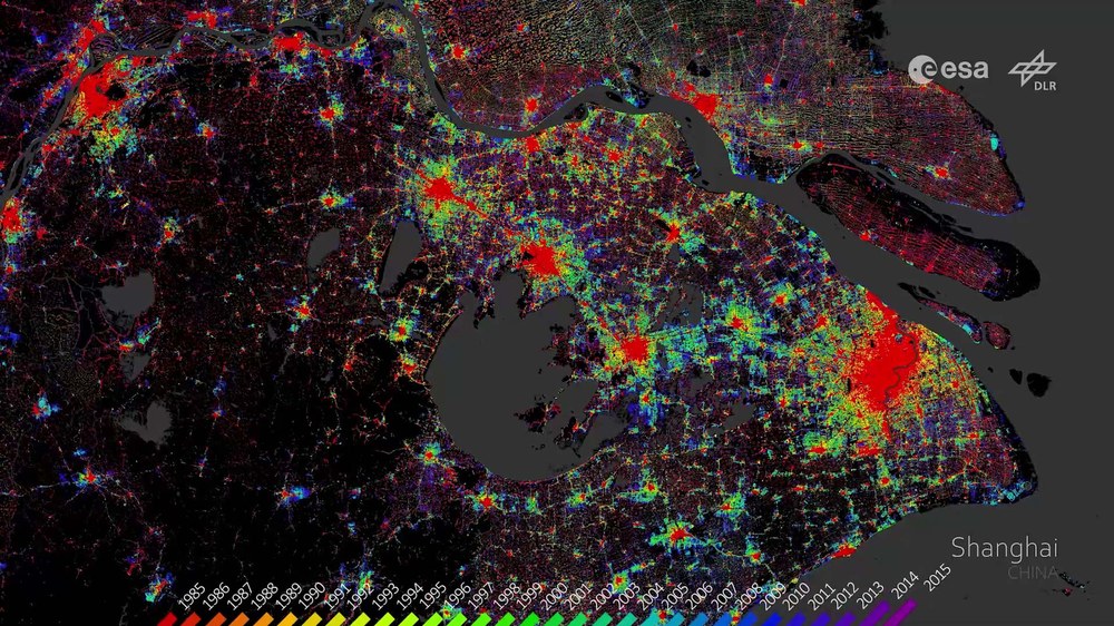
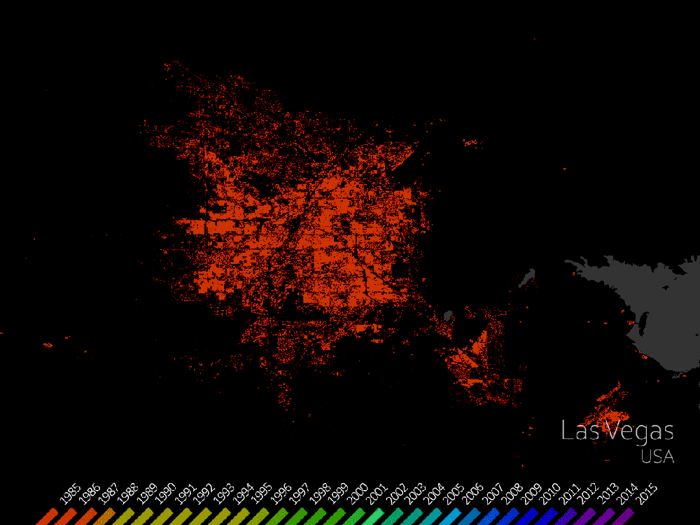
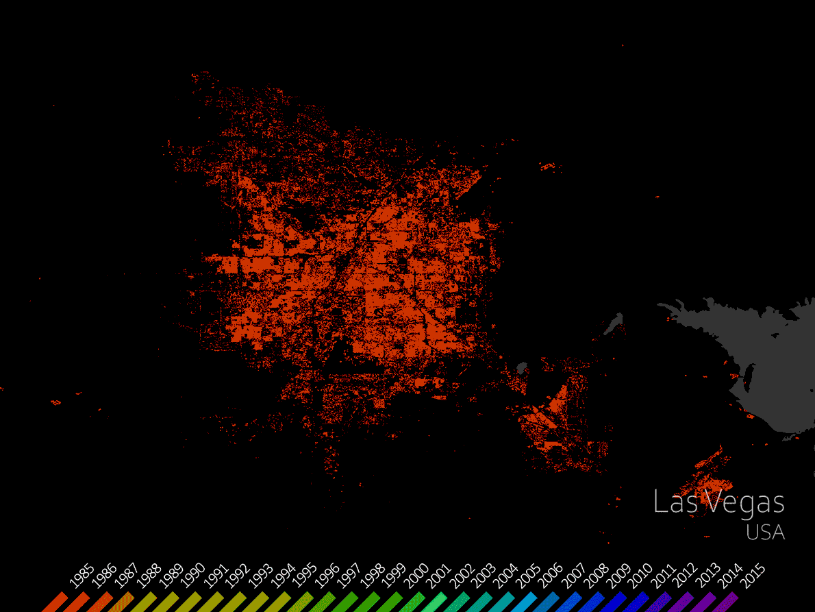
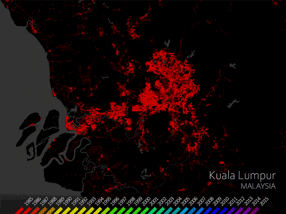
The video shows several examples from the World Settlement Footprint (WSF) Evolution. They illustrate the growth of cities. WSF Evolution uses seven million images from the US Landsat satellite, acquired between 1985 and 2015.
Animation – World Settlement Footprint (WSF) Evolution
Your consent to the storage of data ('cookies') is required for the playback of this video on Quickchannel.com. You can view and change your current data storage settings at any time under privacy.
Animation – World Settlement Footprint (WSF) Evolution
The video shows several examples from the World Settlement Footprint (WSF) Evolution. They illustrate the growth of cities. WSF Evolution uses seven million images from the US Landsat satellite, acquired between 1985 and 2015.
WSF 2019 provides information on settlements with an unprecedented level of accuracy. DLR scientists processed data from the Copernicus satellites Sentinel-1 and Sentinel-2, which map Earth's surface with a resolution of 10 metres. WSF Evolution uses seven million images acquired by the US Landsat satellites between 1985 and 2015. They can be used to track the annual growth of cities. The data can also serve as a basis for sustainable urban development in the future.
"Informed settlement development needs data and the knowledge derived from it about the status and dynamics of the urban system, especially its interactions with the surrounding natural and cultural landscape. The WSF allows us to improve our understanding of such changes on a global level," says Mattia Marconcini of the German Remote Sensing Data Center in Oberpfaffenhofen.
Insights for civil organisations and authorities
The new WSF products are available to civil and governmental organisations and public authorities. In particular, they make analysis of urban growth possible for the first time in developing countries, which previously often had zero or insufficient data. "If you want to know where people live, then you can already get a lot of information from freely accessible web services. However, if you look at rural and suburban areas in low- and middle-income countries, you will notice straight away that there is no information about the overall extent of human settlements for much of the world. We are now offering this data with the WSF," explains Marconcini. WSF 2019 and WSF Evolution are already being used by several international institutions, including the World Bank and UN-Habitat, the United Nation's Human Settlements Programme.
"The availability of continuous data streams of high quality and free of charge satellite observations such as the Sentinels of the European Copernicus programme and the Landsat missions, in combination with the emergence of automated methods for big data processing and data analytics, and the democratisation of computing costs, offer unprecedented opportunities to efficiently monitor the changes and trends in urban development globally," says ESA's Marc Paganini. "The World Settlement Footprint is a great example of how we can mobilise the data revolution for the benefit of all countries and cities, leaving no one behind, which is one of the guiding principles of the 2030 Agenda for Sustainable Development."
Cities are currently growing at a rapid pace, especially in Asia and Africa. Extensive urban landscapes are being formed and entire stretches of land are being overdeveloped. This leads to numerous questions. To what extent do cities damage the environment, for example through resource consumption, air and water pollution or the loss of biodiversity? How severely are the cities themselves threatened by natural hazards and climate change? How have cities developed in the past and how can they be made sustainable? More products will be released in the WSF suite over the coming weeks. In future, WSF Imperviousness will provide information on the prevalence of sealed surfaces. For the first time, WSF 3D will depict the height, density and volume of buildings globally and forms the basis for WSF Population, which will describe the distribution of the population on Earth much more precisely than was previously possible.
The WSF products can be used free of charge via the EOC Geoservice as an interactive visualisation service and for download: WSF Evolution, WSF 2019

