Blown by the wind – the Medusae Fossae Formation on Mars
February 23, 2022 | Mission Mars Express
Blown by the wind – the Medusae Fossae Formation on Mars
Landscape shaped by the wind in Eumenides Dorsum
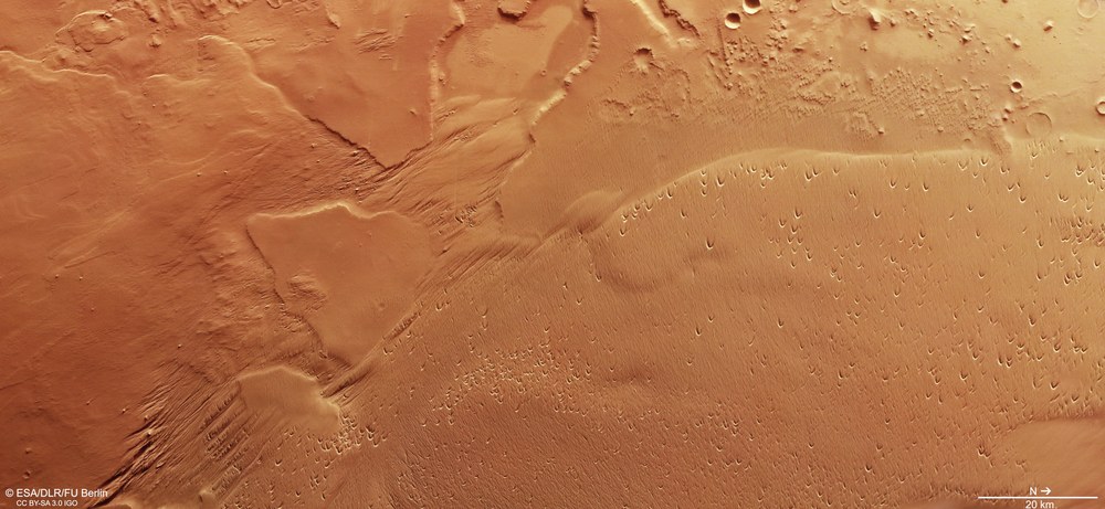
Since January 2004, the High Resolution Stereo Camera (HRSC) operated by the DLR Institute of Planetary Research on board ESA's Mars Express orbiter has been mapping Mars in high resolution, in colour and in '3D'. In the images, generated using data acquired on 14 May 2021 during orbit 21,948, have a resolution of approximately 19 metres per pixel. The landscape is characterised by long-term wind erosion. In the centre of the image, numerous parallel ridges and troughs, known as yardangs and wind gullies, can be seen. Numerous 'blowouts' – saucer- or trough-shaped depressions created by wind erosion of pre-existing sand deposits – can be seen in the area to the right of the image. North is on the right of the image. The size of the area in the image is approximately 180 by 80 kilometres.
Oblique perspective view of a landscape near Eumenides Dorsum
Digital terrain models generated using data acquired by the stereo image channels of the HRSC camera system on ESA's Mars Express orbiter can be used to create perspective views of the Martian landscape. This image shows a view of a landscape near the Eumenides Dorsum mountain range, part of the Medusae Fossae Formation. Here, the wind has acted on an easily erodible surface for a long time. This has created 'yardangs' and wind gullies – ridges and troughs 'carved out' by the wind – as well as 'blowouts' – depressions with an accumulation of sand in the shape of a crescent – which allow conclusions to be drawn about the prevailing wind direction.
Anaglyph images can be generated using data acquired by the nadir channel of the DLR-operated HRSC camera system on ESA's Mars Express orbiter, which is directed perpendicularly to the surface of Mars, and one of the four oblique stereo channels. When used with red-blue or red-green glasses, they provide a three-dimensional view of the landscape. North is to the right in this image. The topography of the landscape, which is strongly influenced by the wind, is clearly visible. In the north, on the right of the image, numerous 'blowouts' can be seen. These are rounded depressions with a crescent-shaped accumulation of sand around them. The left half of the image is characterised by numerous parallel troughs that have been 'carved out' by the wind as if using a sandblaster.
Images from DLR's High Resolution Stereo Camera show a landscape around the mountain range Eumenides Dorsum in the Medusae Fossae region, which is strongly influenced by the wind. Wind has been the most significant force reshaping the surface of the Red Planet for two billion years.
For 19 years, the DLR-developed stereo camera HRSC on board ESA's Mars Express mission has been mapping Mars in high-resolution, colour and in 3D.
Focus: Space exploration, Solar System exploration, Mars
These images, created using data acquired by the High Resolution Stereo Camera (HRSC) on board ESA's Mars Express orbiter, show a landscape formed as a result of intense wind erosion. It is located on the Eumenides Dorsum mountains, a north-south oriented mountain range on Mars. This is an impressive example of the erosive effects of wind on Mars, which has been the most significant force involved in reshaping the surface of the Red Planet for two billion years.
HRSC was developed by the German Aerospace Center (Deutsches Zentrum für Luft- und Raumfahrt; DLR) and is operated by its Institute of Planetary Research in Berlin-Adlershof. Since 2004, it has been mapping Mars in high resolution, in three dimensions and in colour. The data acquired by HRSC are an important resource for current and future Mars research. The findings already obtained in the course of the mission have greatly changed researcher's theories about the geological evolution of the Red Planet.
The Medusa Fossae on the 'back' of the goddesses of vengeance
The Eumenides Dorsum mountain range is named after the vengeful goddesses in Greek mythology, the Eumenides – also known as the Furies – and is part of the Medusae Fossae Formation (MFF). This extends over 5000 kilometres between the volcanic centres around Tharsis and Elysium, along the highland-lowland boundary Martian dichotomy), and has a surface area comparable in size to India. The word fossae, Latin for trenches, indicates that tectonic processes also played a role in shaping the landscape here. The rigid crust was stretched by rising magma bubbles. In the process, it broke open, giving rise to the formation of numerous tectonic grabens.
The MFF seems to consist of easily erodible materials. These are probably pyroclastic flows that originated from the volcanoes of the Tharsis region or Olympus Mons approximately 3.8 to 3 billion years ago (in the Hesperian period). These deposits are formed when red-hot rock fragments ejected by volcanoes are bonded together in a mixture of hot gases and ash to form more or less solidified rock such as tuff and pumice. However, these volcanic deposits do not have a high density and are therefore relatively prone to erosion.
Yardangs and blowouts – evidence of long-term wind erosion
In general, the surface features of the formation in this area of about 180 by 80 kilometres are smooth and gently undulated, as can be seen in the upper left part of images 1, 5 and 6 . In other regions, the wind has formed narrow ridges and troughs, sometimes kilometres long, running parallel to each other. The narrow ridges are known as yardangs and have been carved out of the rock by the grains of sand carried by the wind, as if someone had used a sandblaster. If the wind blows in the same direction over a longer period of time, the elongated troughs can also form wind gullies, in which the wind is accelerated as if by nozzles, ultimately intensifying the erosion process. Yardangs are clearly visible as small, streamlined ridges in the upper centre of the oblique perspective images and in the lower left part of images 1, 5 and 6. These structures bear a strong resemblance to desert features in Central Asia, where they were first described in in 1902 in the Lop Nor desert by the Swedish explorer Sven Hedin after his expedition. The Uyghur word for these landforms has thereby become part of the scientific terminology.
Dozens of crescent-shaped ridges can be seen, each with a central depression, can be seen in the lower right of the vertical plan views. These depressions, which appear to have been excavated by the wind, are referred to as 'blowouts'. A blowout is a saucer- or trough-shaped depression created by wind erosion of a pre-existing sand deposit and formed together with an adjoining sand accumulation referred to as a depositional lobe or blowout dune. Their formation process is relatively simple – wind transports sand, eroding the soft surface. When this hits a buried object, such as a rock or simply a somewhat resistant sedimentary deposit, the wind is forced to blow around it. This creates a vortex at the front of the obstacle. The wind is then driven downwards, around the obstacle and then upwards again, creating a depression as the sand is lifted from the base of the obstacle and deposited behind it.
Only a few craters are found in this area. This is an indication that wind erosion was the most recent change process after the deposition of MFF to have affected the surface here. In the upper right of the perpendicular images, some impact craters can be seen, revealing the underlying older rocks that were covered by the MFF. The MFF is thought to be the largest sediment deposit on the planet as well as the largest single source of dust on Mars.
Image processing
These images were created using data acquired by the High Resolution Stereo Camera (HRSC) on 14 May 2021 during orbits 21,948 of the Mars Express spacecraft. The image resolution is approximately 19 metres per pixel. The centre of the image is located at approximately 192 degrees east and 2 degrees north. The perpendicular colour view was generated using data acquired by the nadir channel, the field of view which is aligned perpendicular to the surface of Mars, and the colour channels of HRSC. The oblique perspective views were computed using a Digital Terrain Model (DTM) and data acquired by the nadir and colour channels of HRSC. The colour-coded topographic view is based on a DTM of the region from which the topography of the landscape can be derived. The reference body for the HRSC DTM is a Martian equipotential surface (areoid).
The HRSC was developed and is operated at the German Aerospace Center (DLR) in cooperation with German industry. The systematic processing of the camera data was performed at the DLR Institute of Planetary Research in Berlin-Adlershof. Personnel in the Department of Planetary Sciences and Remote Sensing at Freie Universität Berlin used these data to create the image products shown here.
The HRSC experiment on Mars Express
The High Resolution Stereo Camera (HRSC) was developed by the German Aerospace Center (Deutsches Zentrum für Luft- und Raumfahrt; DLR) and built in collaboration with partners in industry (Airbus, Lewicki Microelectronic GmbH and Jena-Optronik GmbH). The science team, which is headed by Principal Investigator (PI) Thomas Roatsch, consists of 50 co-investigators from 34 institutions in 11 countries.


