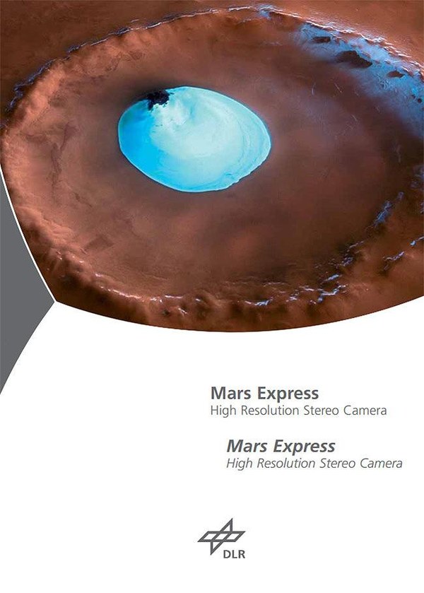
Water ice at the bottom of a crater near the Martian north pole. In the centre of the crater, which is about 35 kilometres across, white water ice stands out clearly. The impact crater is located in the northern lowland area Vastitas Borealis. Water ice can remain in the centre of the crater throughout the year, as the temperature is low enough and atmospheric pressure is sufficient to prevent sublimation (direct transition from a solid to a gaseous state). At the time of image acquisition (later summer on Mars), carbon dioxide ice had already disappeared from the entire northern polar cap, leaving only water ice. The thickness of the ice is probably only in the decimetre range. This has been confirmed by some earlier measurements. Copyright note: As a joint undertaking by DLR, ESA and FU Berlin, the Mars Express HRSC images are published under a Creative Commons licence since December 2014: ESA/DLR/FU Berlin, CC BY-SA 3.0 IGO. This licence will also apply to all HRSC images released to date.
Discoveries made during previous missions to Mars have shown that, before a climate change about 3000 million years ago, this was a warm and humid planet. Mars Express obtains information about the history of the Red Planet’s climate by carrying out global reconnaissance from orbit. This should clarify questions relating to the existence of water on the planet and how long it was there, if at all. It is hoped that by using comparative planetology, scientists will be able to establish parallels between Mars and Earth, allowing them for example to make more accurate statements about the long-term development of our own planet.
The Mars Express Orbiter's tasks:
globally map the surface of Mars, both topographically and morphologically, with a nominal resolution of 10 metres in all three dimensions, and take telephoto images with a resolution of up to 2 metres
create geological and mineralogical maps by taking multi-coloured images
analyse atmospheric processes and composition
study the subterranean structure (particularly in the search of permafrost)
study the interaction between the planet's surface and the atmosphere
study the interaction between the atmosphere and the interplanetary medium
The Beagle 2 lander was designed to:
study the meteorology and climatology of the planet
investigate the geology, mineralogy and geochemistry at the landing site
analyse the physical properties of the atmosphere and surface layers
look for traces of life (exobiology)
The Beagle 2 landing spacecraft has been declared lost.

