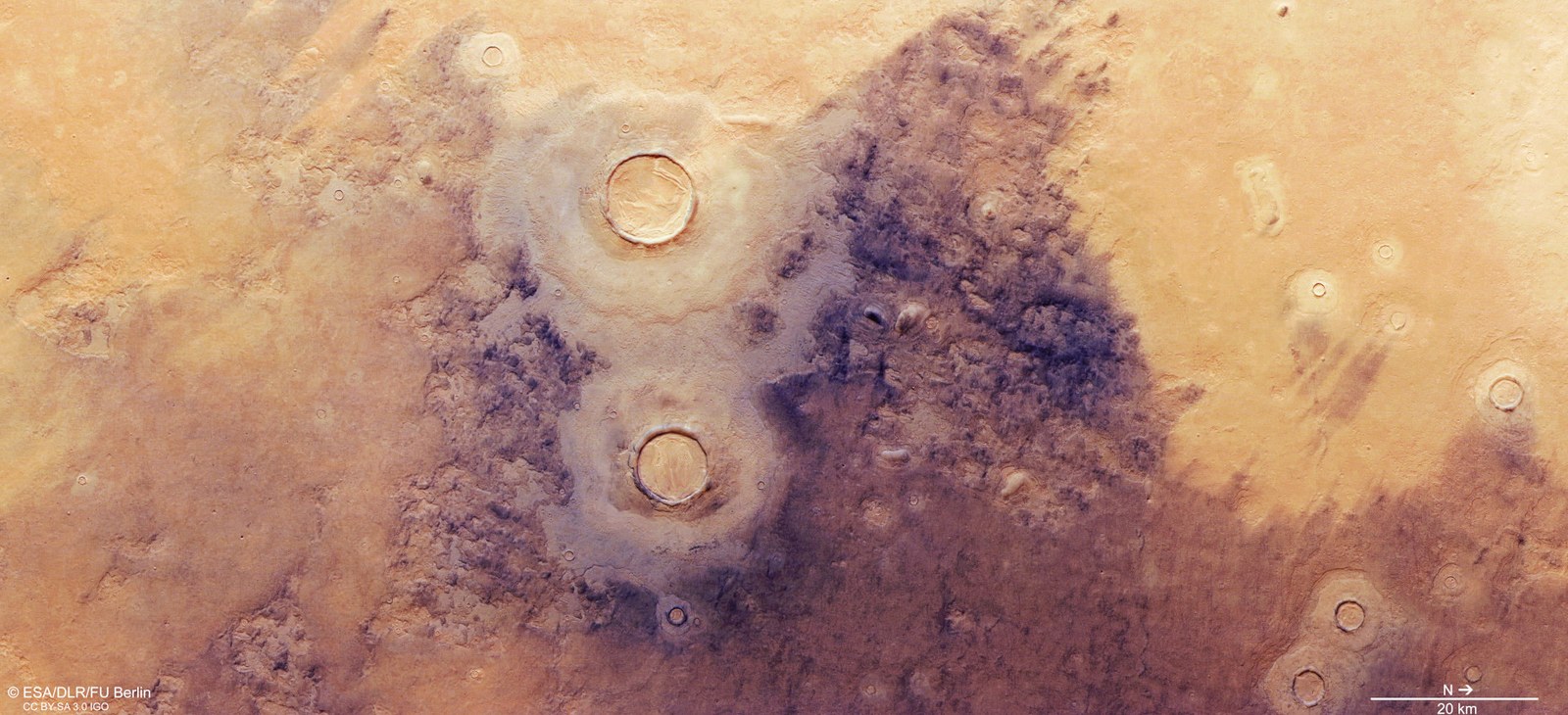
Vertical plan view of a section of Utopia Planitia
The periodic tilting of the planet's axis of rotation by up to 60 degrees causes strong fluctuations in the martian climate. Even in temperate latitudes, which on Earth would correspond to geographic regions such as Europe, this tilting means that ice is deposited over long periods of time. Together with the dust carried in by the wind, the ice forms layers that cover existing surface formations like a cloak. In this contrast-enhanced aerial view, these 'mantle deposits' can be seen on the left and right thirds of the image (north is on the right of the image). Crater ejecta covers the area in two layers to the left and right of the two 10- and 12-kilometre impact craters in the centre of the image. Mantle deposits can be seen on the crater rims and are particularly clear inside the impact craters. Here, it is referred to as 'concentric crater fill' and is also found in the smaller craters in the area.
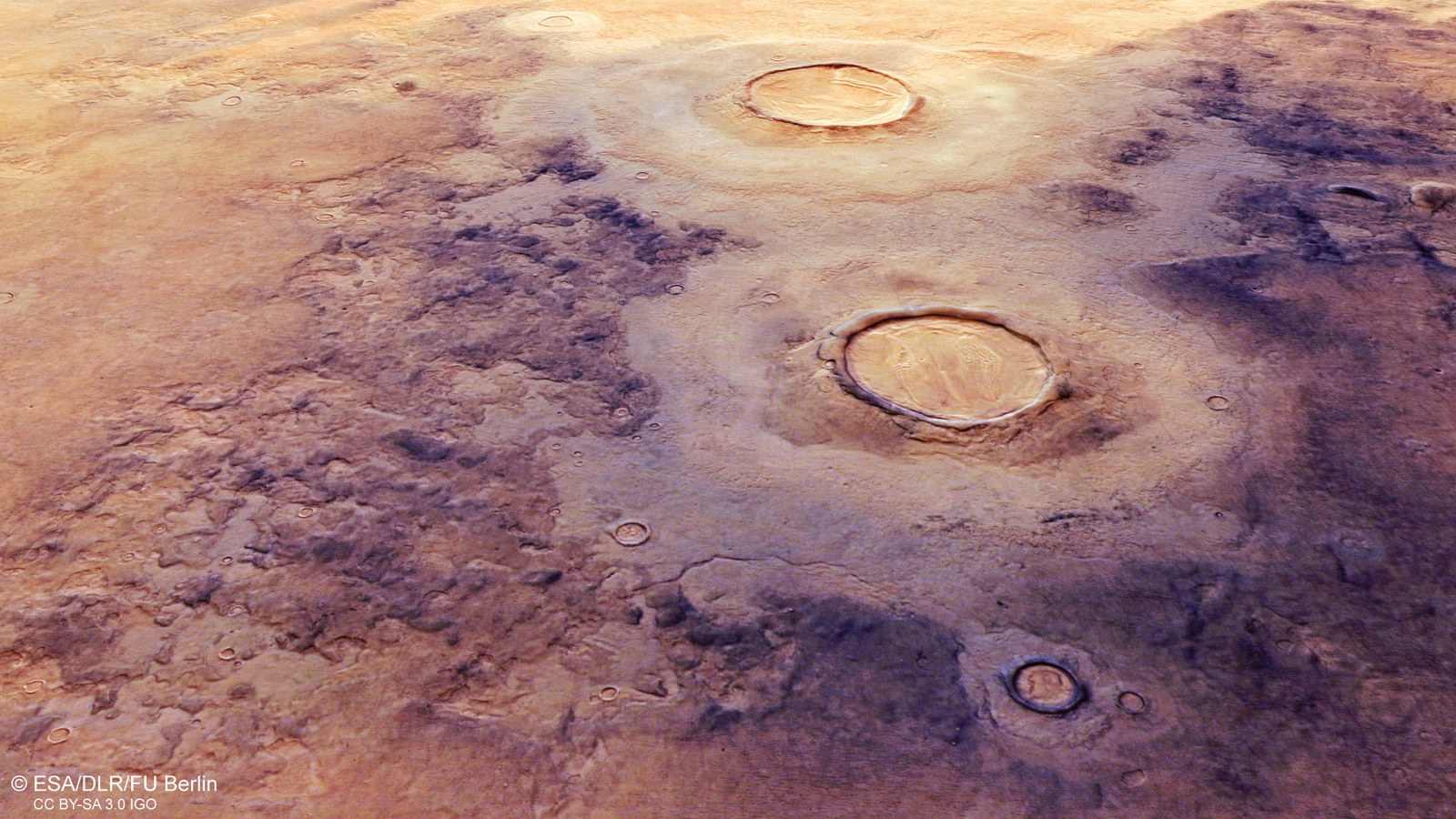
Digital terrain models generated using data acquired by the stereo image channels of the HRSC camera system on ESA's Mars Express orbiter can be used to create perspective views of the Martian landscape. Subtle differences in material and texture have been made more apparent by enhancing the contrast in the colour data. The two impact craters in the centre of the image, which measure 10 and 12 kilometres across, show a double-layered blanket of ejecta. On closer inspection, individual layers of mantle deposits can be seen on the slopes of the many smaller depressions on the left of the image, where erosion has breached the previously closed mantle covering. The crater infill, which is also layered, indicates a mixture of ice and dust that has collapsed in the middle of the crater, giving it a concentrically lined surface texture.
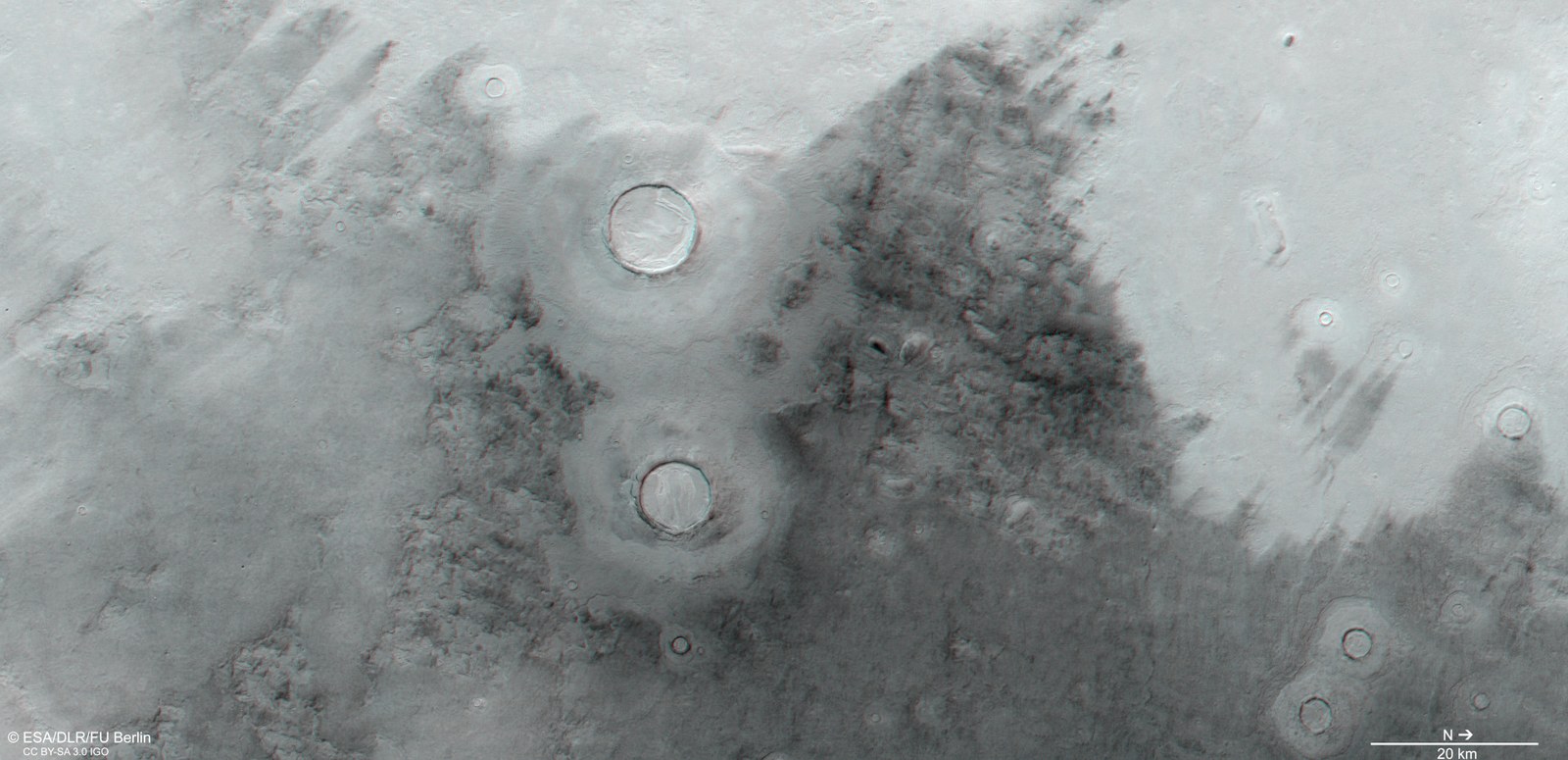
Anaglyph images can be generated using data acquired by the nadir channel of the DLR-operated HRSC camera system on board ESA's Mars Express orbiter, the field of view of which is directed perpendicularly to the surface of Mars, and one of the four oblique stereo channels. When used with red-blue or red-green glasses, they provide a three-dimensional view of the landscape. North is to the right in this image. The topography of the landscape – the differences in the height of the surface formations shaped by ice and wind – can be seen more clearly here than in the coloured plan view, in particular the thermokarst textures of the infill in the two 12- and 10-km craters in the centre of the image.
Ice has shaped the landscapes of Mars' vast northern lowlands.
These regions are the legacy of a time when Mars' axis of rotation was much more inclined than it is today, leading to extreme climate fluctuations.
These images of a landscape in Utopia Planitia were acquired by the DLR-developed HRSC stereo camera during orbit 22,150 of ESA's Mars Express spacecraft.
The HRSC has been mapping Mars at high resolution, in three dimensions and in colour since 2004. The data that it provides are an important resource for Mars research both now and in the future.
Focus: Space exploration, planetary research, Mars
These images were created using data acquired by the High Resolution Stereo Camera (HRSC), which was developed at the German Aerospace Center (Deutsches Zentrum für Luft- und Raumfahrt; DLR) and is operated by the DLR Institute of Planetary Research in Berlin-Adlershof. They show a landscape in Utopia Planitia that is millions of years old and was shaped by ice. Utopia is one of three major topographical depressions in the northern hemisphere of Mars and measures 3300 kilometres across. The basin was probably created approximately four billion years ago by the impact of an asteroid that may have been over 200 kilometres in diameter. Over time, the impact basin, which was initially several kilometres deep, has filled up with sediments and ice that were transported there by wind and water, as well as with lava from low-viscosity volcanic eruptions. In the area of Utopia shown here, it is primarily thick layers of ice and dust that have blanketed the existing topography, creating this almost impressionistic landscape.
Utopia – based on an ancient Greek term meaning 'no place' or 'nowhere', or a place that exists only in the imagination – is the largest recognised impact basin on Mars; larger even than the far more striking impact formation Hellas Planitia in the southern highlands. NASA's Viking 2 spacecraft landed in Utopia on 3 September 1976, a few hundred kilometres to the east of the landscape shown here. Alongside its sister spacecraft Viking 1, which landed in Chryse Planitia, it explored Mars for three and a half years. These were the first spacecraft to conduct such missions on the Martian soil. During the winter, Viking 2 transmitted images to Earth showing rocks covered with hoarfrost after cold nights – which caused a scientific sensation at the time.
'Tilted Mars' – an ice machine
There was probably much more ice in Utopia Planitia 10 million years ago, as the planet's axis of rotation was tilted much more back then, leading to cyclical changes in the Martian climate. Unlike Earth, Mars' inclination changes significantly on timescales ranging from hundreds of thousands to millions of years. The inclination of Mars' axis of rotation today, at 25.2 degrees (compared to Earth’s 23.3 degrees), means that ice is present in relatively modest amounts at the north and south poles. Ten million years ago, however, the axis could have been tilted as much as 60 degrees from the orbital plane, resulting in much more extreme climate variability – with ice in Utopia Planitia being one of the consequences.
This resulted in the mantled deposits shown here. These are thick, ice- and dust-rich layers thought to have been deposited 10 million years ago as snow mixed with wind-blown dust. This mixture of dust and ice covers and smooths out the surface like a cloak. This can be seen very well in the large patches on the left and right of the vertical plan view (Image 1). The two impact craters in the centre of the image, which measure 10 and 12 kilometres across, show a double-layered blanket of ejecta. On closer inspection, the stratified appearance of the mantle deposits can be seen at the crater rims and particularly well inside the impact craters. Here it is referred to as 'concentric crater fill' and is also found in the smaller craters in the area.
Shrinkage cracks filled with dark dust
The second largest crater in the centre of the images shows a typical texture of sinuous, concentrically deformed deposits on the mantle cover, vaguely reminiscent of a brain. They developed curved indentations through gradual ageing and erosion, including through the direct evaporation of ice. A pattern is faintly visible in the dark-coloured regions just to the right of this crater. This was formed when the surface cracked due to cooling and thermal contraction, leaving a polygonal pattern in the ground. Dark, wind-blown dust deposited in the cracks is responsible for the dark colouring of this region.
Curved, sediment-filled depressions are visible throughout the image. These can be circular to elliptical and measure anywhere from a few tens of metres to several kilometres in size and be up to tens of metres deep. They are the result of the melting or evaporation of ice underground, followed by the collapse of the surface. The process of subsidence due to ice loss in the subsurface is referred to as thermokarst.
A closer look reveals stratification of the mantle deposits in and around the curved depressions. Radar measurements, which can detect layer boundaries between ice lenses and rock, and spectrometry, which can measure the abundance of hydrogen, have detected water ice in the soil of the northern lowlands. This has been confirmed by NASA's Phoenix lander (2009). Ice has been discovered at greater depths by observations of fresh impact craters and depressions, and also in numerous other locations using radar soundings.
Image processing
These images were created using data acquired by the High Resolution Stereo Camera (HRSC) on 12 July 2021 during Mars Express orbit 22,150. The image resolution is approximately 19 metres per pixel. The centre of the image is located at approximately 83 degrees east and 43 degrees north. The colour plan view was created using data acquired by the nadir channel, the field of view of which is aligned perpendicular to the surface of Mars, and the colour channels of HRSC. The oblique perspective views were computed using a terrain model and data from the HRSC nadir and colour channels. The colour-coded topographic view is based on a Digital Terrain Model (DTM) of the region from which the topography of the landscape can be derived. The reference body for the HRSC DTM is a Martian equipotential surface (Areoid). The systematic processing of the camera data was carried out at the DLR Institute of Planetary Research in Berlin-Adlershof. Personnel in the Department of Planetary Sciences and Remote Sensing at Freie Universität Berlin used these data to create the image products shown here.
The HRSC experiment on Mars Express
The High Resolution Stereo Camera (HRSC) was developed by the German Aerospace Center (Deutsches Zentrum für Luft- und Raumfahrt; DLR) and built in collaboration with partners in industry (Airbus, Lewicki Microelectronic GmbH and Jena-Optronik GmbH). The science team, which is headed by Principal Investigator (PI) Thomas Roatsch, consists of 50 co-investigators from 34 institutions in 11 countries.
