A complex Martian landscape in the 'Land of the Sirens'
October 26, 2022 | Mars Express mission
A complex Martian landscape in the 'Land of the Sirens'
Vertical plan view in true colour
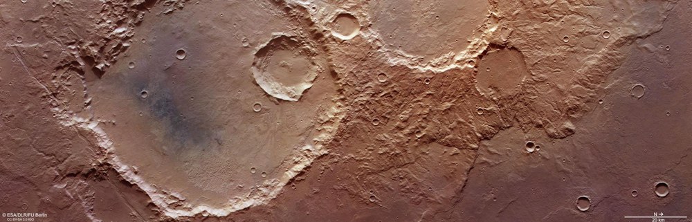
An area approximately 220 by 70 kilometres southeast of Pickering Crater (outside the scene) in the Terra Sirenum region shows many landscapes that are typical of the ancient Martian highlands. These include features that are over three billion years old and thus heavily eroded, and a sediment-filled impact crater measuring 115 kilometres across. Also clearly visible are valleys formed by running water and debris-laden rock glaciers slowly creeping over the surface, solidified and superimposed lava flows, tectonic fault struc-tures and features created more recently by wind erosion. North is to the right of the im-age.
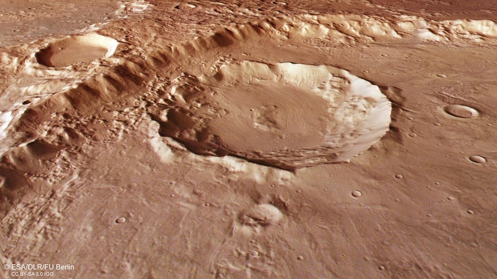
This crater is located to the north of the large crater in the scene observed by the HRSC Mars camera. The difference in altitude from the highest point of the crater rim to the lowest point is almost 1500 metres. To the north, the crater rim has experienced much stronger erosion, due to material falling from the rim of the larger crater in the back-ground, which is located a further 1000 metres above the rim of the smaller crater. Within the crater are deposits interspersed with meandering lines – the remnants of glaciers that once flowed into the crater and met at its centre. They are referred to as lobate crater fill – glaciers whose ice flow is covered by rock debris, and are also known as rock glaciers.
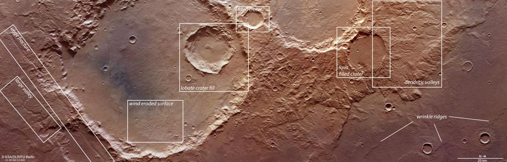
This area in the ancient southern Martian highlands, measuring 220 by 70 kilometres, was imaged by the DLR HRSC camera system on ESA's Mars Express orbiter on 5 April 2022 and shows several geological landforms that are described in the text that accompanies these images. From left to right: a river valley carved into the highlands by water flowing down-hill ('large valley'); a tectonic rift or large fracture; 'wind alleys' carved into the landscape by dust and sand ('wind-eroded surface'); lobate crater fill ('crater fill') left by rock glaciers; a crater filled with thin, solidified lava ('lava-filled crater'); a dense network of valleys eroded into the landscape by run-off rainwater, snow and ice ('dendritic valleys'); and wrinkle ridges of lava surface material that has been pushed together.
Image data from DLR's High Resolution Stereo Camera (HRSC) on board ESA's Mars Express mission show a diverse region southeast of the Pickering crater in Terra Sirenum.
In the images, a crater about 70 kilometres in diameter dominates the scene.
The eastern crater floor features interesting landscape forms that are the re-sult of wind erosion.
In the smaller impact crater in the northern part of the large crater, you can see deposits criss-crossed with lines – the remains of former glaciers that flowed down the crater slopes.
A different appearance can be seen in an impact crater further north: here the surface indicates that it was filled with thin lava.
Image data from the High Resolution Stereo Camera (HRSC) operated by the German Aerospace Center (Deutsches Zentrum für Luft- und Raumfahrt; DLR) aboard the ESA Mars Express mission show a diverse region southeast of the Pickering Crater in Terra Sirenum on the boundary with Daedalia Planum. Terra Sirenum (Land of the Sirens) is a vast highland region over 3.5 billion years old in the southwest of the Tharsis volcanic region. Here – and in the southern highlands in general – there are more impact craters on the surface than in the northern lowlands.
The large variety of surface structures can be attributed to a number of processes. The HRSC images acquired on 5 April 2022 (orbit 23,067) tell a complex geological story: the ground resolution of the image data is approximately 15 metres per pixel. The centre of the image is at 232 degrees east and 38 degrees south. Although Pickering, a prominent crater, is not visible in the HRSC images, is has been included in the regional overview map, in the northwest area of the section shown. This 115-kilometre-diameter crater is rather unusual among Mars craters, as it was named after three people: the US astronomer and physicist Edward Charles Pickering (1846–1919), his brother William Henry Pickering (1858–1938), also an astronomer, and the New Zealand-born rocket engineer and former director of NASA's Jet Pro-pulsion Laboratory, William Hayward Pickering (1910–2004).
A nameless crater approximately 70 kilometres across dominates the landscape in the images displayed. A valley measuring up to 1.8 kilometres across snakes across the landscape in the bottom left, southeast of the crater. Meltwater from the sur-rounding highlands could have flowed into the valley, having run into the depression beneath the crater basin (at the bottom edge of the image). Just 10 kilometres to the north of the valley is fracture that runs almost parallel to it and cuts through the southern edge of the basin. Large, canal-like fractures like this are described as tec-tonic grabens. They occur in regions that are subject to tectonic expansion, where the bedrock is pulled apart by stresses in the brittle crust, so that it cracks along the zone of weakness and drops downward between the two fault lines. These features, which are typical of tectonic grabens, occur in many locations on Mars, such as the south-eastern grabens of Icaria Fossae.
Surface structures indicate ice streams
A large impact crater fills the centre of the image. The traces of erosion here indicate that it is extremely old. At its heart is a region that is dark in places. The dark colour-ing is due to a thin layer of volcanic sands that have been carried into the crater by the wind and deposited there. The floor of the crater is very flat and has long ceased to be bowl-shaped, as would have been typical of the indentation made by a 5–10-kilometre asteroid shortly after it hit the planet. This infilling is another indication of the crater's considerable age. Intriguing landscape features due to wind erosion can be seen at the lower (eastern) edge of the crater floor. It has countless small hills that the wind has scoured out of the rock, along with a few elongated ridges all run-ning in the same direction. The latter are called yardangs. The wind, which is some-times very strong on Mars and blows in one direction for long periods of time, scours 'wind alleys' into the rock due to the dust and sand particles it carries. These indicate the dominant wind direction. The long, thin structure than runs transversely is highly likely to be a former valley filled with erosion-resistant material.
Lava-filled craters and branching valleys
A small impact crater measuring just 20 kilometres across is located in the northern (right-hand) part of the large crater. Deposits cut through by lines can be seen within the crater. These are the remains of former glaciers that flowed down the crater slopes and met in the middle. They are marked as 'lobate crater fill' in the annotated plan view. The surface in the immediate vicinity to the north and in the small neighbouring craters is flat and appears smooth, resembling glaciers on Earth where the ice stream is covered by rock debris. In glaciology, such ice streams are called rock glaciers. These flow structures are formed when a mixture of debris and ice flows downhill from a glacier, and the debris then traces the movements of the ice flow, which becomes malleable under the weight of the rock and the pressure exerted by own weight. Such flow structures are clearly visible in the perspective view of the crater.
An old impact crater further north – labelled 'lava-filled crater' in the plan view, has a completely different appearance. Here, the surface suggests a filling of thin lava that has flowed into the bowl-shaped crater structure. The surface pattern differs from the 'periglacial' features typical of polar landscapes – the processes and landforms associated with cold regions that are not covered in ice. Adjacent to the north is a large network of heavily eroded, branching valleys. These ‘dendritic’ valley patterns are typically formed on Earth by the run-off of surface rainwater, so researchers as-sume that these valleys were formed relatively early in Martian history by atmospher-ic precipitation (probably snow rather than rain).
Finally, in the bottom right – northeast on the top view – is a large lava field. Wrinkle ridges are visible here. These are formed when, for instance, layered surface mate-rial (in this case, a soft, pliable layer of lava) is compressed by tectonic forces, and its surface area is reduced. These ridges are very typical of lava deposits on Mars and on the Moon. The steeper side of the ridges, which ascend several dozen me-tres, marks their front side, where the material arched upwards and over the 'over-run' lava layer. These landforms all demonstrate the complex history and formation of Mars in a single image.
Image processing
The images shown here were created using data acquired by the High Resolution Stereo Camera (HRSC) on 5 April 2022 during orbit 23,067 of the Mars Express spacecraft around the Red Planet. The image resolution is approximately 15 metres per pixel. The centre of the images is located at approximately 232 degrees east and 38 degrees south. The colour view was created using data from the nadir channel, the field of view of which is directed perpendicular to the Martian surface, and the colour channels of HRSC. The oblique perspective views were computed using data from the stereo channels of HRSC. The anaglyph image which gives a three-dimensional impression of the landscape when viewed with red-blue or red-green glasses, was created using data from the nadir channel and stereo channels. The colour-coded topographic view is based on a Digital Terrain Model (DTM) of the region, from which the topography of the landscape can be derived. The reference body for the HRSC DTM is an equipotential surface of Mars (areoid). The systematic processing of the camera data was carried out at the DLR Institute of Planetary Research. Personnel in the Department of Planetary Sciences and Remote Sensing at the Freie Universität Berlin used these data to create the image products shown here.
The HRSC experiment on Mars Express
The High Resolution Stereo Camera (HRSC) was developed at the German Aerospace Center (DLR) and built in cooperation with industrial partners (EADS Astrium, Lewicki Microelectronic GmbH and Jena-Optronik GmbH). The science team, led by Principal Investigator (PI) Dr Thomas Roatsch of the DLR Institute of Planetary Research, consists of 52 co-investigators from 34 institutions and 11 nations. The camera is operated by the DLR Institute of Planetary Research in Berlin-Adlershof. These high-resolution images and more images acquired by HRSC can be found in the Mars Express image gallery on flickr.
