100 years since the discovery of Tutankhamun's tomb – discovering the Valley of the Kings with radar
February 16, 2023 | TerraSAR-X and TanDEM-X highlight images
100 years since the discovery of Tutankhamun's tomb – discovering the Valley of the Kings with radar
The Valley of the Kings in the Nile Valley
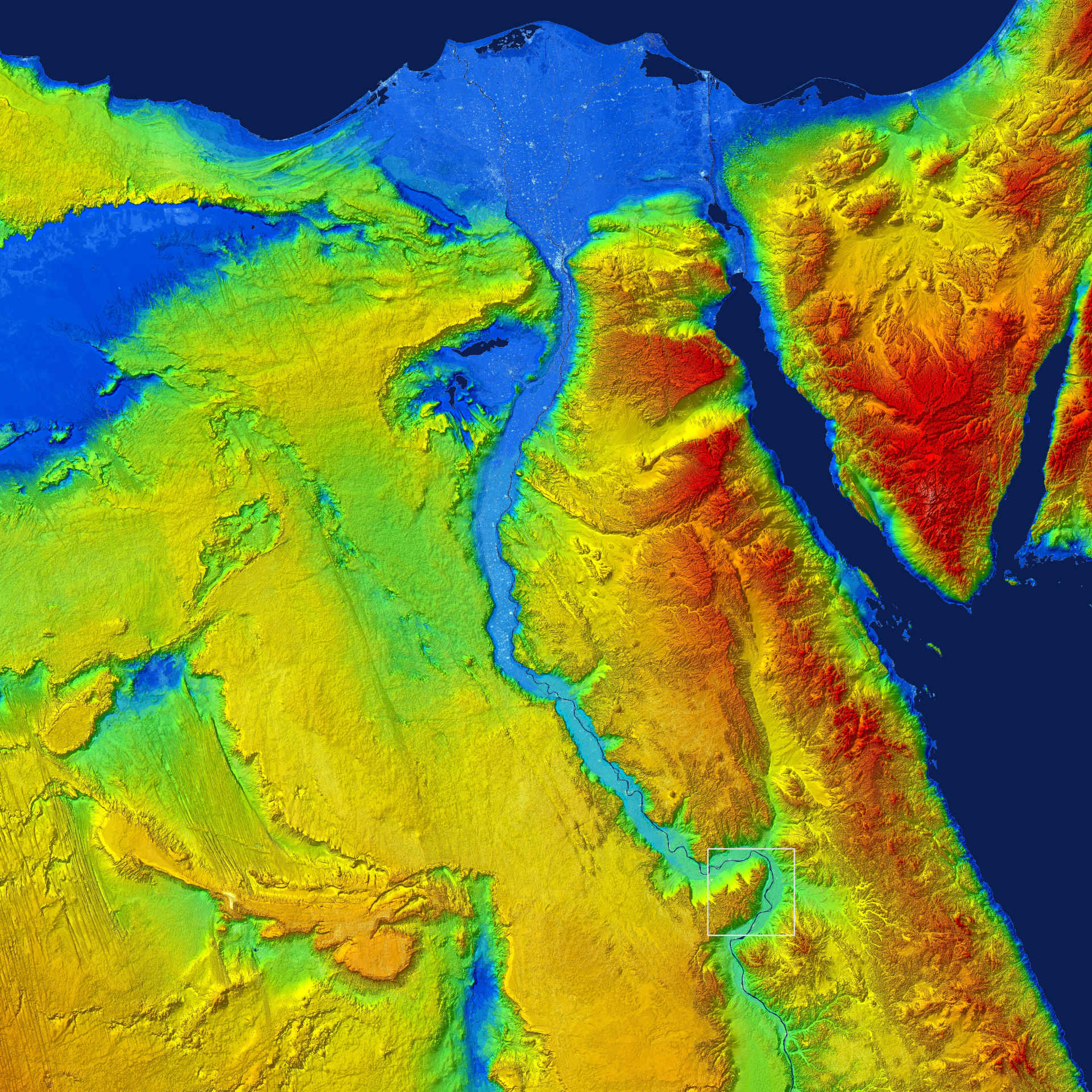
The Nile River snakes deeply through the surrounding plateaus of Egypt. At its northern end, it fans out into a delta that is 250 kilometres wide. The Valley of the Kings lies slightly above the southern end of the picture on the course of the Nile (marked with a white square).This digital elevation model was created using data acquired the two radar satellites TerraSAR-X and TanDEM-X. The image covers an area of approximately 800 kilometres in both north-south and east-west directions.In the image, water areas such as the Red Sea and the course of the Nile River have been coloured in dark blue. Low-lying areas at sea level are light blue and rising terrain is coloured with a gradient from green to yellow to red up to an altitude of approximately 2800 metres.
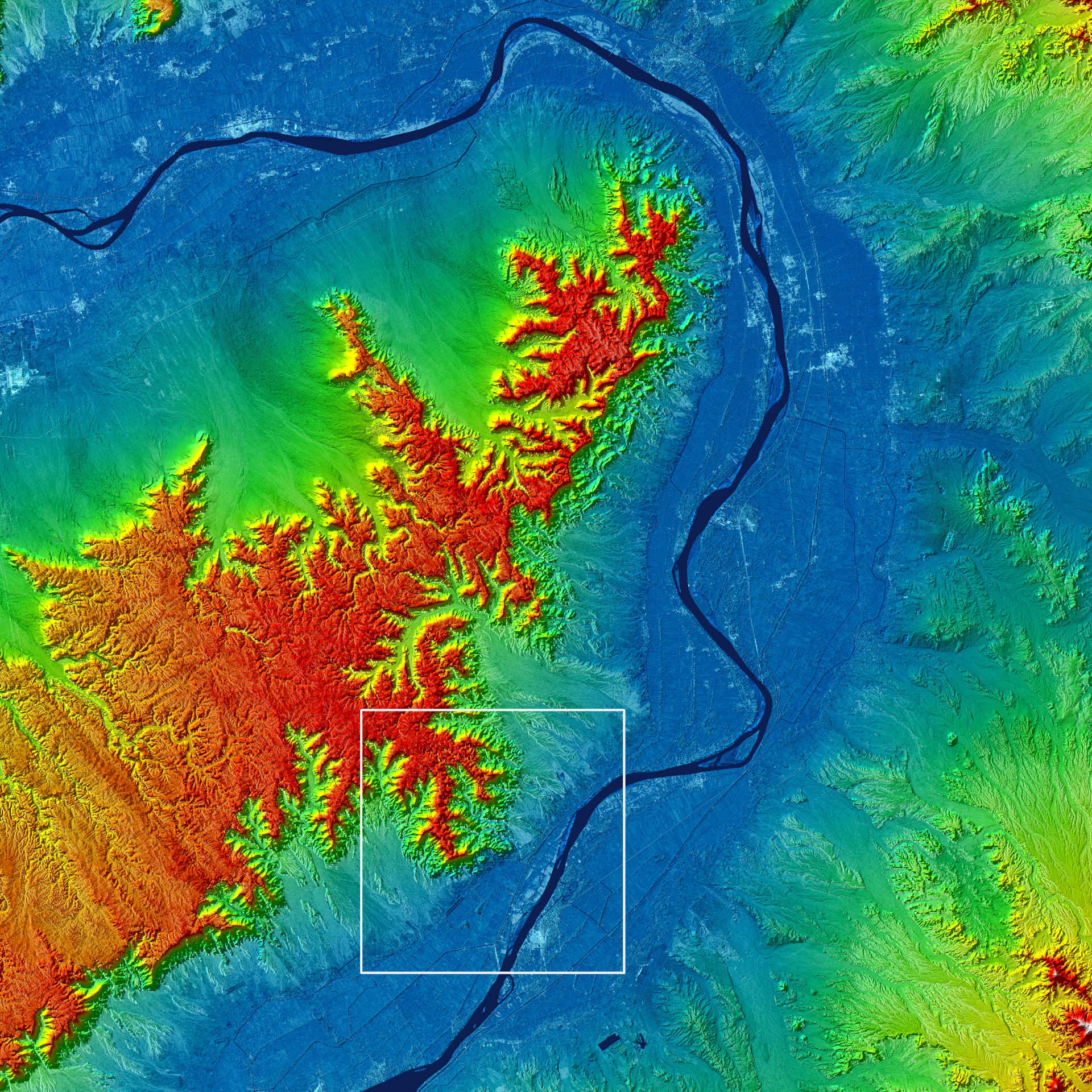
The Valley of the Kings lies in one of the south-eastern side foothills of the Theban Mountains. The city of Luxor is located south of it, recognisable as a bright spot on the south-eastern bank of the Nile.This digital elevation model of the Nile Valley was computed from data acquired by the two radar satellites TerraSAR-X and TanDEM-X.The image covers an area of 64 kilometres in both north-south and east-west directions.In the image, water areas such as the course of the Nile River have been coloured in dark blue. Low-lying areas shown in light blue are approximately 50 metres above sea level and rising terrain is coloured with a gradient from green to yellow to red to an altitude of 500 metres.
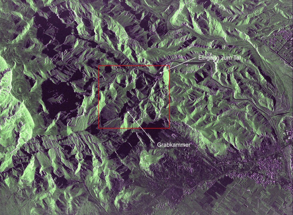
Valley of the Kings with Tutankhamun's burial chamber
The Valley of the Kings is surrounded by steep rock faces. This is revealed in the image by the black shadow areas surrounding it. The TanDEM-X satellite acquired this zoom image in November 2022. This 'staring spotlight' image has an extent of four kilometres by five kilometres (flight direction by ranging direction) and a resolution of 31 centimetres by 76 centimetres. It shows the valley and the entrance area in detail. The black areas in the mountains are shadow areas caused by the steep relief of the mountains and the oblique viewing direction of the satellite.
16 February 2023 marks the 100th anniversary of the opening of Tutankhamun's burial chamber.
To mark the occasion, the German radar satellites TerraSAR-X and TanDEM-X have recently acquired images of the Valley of the Kings in Upper Egypt.
Focus: Space, Earth observation
A century ago, the British archaeologist Howard Carter opened Tutankhamun's burial chamber. For years he had been searching for the pharaoh's tomb in the Valley of the Kings, northwest of the Upper Egyptian city of Luxor. Having almost given up, he found Tutankhamun's tomb in the winter of 1922. However, several months of careful preparations were needed before the archaeologist could enter the interior of the burial chamber. On 16 February 1923, Carter and his team finally broke through the door between the antechamber and the burial chamber. Inside they found a treasure trove of almost completely preserved burial objects and the pharaoh's sarcophagus – still a sensational find today.
The German radar satellites TerraSAR-X and TanDEM-X have now made the hidden Valley of the Kings visible in an impressive way. The two satellites orbit the Earth, only a few hundred metres apart, at an altitude of 514 kilometres. This means that they can record the same area on Earth at the same time. Using what is referred to as SAR interferometry, detailed elevation models of Earth can be created from the radar data acquired by the satellites. One of the two satellites transmits radar signals. The signal echoes reflected by Earth's surface are then received by both satellites from two different angles, similar to human stereoscopic vision. From the different path lengths of the signals from the ground to the satellites, the elevation of Earth's surface can be measured during the overflight. The DLR team used these data to create a digital elevation model of the Valley of the Kings. In flat areas, they also enhanced the backscatter from Earth's surface measured by the satellites to make cities, for example, more visible. The model was also colourised for a more vivid representation.
Rich detail through radar
The data from the radar satellites was used to create a Digital Elevation Model (DEM) of the Nile Valley at various magnification levels. The increased zoom levels reveal new structures and details of the mountainous region and the Nile Valley. The Valley of the Kings itself extends over a very small area of one square kilometre and only becomes clearly visible at the highest magnification level (Image 3). It lies to the west of the Nile, in the southern foothills of the highly fissured rock massif of the Theban Mountains. The highest point of the Theban Mountains is the pyramid shaped El Qurn (southernmost ridge in Image 3). At its end are the 64 burial chambers of the pharaohs – among them 'KV62' (King's Valley 62), the burial chamber of Tutankhamun. On the southern slope of El-Qurn is the Valley of the Queens and the magnificent burial temple of the ancient Egyptian queen Hatshepsut.
On the eastern side of the Nile lies the city of Luxor. It is clearly recognisable by the light-coloured structures in Images 2 and 3. In Tutankhamun's time, the city was called Thebes and was mainly used as the most important necropolis, that is, a city of the dead. Approximately in the centre, to the north of the bright centre of Luxor, directly on the Nile, is the Luxor Temple. At its northern end is Karnak, the largest temple complex in Egypt.
The last two pictures show high-resolution SAR images of the valley. In contrast to the digital elevation models, these were acquired using only one satellite. In the fourth image, both the Valley of the Kings and the city of Luxor can be seen. A further close-up in the fifth image shows the valley and the entrance area in detail. Due to the lateral-viewing geometry of the image, the valley appears very three-dimensional in the centre of the image.
TheTerraSAR-X and TanDEM-X missions were realised on behalf of the German Aerospace Center (Deutsches Zentrum für Luft- und Raumfahrt; DLR) with funding from the Federal Ministry for Economic Affairs and Climate Action (Bundesministerium für Wirtschaft und Klimaschutz; BMWK. They are the first German satellites to be realised within the framework of a Public Private Partnership (PPP) between DLR and Airbus Defence and Space GmbH. DLR is responsible for the construction and operation of the ground segment as well as for the scientific use of the data and its distribution to external researchers worldwide. Airbus Defence and Space GmbH contributed to the costs of developing, constructing and launching the satellites. The 'Geo-Intelligence' programme line at Airbus D&S is responsible for the commercial marketing of the data. Since 2016, the project has been continued under a follow-on agreement with Airbus.


