

DLRmagazine 166 – Next stop: the future
10.4 MB | PDF


How are the climate and environment changing? Where and when did it snow last winter? How quickly are settlements and cities growing? What dangers do we face? Satellite images of Germany, Europe and the entire planet can answer these questions – and many more. Every day over 21 tera bytes of data are streamed from Earth observation satellites to DLR’s Earth Observation Center (EOC). There, they are processed into image and informa tion products for use in research. The 29 petabytes of data now stored at the EOC correspond to over 7 million hours of YouTube videos, or 800 years of non-stop film. This would have been completely unimaginable 40 years ago.
At that time, DLR was still the DFVLR – the Deutsche Forschungs- und Versuchsanstalt für Luft- und Raumfahrt (German Test and Research Institute for Aviation and Space flight). Films were shown exclusively on one of the public service channels or at the cinema, Pink Floyd were on tour, Helmut Schmidt was the German Chancellor and the push-button telephone was the latest gadget. Back to the beginning The year 1980 also marked the opening of a new scientific and technological facility in Oberpfaffenhofen: the Applied Data Technology Department, a predecessor of today’s German Remote Sensing Data Center (DFD). Today, the DFD and the DLR Remote Sens ing Technology Institute make up the EOC. One of the first tasks of this new facility was to receive and process data from the TIROS-Satellites, the first spacecraft designed for monitoring and forecasting weather.
In the early days, the only electrical device in the office was a telephone – and even that was one of the old rotary dial models. Drafts, documentation and calculations were all worked out by hand. The department computer was shared; it was operated via an alphanumeric terminal and was connected to a daisy wheel printer. Technologies such as ‘frame synchronisers’ and ‘commu nication elements’, which were intended to receive flows of data from space, generally had to be developed and constructed in-house. They were required as interfaces with the computers, which were not very powerful at the time. One highlight of 1985 was the German Spacelab Mission (D-1). The scientists at the facility, which was still in its infancy, created a ‘data selection unit’ (DSU) for the laboratory on board the Challenger Space Shuttle. This allowed data from the Spacelab to be specifically selected for transmission from the US to Germany; a transmission of the entire data stream via satellite was still far too expensive.
Meanwhile, in Neustrelitz, on the other side of the divided Germany, the Institute of Cosmic Research at the GDR Academy of Sciences was receiving data from the Soviet Interkosmos satellites, the first European Meteosat and the US NOAA satellites. Receiving antennas had been in operation there since 1969. After the fall of the Berlin Wall, the capabilities of former East and West Germany were finally united and Neustrelitz became the site of the DFD.
Technology developed rapidly during the 1990s: the second German Spacelab was launched on the Columbia Space Shuttle; Europe launched its first Earth observation satellites into space; and the USA expanded its Landsat fleet. The European Space Agency (ESA) com missioned the DFD to serve as a data centre distributing Landsat data to users. This meant sending the data out on magnetic tapes to the few users in Germany who were able to handle this new techno logy or use the satellite data to create photographic prints. The DFD ran its own Earth sciences photo laboratory for that very purpose – one of the most modern of its time.
With the launch of the first European Earth observation satellites, ERS-1 (1991) and ERS-2 (1995), a new age dawned not only for Europe, but also for the predecessor of the EOC. At that time, data acquired by the satellites’ sensors could not be stored on board the satellites themselves. In order to be able to map rainforests, deserts and ice masses, scientists were reliant on strategically located ground stations in the vicinity of the observation areas for receiving data.

An injection of national funding enabled the first ground station for receiving satellite data in Antarctica, the German Antarctic Receiving Station (GARS), to be established near the Chilean Bernardo O’Higgins research station in 1991. GARS received data from the ERS satellites as they passed over Antarctica. Following this logistical and technical achievement, the DFD set up more temporary receiving stations in locations including Gabon, Kyrgyzstan, Mongolia and Mexico. Today, together with antennas in Oberpfaffenhofen and Neustrelitz, the receiving network includes the GARS O’Higgins station and another polar station in Inuvik, in the Canadian Arctic. Polar stations have long since proven their worth by providing a maximum yield of data thanks the frequency with which Earth observation satellites pass over the poles and can communicate with the stations there.
Much has changed since the launch of the first European Earth observation satellites. Europe now has its own large fleet of them. The Copernicus programme’s Sentinel spacecraft provide data for all – available online free of charge. Just twelve years ago, the USA initiated such ‘free & open’ development when it declared the images from its Landsat satellites to be an open resource. Images that had previously cost hundreds of dollars were suddenly available for free. The EU seized upon the idea, and most of its satellite data are now freely available. Only data with the highest spatial resolution – in the range of one metre or better – remain reserved for the commercial market. Yet this market is itself changing as start-ups become aware of the potential of Earth observation. There are now hundreds of small and microsatellites based on similar standard components in orbit – some as small as a shoebox. Every day, they deliver high-resolution images that, when combined, span the entire surface of Earth. Possible hardware failures are factored into the concept and image quality and geometric precision are optimised by the software at large processing centres only after the data have been received.

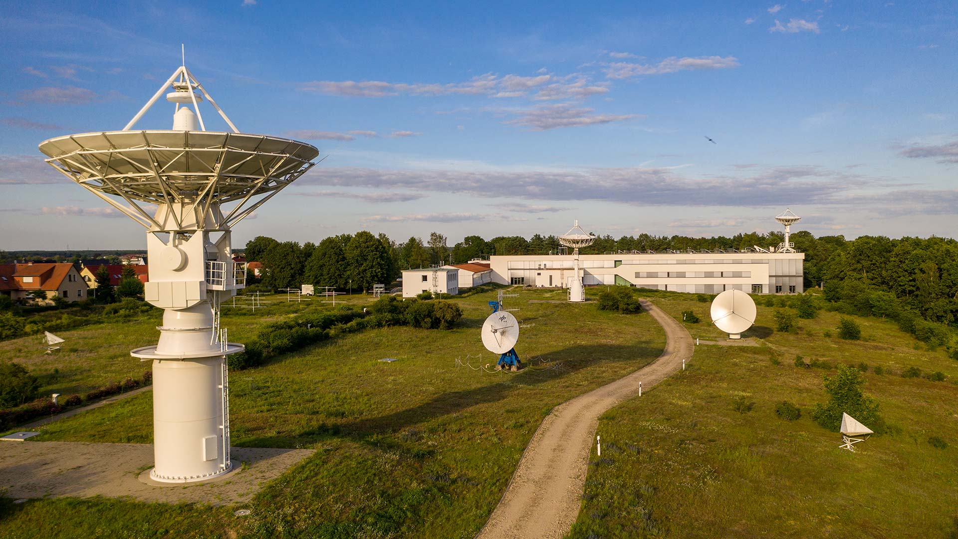
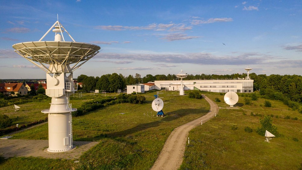
These days, such computer centres allow even small research groups and individuals to create new products or services using global Earth observation data. Until a few years ago, users had to download data onto their own personal computers and process it there. Today, the data often remains at the processing centre so that the algorithms are uploaded to the data instead. Companies such as Google and Amazon have discovered the potential of this service. They offer access to European Copernicus data and the necessary computing power from a single source – free of charge for research purposes in some cases, provided that they expect to benefit from the work somehow in future. The EOC today is part of this extremely dynamic Earth observation North of the Arctic Circle in the Northwest Territories of Canada, DLR's Earth Observation Center operates an antenna for receiving satellite data. The ground station in Inuvik is just 2500 kilometres from the North Pole. Following the fall of the Berlin Wall, Neustrelitz became a DLR site. Here, data from national and international remote sensing missions are received and information is generated in real time for applica tions such as maritime security.
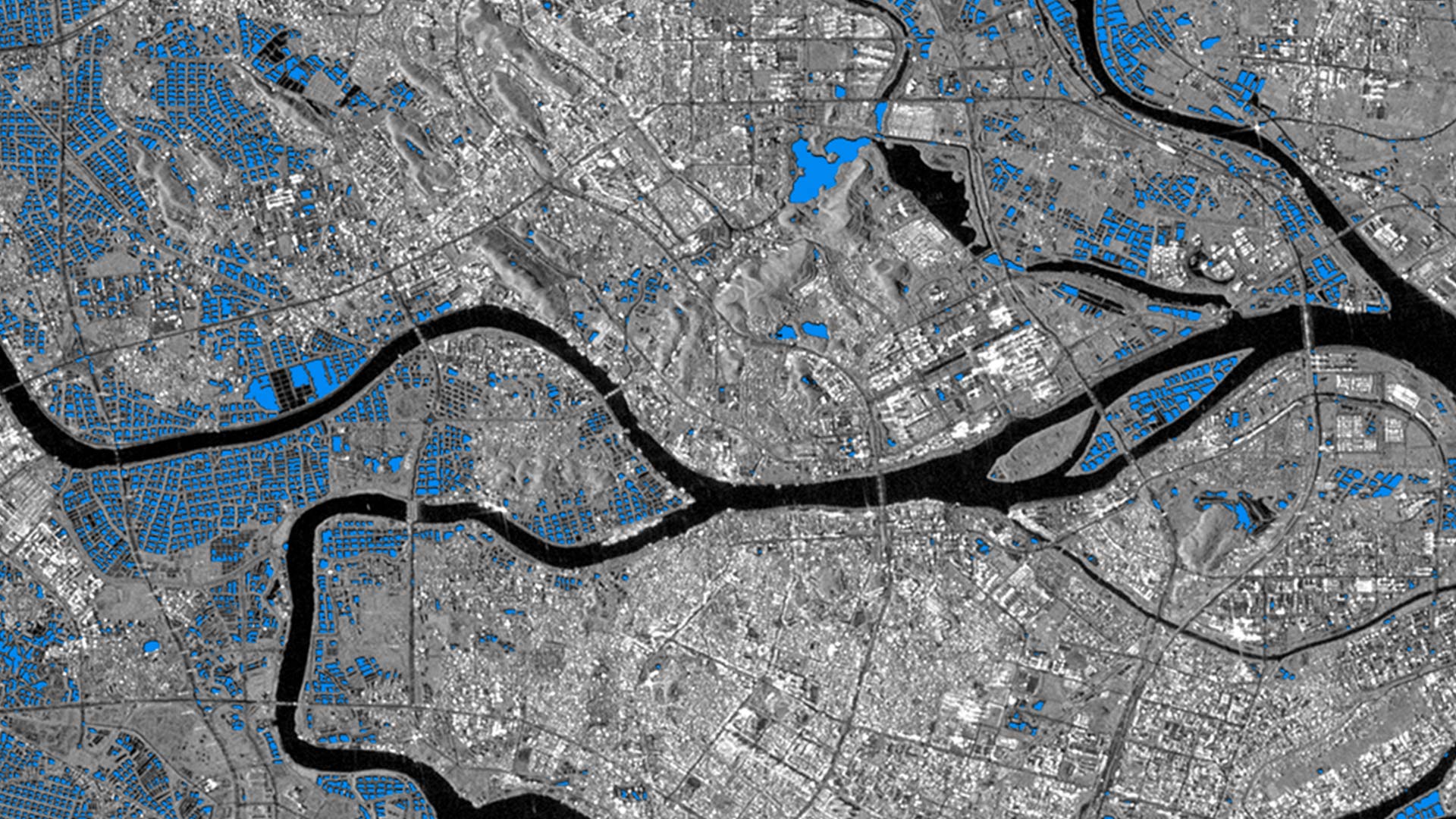
The DLR receiving station GARS O'Higgins in Antarctica can only be supplied by ship or aircraft. However, its location close to the South Pole on the Antarctic O'Higgins Peninsula is so well-suited for satellite communication that work is carried out there all year round. In a metropolis such as Cairo, it is often difficult to provide precise data on population density. Using the World Settlement Footprint in combination with data produced by the TanDEM-X mission, DFD experts estimate building heights worldwide. This information makes it possible to more accurately determine the distribution of the population. DFD developed an algorithm which detects typical aquaculture tanks in radar images. This makes it possible to estimate the growth and production volume of aquacultures worldwide. Aquaculture is often located in sensitive coastal and mangrove regions. This image shows the Pearl River. environment, which the institution and its predecessors have helped to shape for over 40 years. Parts of ESA’s ground segment were designed by its teams, for example. The EOC is still responsible for receiving, processing and managing satellite data on behalf of ESA and has been able to assert its position in an increasingly commercialised market. It is currently working with the Leibniz Supercomputing Centre of the Bavarian Academy of Sciences and Humanities to develop a promising alternative to the commercial providers for processing satellite data in the Cloud. This cooperation intends to maintain the user’s sovereignty when accessing and processing such data.
The EOC and its predecessor institutions have grown up alongside ESA and its space programme. However, the EOC has also developed par ticular strengths through its participation in Germany's own space programmes and radar missions. These included the world’s first radar system operating in the X-band, SIR C/X-SAR, which was launched in 1994, and the first Synthetic Aperture Radar (SAR) interferometer, which made its debut in 2000 on board the SRTM remote sensing mission. This sensor made it possible to create terrain models for Earth’s surface for the first time. The TerraSAR-X satellite, which carries a radar sensor with various modes of operation, was then launched in 2007. Its twin satellite, TanDEM-X, followed three years later.

The two satellites fly in close formation, enabling simultaneous imaging of the Earth’s surface in a process known as bistatic interferometry. No other space-faring nation had previously dared to have two satellites orbit each other in a helical path, separated by as little as a few hundred metre. The objec tive was to produce the first uniform, high-resolution global terrain model. The TanDEM-X mission demonstrated DLR’s unique selling point better than ever before: its systems capability for satellite control, instru ment development and data processing and analysis, all from a single organisation. In all of these national and ESA missions in which the EOC participated, it was able to develop the processing algorithms that took data from initial sensors all the way through to end-users. Ger many became a world leader in radar remote sensing. The amount of data produced by these missions also eclipsed everything that came before them and on the basis of this experience, the EOC is now well equipped to process the far larger quantities of data produced within the European Copernicus programme.
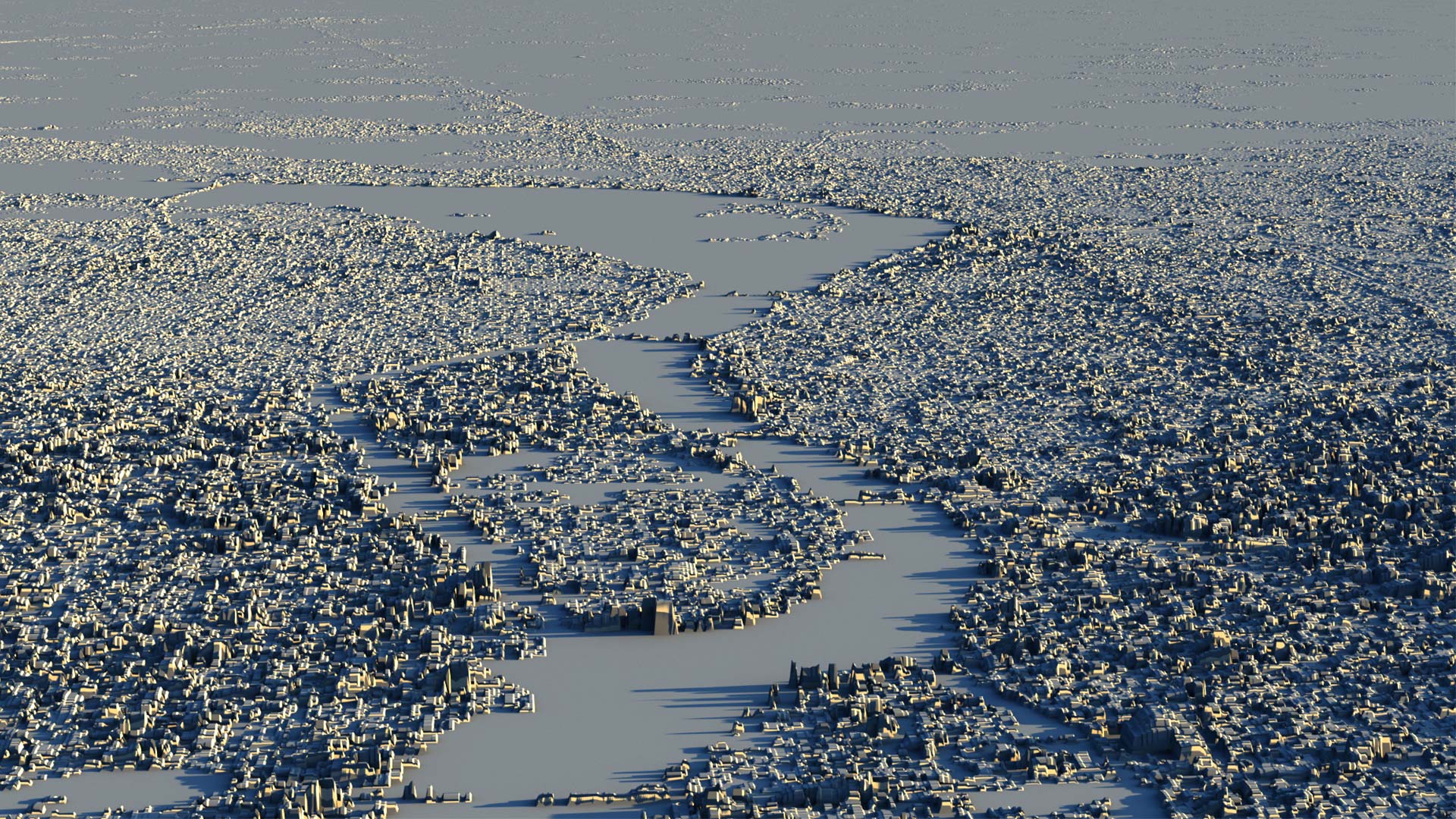
In order to efficiently analyse this wealth of ‘Big Data’, the EOC set up the ‘Artificial intelligence for Earth observation’ research area. Geoscientific research at the EOC has also been boosted by the large quantities of data. As one by-product of the TanDEM-X mission, for instance, the most accurate settlement map of the world ever was produced. Today, this map is being further developed using Sentinel data and supplemented with further elevation information from TanDEM-X. Using techniques from the fields of Big Data and artificial intelligence, and with help from social media, scientists at the EOC can even determine the type of individual buildings in a settlement. This allows them to determine how the population is distributed with far greater precision. This information is important for mapping at-risk areas, a process conducted by the EOC’s Center for Satellite-Based Crisis Information (ZKI). Atmospheric research also benefits, as it can more accurately estimate the number of people exposed to various degrees of atmospheric health risks.
Earth observation has become an integral part of people’s every day lives. Forty years ago, no one could have dreamt of the sheer volume and diversity of data that would be accessible today or the extent of the corresponding algorithms and processing capacities. The possibilities today afforded by the internet, exten sive fleets of satellites and everyday mobile applications were simply unimaginable.
The Earth Observation Center
The Earth Observation Center (EOC) is a DLR institute association comprising the Remote Sensing Technology Institute (IMF) and the German Remote Sensing Data Center (DFD). The DFD emerged from the Applied Data Technology Department, which was founded in 1980. The IMF was founded in 2000 following a comprehensive restructuring of DLR’s Earth observation department. Since then, the two institutes, which have sites in Oberpfaffenhofen, Neustrelitz, Berlin and Bremen, have worked together as a network, initially as the Applied Remote Sensing Cluster and, since 2010, as the Earth Observation Center. Today the EOC is a leading international centre of excellence for satellite-based Earth observation.