Tectonic stress on Mars – the landscape of Ascuris Planum
July 9, 2015
Tectonic stress on Mars – the landscape of Ascuris Planum
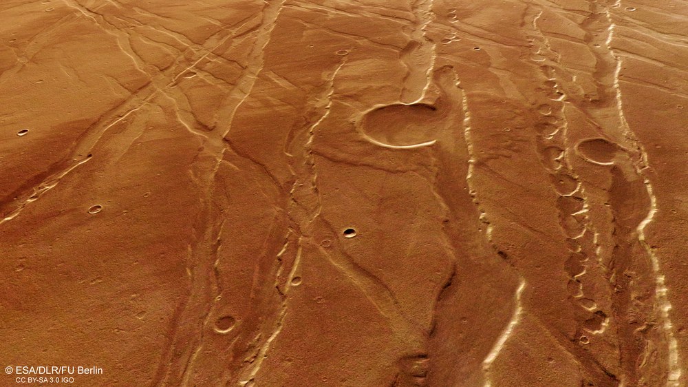
Perspective view of Ascuris Planum
Once the digital terrain models have been computed, the images acquired by the DLR High Resolution Stereo Camera (HRSC) on board Mars Express also allow the production of perspective views of the landscape. Besides parallel grabens and the odd example running crosswise to the primary alignment, this image also shows an older impact crater – on the right of the image – a subsidence crater chain.
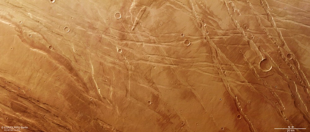
The Ascuris Planum region, situated northeast of the enormous volcanic region of Tharsis, is a striking example of a horst and graben landscape. The rectilinear or slightly curved faults, which are the result of extensional tectonics, are particularly noticeable here.
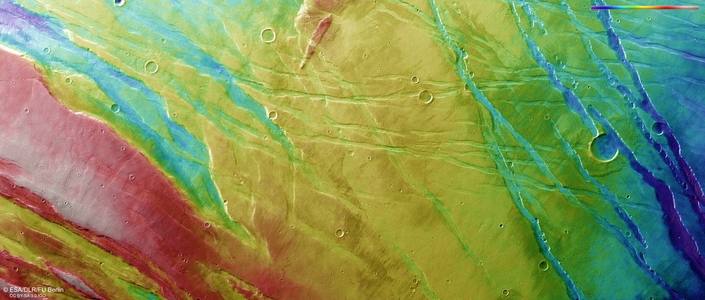
This digital terrain model of Ascuris Planum, computed using stereo image data acquired the HRSC camera, shows clear differences in elevation that extend to several hundred metres. These areas portray the grabens and the horsts on either side that tower above the surrounding landscape.
Geology is a fairly young science when compared with physics, mathematics or astronomy. Emerging from the quest for natural resources and ores, it developed into an independent field of research only in the last few centuries. In Europe, the focus of this work was in the low mountain ranges at the heart of the continent and the Alps, which is why what today is predominantly an English-language terminology adopted a large number of German technical terms to describe geological arrangements. A particularly striking example of this practice is the linguistic monstrosity 'horst and graben structures'. Numerous striking examples of these tectonic phenomena are found on Mars.
The Ascuris Planum area shown in these images is a particularly vivid case of a horst and graben landscape. The images were acquired by the High Resolution Stereo Camera (HRSC), operated by the German Aerospace Center (Deutsches Zentrum für Luft- und Raumfahrt;) on board ESA's Mars Express spacecraft. Ascuris Planum is located in the northeastern area of the enormous volcanic region of Tharsis, where a large number of similar geological structures exist. The Tharsis region extends across several thousand kilometres in each direction and exhibits an approximately five-kilometre elevation in the shape of a shield that emerged over several billion years. These processes created immense expansion stresses that transformed broad swathes of the region into horst and graben landscapes.
How do horst and graben structures emerge?
Expansion in a rigid and brittle rocky crust, precipitated, for instance, by an elevation in the substratum, generates stresses in the surface immediately above. Indeed, the crust will break open if the expansion stresses rise beyond what would be a 'tolerable' threshold for the rock, producing a fault zone. Any further expansion in the crust will cause large areas of rock located along the strain fault to slide several hundred metres – or even more than one kilometre – downward. Over millions of years, this phenomenon will produce a tectonic graben. The remaining blocks that flank these structures then tower above the landscape to form the matching horsts.
The Ascuris Planum landscape possesses a large number of geological features. The volcanic phenomena are particularly interesting alongside the complex tectonic structures. Volcanic activity has been a major factor across the entire Tharsis region; Alba Mons, located to the west in the immediate vicinity of Ascuris Planum, is one of the largest volcanoes on Mars. Numerous smaller shield volcanoes are found in this area – among them is Labeatis Mons (see image 4).
The faults, running in lines ranging from straight to moderately curved and that are responsible for the horst and graben landscape, are particularly eye-catching features here. Ascuris Planum is a section of the Martian crust that, over an extremely long period in the planet's history, must have been exposed to immense tectonic stress. Mostly parallel trenches scar the ground from the northeast to the southwest, although some do run crosswise to this principal alignment. This phenomenon is indicative of a change in the 'stress regime' – the name used by geologists to describe crustal tension. The borders of the grabens appear fresher and less eroded in the left-hand sections of the images (numbers 2, 3 and 5). A few solidified lava streams are visible on the highest points, which are best seen in the colour-coded topographical image map (image 5). Lava streams of this kind may have leaked along the fault lines in a manner not dissimilar to what is currently observed in some areas of the Hawaiian Islands.
Subsidence crater chains – signs of lava streams or water
The right-hand sections of the images (numbers 2, 3 and 5) show a number of parallel grabens, as well as one impact crater whose walls exhibit an opening. This means that the crater is older than the tectonic faults. Observations of this kind allow scientists – to a certain degree at least – to draw conclusions on how the geological processes unfolded over time. A series of isolated, circular depressions stretching along the fault lines and carved into the brittle and steep-walled grabens is another conspicuous feature. Here, geologists speak of subsidence crater chains. They are particularly commonplace along the flanks of flat shield volcanoes and may reveal the course of lava channels that once extended beneath the surface. The rocky roofs of the lava channels began to collapse as the streams became increasingly exhausted over time, producing this striking pattern. Phenomena of this kind are also found in a number of regions on Earth – for instance, Hawaii.
However, there are alternative explanations – entirely unrelated to volcanic activity – for these subsidence crater chains. Their assumption is that the crust expanded, producing these depressions into which rocky material eventually slipped. Groundwater may also have been a significant contributor to these structures; on Earth, these sequences of 'pits' in an otherwise intact landscape are seen predominantly in limestone hills, where they are known as sinkholes. The word describes circular depressions found, for instance, in the karstic landscapes of southeastern Europe or the Swabian Alps. They form when carbon dioxide from the air bonds with water to produce carbonic acid, which then, mixed with the surface water, corrodes the limestone to produce cave-like structures in the substrata as the leachate trickles down through the soil. Over time, the roofs over these caves gradually weaken to the point that they collapse. Although Mars does not have any limestone, there are certainly water-soluble deposits in many places – for instance in the form of sulphates – that occur most frequently in areas where water was once found.
Image processing
The images were acquired by the High Resolution Stereo Camera (HRSC), operated by the German Aerospace Center (Deutsches Zentrum für Luft- und Raumfahrt;) on board ESA’s Mars Express spacecraft, at 281 degrees east and 39 degrees north on 10 November 2014 during Mars Express orbit number 13,785. The image resolution is approximately 18 metres per pixel. The colour plan view (image 2) was acquired using the HRSC nadir channel, which is directed vertically downwards onto the surface of Mars, combined with the colour channels of the HRSC; the oblique perspective view (image 1) was computed from data acquired by the HRSC stereo channels. The anaglyph image (3), which conveys a three-dimensional impression of the landscape when viewed through red-blue or red-green spectacles, was computed based on data acquired by the nadir channel and one stereo channel. The colour-coded plan view (image 5) draws on a digital terrain model of the region indicating the landscape topography.
The HRSC experiment
The High Resolution Stereo Camera (HRSC) was developed at DLR and built in collaboration with industrial partners (EADS Astrium, Lewicki Microelectronic GmbH and Jena-Optronik GmbH). The science team, which is headed by Principal Investigator (PI) Ralf Jaumann, consists of 52 co-investigators from 34 institutions in 11 countries. The camera is operated by the DLR Institute of Planetary Research in Berlin-Adlershof.