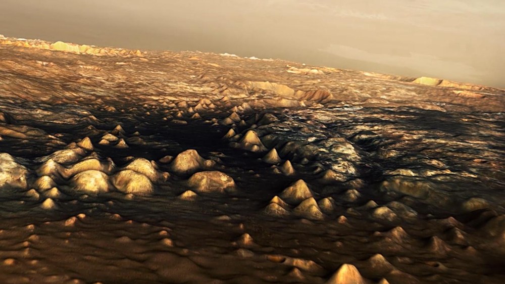
The difficult route followed by Mark Watney through the Martian highlands
The route that Mark Watney had to take to have a chance of being rescued is over 3000 kilometres long – he had to abandon his Mars station in Chryse Planitia and go through Mawrth Vallis (right of centre) in the Martian highlands to finally arrive at an obstacle-filled path into Schiaparelli Crater where the Ares-4 rocket had been ‘parked’ and where rescue might be possible. From highly accurate digital terrain models of the Arabia Terra region, DLR scientists have computed realistic perspective images of the regions encountered by Watney. The transition zone between the Martian lowlands and highlands is characterised by erosion and weathering processes that have left a harsh, rugged landscape. Mawrth Vallis is one of the potential choices for the landing module of the ESA ExoMars mission.
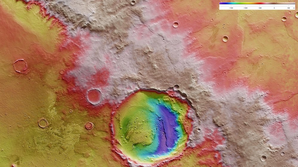
The last hurdle for Mark Watney - the edge of Schiaparelli crater
Schiaparelli crater has a 460 kilometre diameter and is located in the eastern Terra Meridiani region of the equator of Mars. This topographical map of the northwest rim of Schiaparelli reveals an approximately 25-kilometre crater in the raised crater rim; North is to the right in the image. The terrain is steep in places and therefore, dangerous for ‘The Martian’ Mark Watney and his fragile vehicle so, based on topographical data, he had to find the least steep route possible. He found this west (above) of the crater in the form of a sort of natural ramp, which formed as a result of a landslide in the crater rim, possibly during the impact that produced the small crater. On this ramp, he drove nearly 1000 metres down Schiaparelli - and was able to tackle the last 100 kilometers to the Ares 4 rocket. The crater was named after the Italian astronomer Giovanni Schiaparelli (1835-1910), who created the first good map of Mars between 1877 and 1879.
"In your face, Neil Armstrong!" – as he says these words, NASA astronaut Mark Watney senses for the first time that he might have only a very small chance of getting out of his predicament alive. Watney is 'The Martian' in the film of the same name (release date in Germany: 8 October) who, in a not too distant future, finds himself stranded on the Red Planet. The topographical and geographical maps play an essential role in allowing him to navigate the months-long trek to the Ares 4 spacecraft located in Schiaparelli Crater. Scientists from the German Aerospace Center (Deutsches Zentrum für Luft- und Raumfahrt; DLR) – who specialise in producing highly accurate topographical maps of Mars – reconstructed Watney's route using stereo image data acquired by the High Resolution Stereo Camera (HRSC) on board ESA's Mars Express spacecraft. They then compiled this data into a 3D film that shows the spectacular landscape that the protagonist would see 'in the future'.
https://vimeo.com/141517160
https://vimeo.com/141517160
Your consent to the storage of data ('cookies') is required for the playback of this video on Vimeo.com. You can view and change your current data storage settings at any time under privacy.
In the scene mentioned above, Watney has just managed to make contact with Ground Control back on Earth using a radio device taken from the Sojourner rover deployed on the Red Planet by the Pathfinder spacecraft in 1997. He was in possession of highly precise geographic coordinates that enabled him to locate the shoebox-sized rover. Maps of this kind are the foundation of all scientific work relating to Mars. For almost 12 years, the To the Institute's website has been using image data acquired by HRSC to produce digital terrain models of the surface of Mars. The Berlin-based DLR Institute is a world leader in the field of planetary surveying and mapping.
Elaborate calculations for the future on Mars
The story of 'The Martian' begins on a lowland plain extending across the planet's northern tropic, before moving several hundred kilometres away to the southwestern corner of Chryse Planitia, through a narrow outflow channel and out into the southeastern highlands in the Arabia Terra region of Mars. There, trapped in a desperate race against time and rapidly dwindling resources, Watney endeavours to reach the Ares 4 rocket that NASA had 'parked' in Schiaparelli Crater and to use it to leave Mars. DLR scientists recently presented a broad swathe of this terrain – roughly two-and-a-half million square kilometres of precisely mapped landscape that covers the areas described. This data was released as part of a project to map the entire surface of Mars.
DLR used this dataset to produce an overflight sequence for 'The Martian' using 7300 stereo images. The average computing time per image was approximately half an hour due to the detailed terrain and immense size of the region. Therefore, a total of five months of computing time went into producing the video. However, by spreading the workload across several computers, the schedule was significantly shortened, taking only two and a half months to complete the five minute
https://youtu.be/5sXW0gsJoZU
https://youtu.be/5sXW0gsJoZU
Your consent to the storage of data ('cookies') is required for the playback of this video on Youtube.com. You can view and change your current data storage settings at any time under privacy.
No other Mars dataset reveals the large-scale reality so well
Ralf Jaumann from the DLR Institute of Planetary Research, Principal Investigator for HRSC, believes that producing the overflight video was not just a gimmick for a science fiction film: "Mars generates immense fascination, and our curiosity continues to grow! Many people are interested in our research, and young people in particular want to know what it is really like up there, and how realistic the idea that one day people will leave their footprints on the surface of Mars truly is. The data acquired by HRSC shows Mars with a clarity and detail unmatched by any other experiment. Only images acquired directly on the surface, for instance by rovers like Curiosity, are even closer to reality, but they can only show a small part of the planet. Thanks to this animation, we have even noticed a few new details that we had not seen in a larger spatial context. That is why we made the film – it helps everyone see what it would be like for Watney to travel through these areas… the clouds were the only creative touches we added, because, fortunately, they do not appear in the HRSC data."
'The Martian' selects the logical topographical route
The original screenplay draws extensively on knowledge acquired from actual scientific missions to Mars to describe the protagonist's journey. NASA picked Chryse Planitia as a safe landing site for the Viking 1 spacecraft as far back as 1976, while Mars Pathfinder touched down at a location chosen for its proximity to the mouths of Ares Vallis and Tiu Valles. While the best route to the safety of Schiaparelli Crater and the Ares 4 spacecraft may have been punishingly arduous, it follows the perfectly logical path through Mawrth Vallis. The hydrous clay minerals found in this valley have made it a focus of current research into Mars. There are frequent sandstorms on the Red Planet, and in 'The Martian', they are portrayed very realistically in terms of their propagation very realistic, but not with regard to wind speeds.

