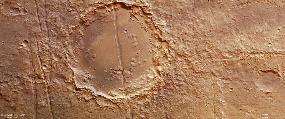
Memnonia Fossae is located to the west of the extensive Tharsis bulge in the Martian highlands. Heavily eroded, ancient impact structures such as this unnamed, 52-kilometre wide crater are typical of the region. As a result of expansion stresses in the Martian crust, numerous tectonic fractures running in an east-west direction have formed here – a one-and-a-half-kilometre wide graben stretches across the middle of the crater, together with other faults in the adjacent Martian highlands.
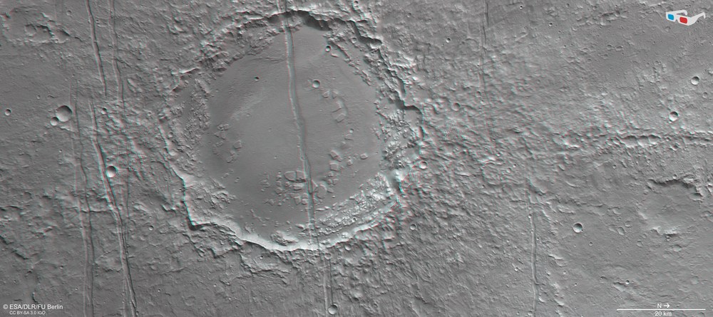
Anaglyph image of a tectonic fault zone in Memnonia Fossae
Anaglyph images can be created from the nadir channel of the HRSC camera system operated by DLR on board the ESA Mars Express spacecraft, which is directed vertically onto the surface of Mars, and the oblique view from one of the four stereo channels. When viewed through red-blue/cyan or red-green glasses, they allow realistic, three-dimensional views of the landscape.
This spatial view enables the grabens, which all run from east to west (north is to the right for technical reasons), and their environment to be artificially highlighted. The remnants of a number of terraces in the heavily eroded rim of the unnamed, 52-kilometre-wide crater are also visible as a result. Close to the right-hand edge of the image is a conspicuous group of three circular craters in a row – these are presumably secondary craters. These occur when the material ejected following the asteroid impact that gave rise to the primary crater is deposited in its surroundings immediately afterwards. Large pieces of ejecta travel a short distance, one behind the other, and then land radially to the crater rim, forming characteristic crater chains.
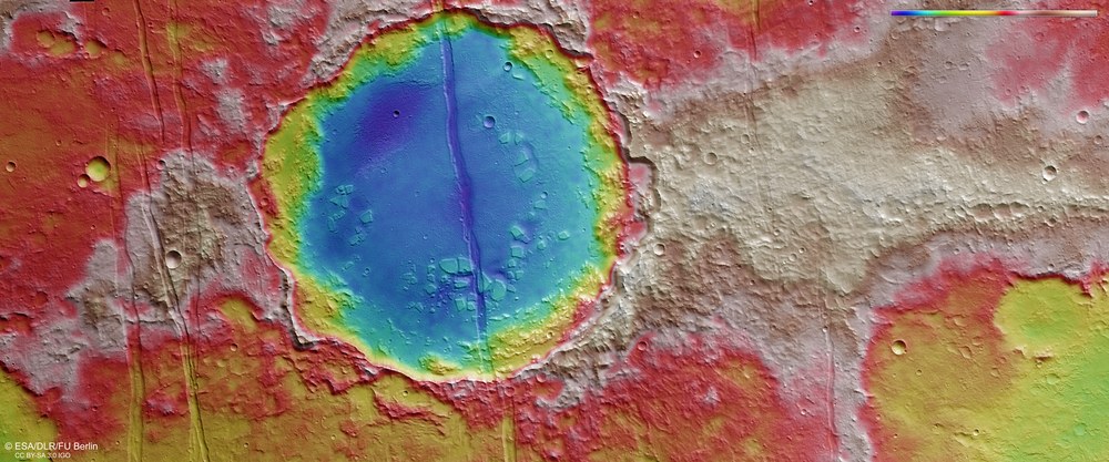
Colour-coded representation of the topography in Memnonia Fossae
Digital terrain models of the Martian surface with a resolution of down to 10 metres per pixel can be derived from data acquired by the HRSC nadir channel, which is directed vertically onto the surface, and the oblique views of the stereo channels. In this colour-coded image, the absolute elevations above a reference level, the areoid (derived from Ares, the Greek word for Mars), are depicted.
Using the colour scale in the upper right of the image, it becomes clear that the interior of the 52-kilometre wide crater in the centre of the image is around 1400 to 1700 metres deeper than the heavily eroded crater rim in the surrounding Martian highlands. The dimensions of the tectonic expansion can be derived from the 200- to 400-metre-deep, straight grabens. Geologists can use measurements of the subsidence of blocks of terrain in such structures to calculate the level of tectonic expansion stress in the region.
The images presented here, acquired by the High Resolution Stereo Camera (HRSC) operated by the German Aerospace Center (Deutsches Zentrum für Luft- und Raumfahrt; DLR) on board the European Space Agency (ESA) Mars Express spacecraft, show part of the Memnonia Fossae region on Mars. This chain of faults is located to the west of the Tharsis volcanic region and north of Sirenum Fossae – another large system of rifts and faults similar to Memnonia Fossae. These features are all the result of tectonic stresses in the Martian crust and extend over 1600 kilometres in an east-west direction. Their origin is attributed to the bulging of the Tharsis volcanic region. They have been named the 'Rifts of Memnonia' after a temple complex in the ancient Egyptian city of Thebes.
The Tharsis region on Mars has been uplifted like a bowl the size of Europe that bulges four to five kilometres upwards. Some of the largest volcanoes in the Solar System can be found here. These include Olympus Mons (22 kilometres high) and the three Tharsis volcanoes of Ascraeus Mons (15 kilometres), Pavonis Mons (8 kilometres) and Arsia Mons (11 kilometres). The exact origins of this bulging mechanism are not yet understood. However, it is very likely that large quantities of magma fed from the Martian mantle over billions of years have exerted pressure on the crust from below. Low-viscosity lava then flowed across the region from the volcanic cones and fissures and added layer upon layer of volcanic rock over large areas.
Martian crust under stress
The great weight of these additional layers of dense, iron-rich volcanic rock on the surface caused immense pressure. At the same time, the magma bubbles rising upwards from the Martian mantle were generating pressure from underneath. The Martian crust was therefore exposed to massive expansion stresses in the Tharsis region. This is evident in numerous tectonic rifts, faults and cracks in the bulging Tharsis shield and in the peripheral zones of this region (see also the image publication on Phoenicis Lacus dated 12 November 2010). The majority of these fracture zones extend outwards from the Tharsis region in a star shape and cut through the ancient southern Martian highlands.
This type of expansion stress has given rise to a landscape pattern typical of tectonically stressed regions, known in geological terms as a 'horst and graben structure'. Because of the pressure on the crust, huge blocks of terrain between two fault lines running in parallel collapsed hundreds or even thousands of metres downwards and created the tectonic 'graben', bordered on each side by the 'horsts' that remained standing.
More about volcanism on Mars:
Video Volcanism on Mars
Volcanism on Mars
Your consent to the storage of data ('cookies') is required for the playback of this video on Youtube.com. You can view and change your current data storage settings at any time under privacy.
Volcanism on Mars
Video Volcanism on Mars
Credit:
DLR
One very prominent graben is visible in the HRSC images, in an ancient impact crater with an already heavily eroded rim. It has a diameter of 52 kilometres and lies around 70 kilometres northeast of Dejnev Crater. This still unnamed crater is intersected by a graben 1.5 kilometres wide. Additional grabens can be seen to the north and south of the crater that appear to be split in some places and continue with a lateral offset.
Volcanism and wind erosion characterise the landscape today
Also prominent are a number of striking mesas that project several hundred metres above the level crater floor. The larger ones are up to 2.5 kilometres across. Their arrangement is somewhat reminiscent of many other 'chaotic terrains' on Mars – regions characterised by intense erosion. However, this small chaotic region, which appears to be the result of the crater being refilled with lava that presumably came from the deep rift, stabilised and hence protected the mesas from further erosion.
The many wind alleys created by wind erosion – referred to as yardangs – that can be found on the flat floor between the mesas and around the graben (especially in the western part of the crater floor) indicate that a less erosion-resistant material once filled the crater. This might be material that the wind carried in – such as sand or dust – or sediments that were transported and deposited here by water.
More about 'yardangs':
Video on the weather and climate on Mars
The weather and climate on Mars
Your consent to the storage of data ('cookies') is required for the playback of this video on Youtube.com. You can view and change your current data storage settings at any time under privacy.
The weather and climate on Mars
Video on the weather and climate on Mars
Credit:
DLR
Image processing
The High Resolution Stereo Camera (HRSC) acquired these images during Mars Express Orbit 14,689 on 1 August 2015. The region lies at 22 degrees south and 197 degrees east. The image resolution is about 14 metres per pixel. The colour plan view (image 1) was acquired using the nadir channel of the HRSC, which is directed vertically down onto the surface of Mars; the perspective oblique view (image 2) was computed using data acquired by the HRSC stereo channels. The anaglyph image (image 3), which creates a three-dimensional impression of the landscape when viewed with red/blue or red/green glasses, was derived from the nadir channel and one stereo channel. The colour-coded aerial view (image 5) is based on a digital terrain model of the region, from which the topography of the landscape can be derived.
The HRSC experiment
The High Resolution Stereo Camera (HRSC) was developed at DLR and built in collaboration with industrial partners (EADS Astrium, Lewicki Microelectronic GmbH and Jena-Optronik GmbH). The science team, which is headed by Principal Investigator (PI) Ralf Jaumann, consists of 52 co-investigators from 34 institutions in 11 countries. The camera is operated by the DLR Institute of Planetary Research in Berlin-Adlershof.