Cutting-edge technology for humanitarian aid workers – DLR is developing service tools for SOS Children's Villages International
October 14, 2016
Cutting-edge technology for humanitarian aid workers – DLR is developing service tools for SOS Children's Villages International
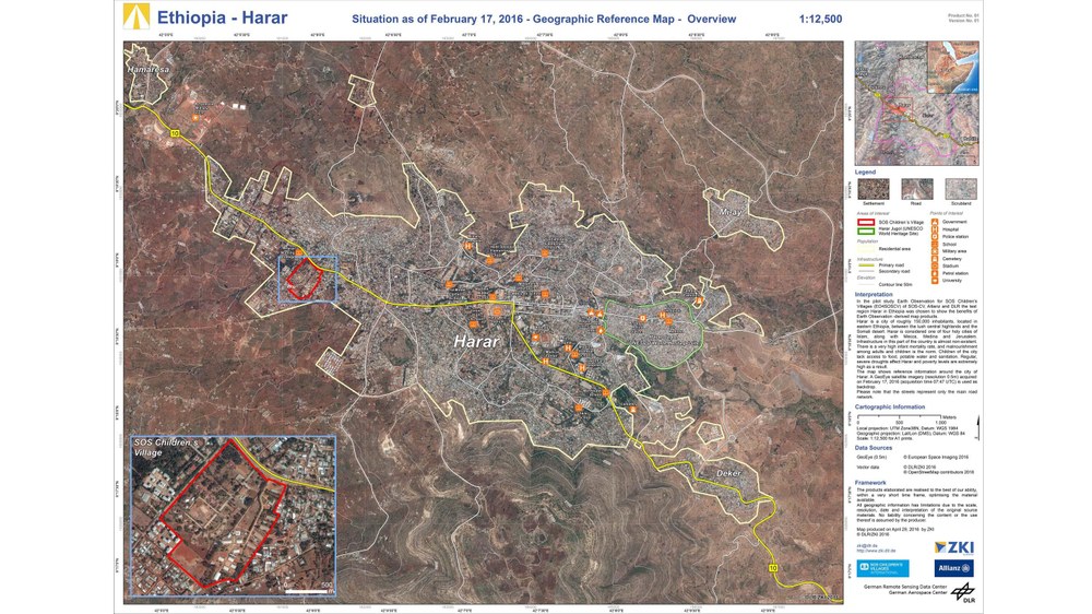
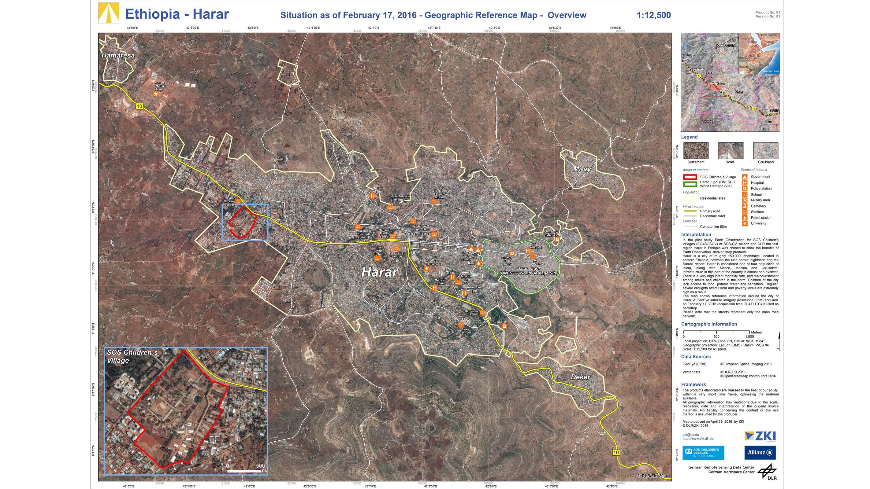
Geographical reference map of Harar in Ethiopia
With the aid of these environmental maps, the employees of SOS-Kinderdorf International can better assess the overall situation of their villages. In the event of an emergency, te maps provide additional information, such as flooded areas.
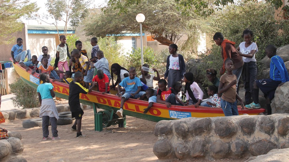
SOS Children's Villages International is responsible for over 1.5 million children and their families worldwide. In the pilot area in Western and Central Africa, there are 47 Children's Villages alone. In addition, there are youth centers, kindergartens, schools, social centres and medical facilities. Children in need get an SOS mother, siblings, a safe home in the SOS Children's Villages. In the protective framework of the village community, the boys and girls regain the courage to go confidently into the future. The SOS Children's Villages ensure the well-being of the children entrusted to them until they enter the workplace and, if necessary, even longer. At present, more than 78,000 children and teenagers live in the 560 children's homes and 659 SOS youth care programmes.
Image: 2/3, Credit:
Jude Fuhnwi / SOS Children's Villages International.
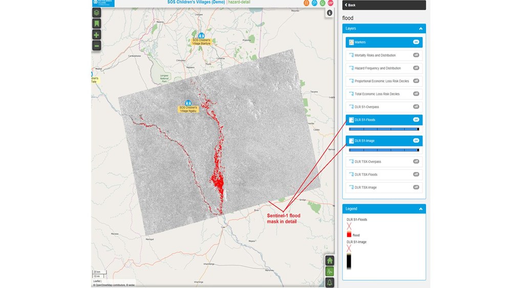
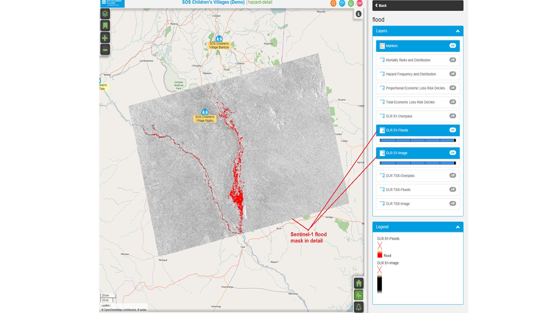
Satellite-based information on flooded areas nearby an SOS Children's Village
The ZKI incorporates the satellite data processed by them into a newly implemented emergency management system at SOS Children's Villages International. Thus, all employees have fast access to the data.
More than 1.5 million children and their families in over 130 countries around the world are currently receiving support from the humanitarian aid organisation SOS Children's Villages International. The Centre for Satellite Based Crisis Information (ZKI) at the German Aerospace Center (Deutsches Zentrum für Luft- und Raumfahrt; DLR) site in Oberpfaffenhofen is supporting the organisation by establishing emergency and disaster management concepts in order to provide effective assistance in the event of natural disasters, such as floods, earthquakes or forest fires. Using innovative technical solutions from the field of Earth observation, it should be possible to implement an early warning system. In addition, the ZKI is able to offer emergency mapping of affected facilities and support the NGO to further develop communication and work processes. Allianz SE is supporting the project as part of its global partnership with SOS Children's Villages International and is also offering its expertise so that the system can be optimised.
Early warning system for forest fires and floods
"In contrast to the authorities and civil protection agencies,such as the THW (Bundesanstalt Technisches Hilfswerk), humanitarian aid organisations often have limited access to the latest technologies," said Konstanze Lechner, Project Manager at the The German Remote Sensing Data Center (DFD), describing the situation. "But even Earth observation data products, such as that produced by the ZKI, is of vital importance for decision-making in the event of disasters. Many NGOs are active in crisis regions and areas that are often affected by natural disasters, and so depend on such emergency information to improve their disaster management. The ZKI is thus supporting SOS Children's Villages International in the further development of their emergency and disaster protection concepts by offering satellite-based crisis information.” During a six-month long project phase, from October 2016 to March 2017, ZKI staff members will, among other things, develop a satellite-based early warning system for forest fires and floods for SOS Children's Villages International. To achieve this, they will use data acquired by European weather satellites to detect fires, and data from the European Copernicus satellites will be used to detect floods. West Africa was selected as a pilot region for this project phase. SOS Children's Villages International run more than 297 facilities and projects in this region.
Emergency mapping for neighbourhood assistance
The ZKI has a wealth of experience in satellite-based emergency mapping. In the event of acute crisis situations, SOS Children's Villages International can call on the ZKI and request a satellite analysis for its facilities around the world. The focus is not only placed on the affected village, but also on the population in the surrounding area. "In most cases, SOS Children's Villages remain largely undamaged by earthquake and storm disasters because their construction is very robust. It is, therefore, more important for us to know how the situation is developing in the neighbouring areas – that is, where we care for families and run other social projects," said Andreas Papp, International Director for Global Emergency Response at SOS Children's Villages International. "After severe natural disasters our facilities are, more often than not, the only buildings left standing. That is why people come to us. In order to be able to help them effectively and support other relief forces, it is very important that we have access to an up-to-date situation map. This enable us to, for example, better plan and coordinate the needs of the children from the region, as well as the required quantity of emergency supplies."
New technology for humanitarian tasks
During severe natural disasters, a large part of the infrastructure, such as telecommunication networks and the power supply, is often damaged or even destroyed. To ensure that workers at the SOS facilities in those regions receive all the necessary information and can exchange it with external members, other forms of communication must be used. New technologies can also be, for example, used to ensure a reliable and fail-safe energy supply within the SOS Children's Villages. DLR is also able to offer technological support in these cases.
The current project will last six months, and the early disaster warning system and emergency mapping will, among other things, be integrated into the recently implemented emergency management system at SOS Children's Villages International. All necessary aspects required for optimal visualisation and information processing will be developed with other service providers. "Once the project concludes in March 2017, the ZKI will remain on hand as a consultant as well as to provide further technical developments in disaster management to SOS Children's Villages International," Lechner explained when talking about project completion.
