Sentinel-5P - a quantum leap in atmospheric observation
December 1, 2017
Sentinel-5P - a quantum leap in atmospheric observation
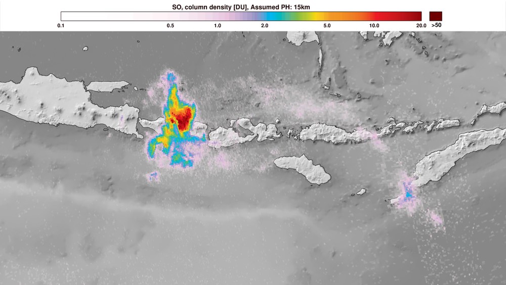
Sulphur dioxide map: volcanic eruption on Bali
On 27 November 2017 the Copernicus Sentinel-5P satellite captured the ash and gas clouds spewed into the air during the eruption of the Gunung Agung volcano on Bali in Indonesia. The map shows that the Sentinel-5P mission also measures aerosols as well as trace gases in the atmosphere.
Copyright: contains modified Copernicus Sentinel data (2017) processed by DLR/ESA.
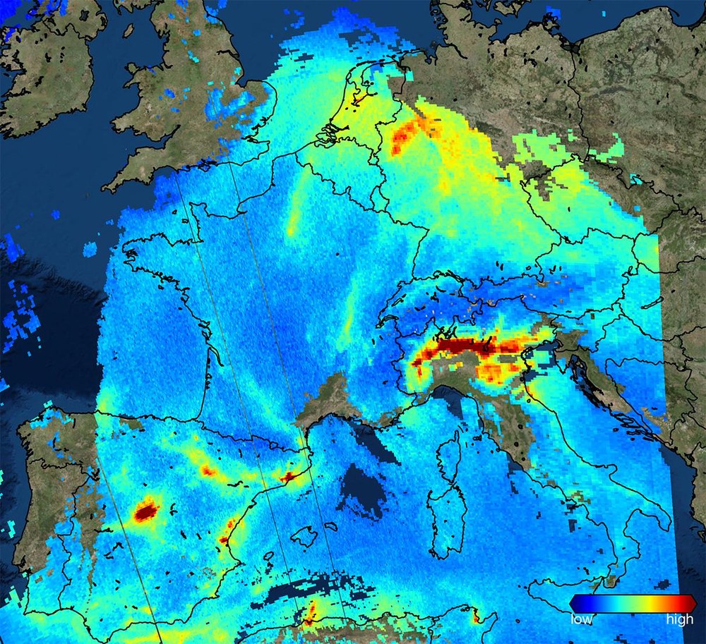
This image, created using data acquired by Sentinel-5P, shows the nitrogen dioxide pollution over Europe on 22 November 2017, indicating very high levels above the Po Valley in northern Italy and over western Germany. Fossil fuel combustion in the industrial sector and exhaust gases from road traffic are the main causes of nitrogen dioxide pollution. The image covers large parts of Europe, showing the swath width of 2600 kilometres acquired by the TROPOspheric Monitoring Instrument (TROPOMI). The image contains modified Copernicus Sentinel data (2017), processed by KNMI/ESA.
Image: 2/4, Credit:
Contains modified Copernicus Sentinel data (2017) processed by DLR/ESA.
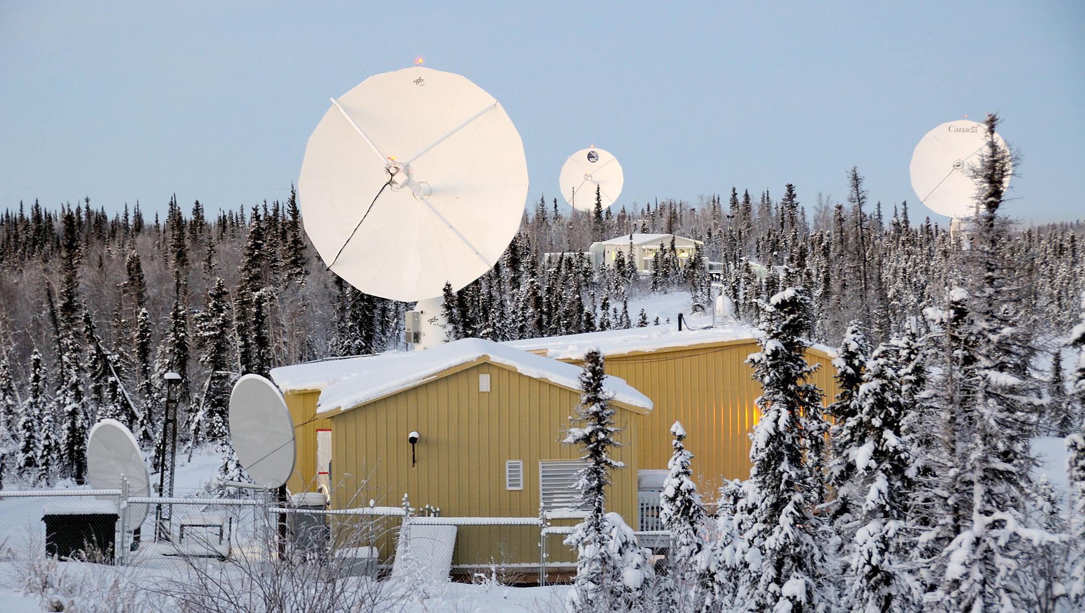
DLR operates its own receiving facility at the International Station Facility (ISF) of the Canada Center for Mapping and Earth Observation (CCMEO) in Inuvik, Canada. Sentinel-5P's scientific data is received here, as well as at the KSAT ground station in the Norwegian Svalbard.
The first satellite images from the Sentinel-5 precursor are available
Data service will provide real-time information on air quality, ozone and climatic factors
Sentinel-5P offers a global coverage and a resolution that is up to 100 times higher than previously
Focus: Earth observation, digitalisation, big data
The first satellite images from the Sentinel-5 precursor were presented at the Earth Observation Center (EOC) of the German Aerospace Center (Deutsches Zentrum für Luft- und Raumfahrt; DLR) in Oberpfaffenhofen on 1 December 2017. They give a taste of the new data service. Soon, timely information on air quality, ozone and climatic factors will be available – with global coverage and a resolution up to 100 times higher than previously. Sentinel-5P is the most recent fleet member of the European Copernicus Earth observation programme; the atmospheric data and map products gained from this are freely accessible.
"Sentinel-5P is opening up completely new possibilities for observing the atmosphere at an unprecedented resolution. With Sentinel-5P, we can, in particular, expand our knowledge of the air quality over large cities and how it evolves, and also observe any changes that result from political measures, for example," says Stefan Dech, Director of the DLR German Remote Sensing Data Center.
Air quality and health care
The Sentinel-5P satellite is equipped with a highly sensitive spectrometer and records important trace gases, aerosols and cloud information. The TROPOMI instrument (TROPOspheric Monitoring Instrument) measures the content of sulphur dioxide, ozone, formaldehyde, nitrogen dioxide, carbon monoxide, methane and aerosols, as well as parameters regarding the height, distribution and albedo of clouds. Using this highly accurate data, environmental and climate researchers can improve simulation models and make more accurate forecasts.
But the new data products are not only valuable for scientific applications, but also for companies and citizens. Smartphone apps and Internet services with information on air quality or how weather affects biological factors will benefit from this highly accurate data. Various types of air pollution have a negative effect on risk groups, such as people who suffer from asthma, patients with respiratory diseases or cardiovascular problems, allergy sufferers, the elderly and small children. More detailed daily information on the local ozone levels can thus provide valuable indications for everyday life. The World Health Organization (WHO) now considers air pollution one of the world’s greatest environmental risks.
Initial data
Thanks to its high spectral resolution and wide wavelength range Sentinel-5P is capable of delivering more than 100 measured points per unit area. In addition, the spectrometer has a spatial resolution of up to 3.5 kilometres by 7.5 kilometres. This allows it to document air pollution and its sources very accurately. For instance, coal-fired power plants, refineries and volcanic eruptions are identified through increases in sulphur-dioxide values. For example, one of the first Sentinel-5P images showed the recent volcanic eruption on Bali, among other things. Analysis of aerosol and trace gas measurements provides an exact picture of how the ash and gas cloud has expanded over the Indonesian island since the volcano Gunung Agung erupted on 25 November.
Daily traffic on the ground, water or in the air also leaves traces behind in the atmosphere in the form of nitrogen dioxide, ozone and other pollutants. Using Sentinel-5P, even smaller sources within a city can now be recorded, which reveal the traffic and energy patterns of settlements. A current Sentinel-5P analysis shows high levels of nitrogen dioxide above western Germany and northern Italy, primarily caused by car exhausts and the burning of fossil fuels in industry.
How maps are produced
Sentinel-5P does not provide ready-made maps of trace gases, but initially just a spectrum of measured data. The raw data must therefore be made usable through complex mathematical-physical procedures: The various respective parameters are extracted from the spectrum, combined as required, and run through special algorithms – only then is the data product produced, such as a representation of the ozone values over a specific area. The algorithms for data analysis and the software for generating some of the atmospheric information were developed at the The Remote Sensing Technology Institute (IMF).
"The enormous data rate due to the high resolution of TROPOMI and the high demands regarding the accuracy of atmospheric information presented huge challenges for our algorithm developers, even though we were able to draw on 20 years of experience in this field. The most cutting-edge procedures, such as machine learning, have now allowed us to process the data stream of 20 million real-time measurements per day into high-quality information products," says Richard Bamler, Director of the DLR Remote Sensing Technology Institute. Within the future data service of Sentinel-5P, a total of 13 products supplying current information will be made available just three hours after the measurements are taken. The mission is designed for a lifetime of at least seven years – making continuous use of new global atmospheric data.
The The German Remote Sensing Data Center (DFD) (DFD) is responsible for receiving, processing and distributing the data. For this purpose, the DFD uses – among other things – its base stations in Inuvik in northern Canada, as well as the stations of technology partners, for example in Spitzbergen. The great challenge of this mission is the complex, ramified streams of data and information that are required to generate the information products. Satellite data and a wide range of supplementary data merge in Oberpfaffenhofen. Here, the data management and processing system designed by DFD ensures that the interwoven processing steps run smoothly and the information products are continuously delivered.
Long-term trove of data
In addition to their near real-time availability, the atmospheric data is also of inestimable value for long-term observations. Sentinel-5P guarantees continuous observation of specific trace gases. Thus, the data will also offer the opportunity to identify and understand the processes of change. Simply viewing the series of data stretching back decades makes clear why certain developments in Earth's ecosystem occur and how they can be influenced.
The DFD runs the German Satellite Data Archive in Oberpfaffenhofen and Neustrelitz and secures the growing trove of Sentinel-5P data there for future generations. The reprocessing of all mission data is also possible if new analysis techniques become available in the future. As a result, the unique insights of the satellite will be retained beyond the mission and can be supplemented through future Earth observation missions.
About the mission
The Sentinel-5P satellite was launched successfully on 13 October 2017. The Sentinel-5P mission was developed within the scope of the European Copernicus Earth observation programme under the aegis of the European Space Agency (ESA - European Space Agency) and the Netherlands Space Office, as was the scientific payload, the TROPOMI instrument. The satellite data is analysed by the Royal Netherlands Meteorological Institute (KNMI) and the German Aerospace Center (DLR). The mission is supported by the member states of ESA, the Netherlands Space Office and the European Union.

