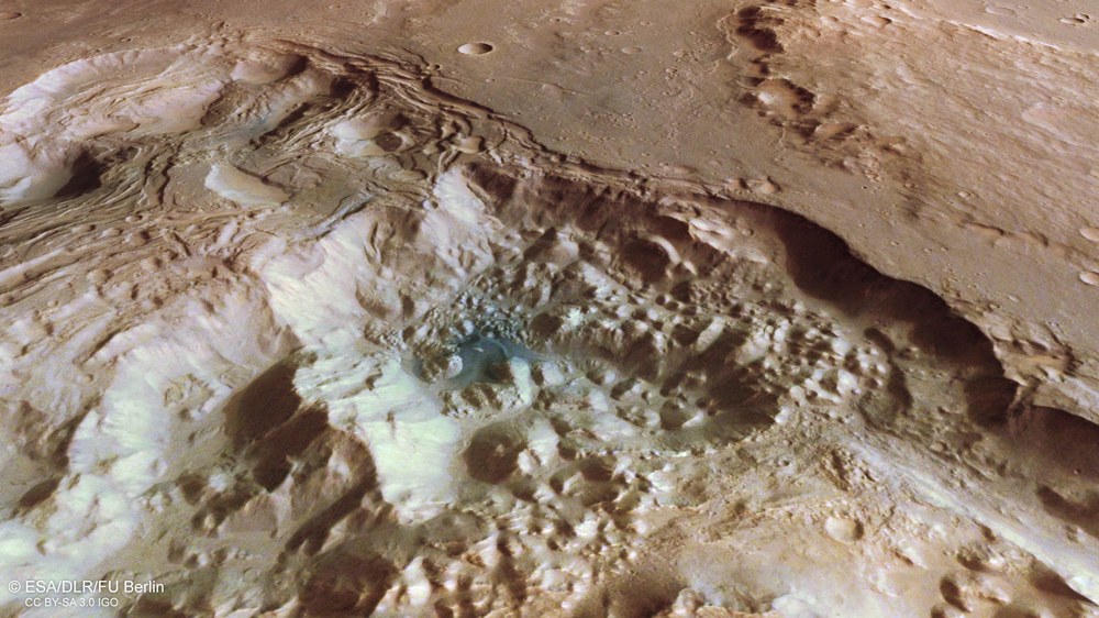
Pyrrhae Regio, south-east of Eos Chasma, a side valley of the Valles Marineris, is a typical three-to-four-billion-year-old highland plateau with numerous craters, some of which are already heavily eroded. In its northern part (right, in the image) an unusual landscape is noticeable. This is an area about 50 by 40 kilometres, consisting of interconnected depressions, terraced slopes on the sides, and in the far north seemingly ‘chaotic’ hills in a dense arrangement. A long time ago, this ‘chaotic terrain’, a term used by geologists researching Mars, was formed here after ice thawed under the surface of the highland plateau, flowed away and the resulting cavities collapsed. Just visible are heavily eroded valleys that flow into the depressions from the south, an indication that there has also been an outflow of water on the surface. The three old craters in the south, which are between 20 and 50 kilometres in diameter, are filled with sediment.
This oblique perspective view from northeast to southwest over part of Pyrrhae Regio is spectacular. As with other ‘chaotic terrain’ in the wider area east of the Valles Marineris, a landscape reveals itself in which numerous ‘chaotically’ distributed mesas can be seen in a depression. It was formed when water stored as ice under the plateau thawed and flowed northwards in high-energy flash floods. What remained was an area in which the highlands collapsed, and the edges slipped off in terraces, thereby massively changing the landscape. The topography, which is not visible from this perspective, is also impressive; from the highland plateau in the background to the lowest points of the chaotic area, the difference in altitude is more than 4000 metres.
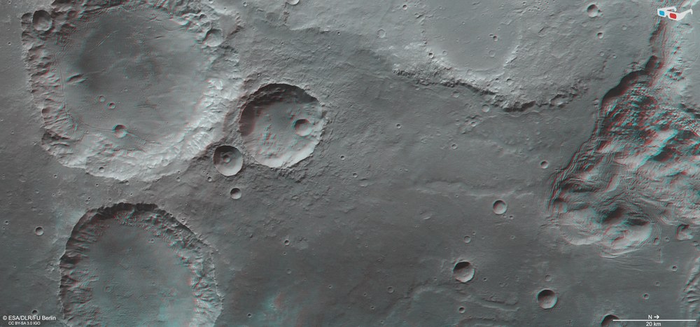
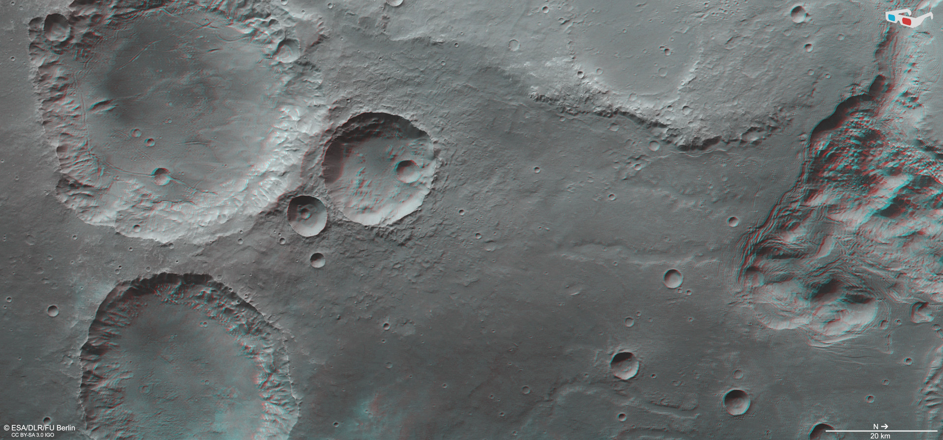
Anaglyph images can be generated using data acquired by the nadir channel of DLR’s High Resolution Stereo Camera (HRSC) on ESA’s Mars Express Orbiter and one of the four stereo channels with an oblique view. When using red-blue or red-green glasses, these images provide a three-dimensional view of the landscape. North is on the right of this image. Here the topography of the three large, prominent craters in the south of the scene (left in the image) is very clearly visible. The already heavily eroded crater rims show that the landscape is very old and that the craters were probably formed more than three billion years ago. But the view into the more than 4000-metre-deep depressions in the north, whose sides are bordered by terraces, is particularly spectacular. In them, water has left behind a wildly rugged landscape, referred to as ‘chaotic terrain’, which is typical of these regions on Mars.
These images, acquired by DLR's HRSC instrument, show a 'chaotic terrain' located in Pyrrhae Regio in the southern highlands of Mars.
Numerous flood events have left traces behind.
HRSC has been mapping the Red Planet at unprecedented resolution, in three dimensions and in colour since 2004 as part of ESA's Mars Express mission. Its data are an important resource for present and future Mars research.
Focus: Space, planetary research, Mars
These High Resolution Stereo Camera (HRSC) images show a fascinating landscape near the major canyon system of Valles Marineris on Mars. On a high plateau with numerous craters lies a geologically ‘disturbed’ aera, the technical term being ‘chaotic terrain’. Such terrain forms occur when underground ice reservoirs melt and large amounts of water are released from the subsurface. The heat necessary for such a process could have been emitted by nearby volcanoes or generated by asteroid impacts. After the water has drained away, the surface above the newly formed cavities collapses, and the overlying landscape falls in. What remains are numerous ‘chaotically’ scattered mesas.
HRSC was developed and is operated by the German Aerospace Center (Deutsches Zentrum für Luft- und Raumfahrt; DLR). HRSC has been mapping the Red Planet at unprecedented resolution, in three dimensions and in colour, since 2004 as part of ESA's Mars Express mission. Its data are an important resource for present and future research on Mars. The findings acquired during the course of the mission have significantly changed our understanding of the Red Planet’s geological development.
Catastrophic floods have left their mark
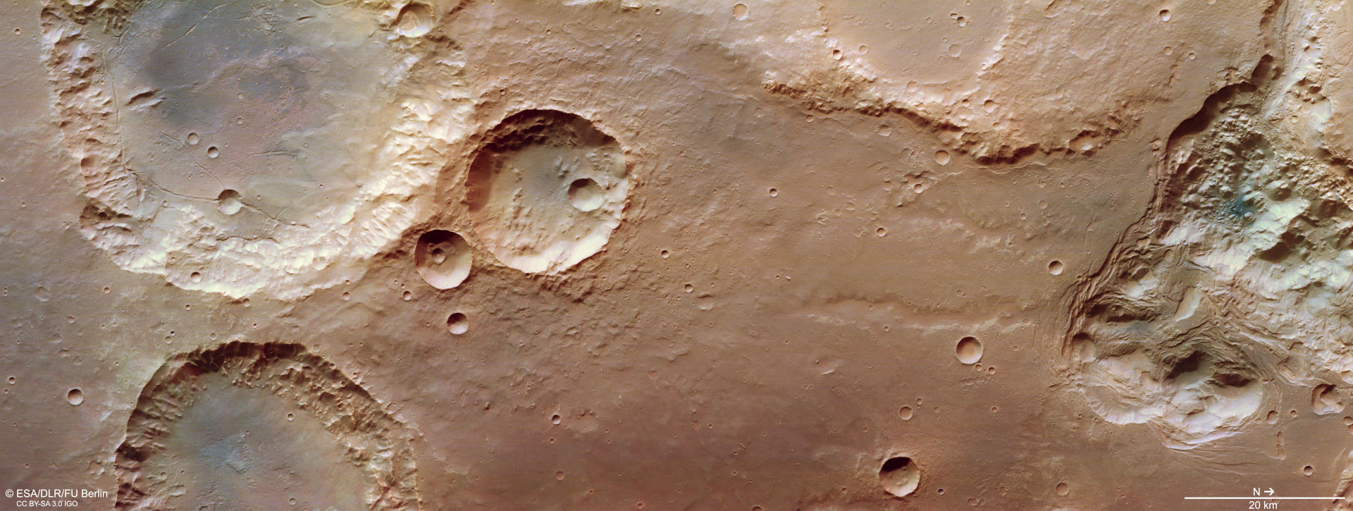
South of Eos Chasma, or the 'Gorge of Dawn' – an eastern branch of the major Valles Marineris valley system – lies Pyrrhae Regio. It is situated on an ancient highland plateau covered with craters. These HRSC images show an impressive chaotic landscape at their right-hand edge.
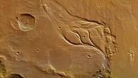
The overview map (Image 3) shows a larger part of the surrounding landscape. In the northeast (outside the marked rectangular HRSC image section) branching river channels, called the Osuga Valles, flow into this chaotic region. Scientific investigations of the collapse structures in Eos Chasma, in the southwest and Pyrrhae Regio, and the outflow channel system of the Osuga Valles, which lies between the two, revealed that at least two opposite outflow events occurred here. First, there was an outflow from Pyrrhae Regio in Eos Chasma, and later an outflow in the opposite direction.
After water and sediment flowed out of Pyrrhae Regio, rugged blocks remained in the depression where ice was once hidden in subsurface cavities and thus protected from sublimation (vaporisation under the low atmospheric pressure of Mars). Presumably, in addition to meltwater, groundwater leakage also occurred. The escaping groundwater then led to landslides and collapses at the outer edges of the small chaotic area. The concentric structures at the edges of the terrain bear striking witness to how the slopes slid down into the interior of the depression. The difference in altitude here is four thousand metres. The amount of material released and removed was therefore enormous.
Sapping valleys
On the southern side (left in Images 1, 4 and 5) two large and one small impact crater can be seen, the latter measuring approximately 20 kilometres in diameter. The largest crater shows some linear fracture structures on the crater floor. They were probably formed when lava, which escaped into the crater interior after the impact, cooled down rapidly and contracted. Between the crater and the chaos area two valleys can be seen. Both are two kilometres wide. These valleys, especially the upper one, show great similarity to sapping valleys. In this form of erosion, groundwater emerges directly at the edge of the terrain or slightly below it as if from a trickling spring. This erodes and hollows out the slope. As a result of material slipping along the top edge of the terrain, the erosion edge migrates further and further back as material is carried away by flowing water. This creates steep, U-shaped valley structures.
Some background on mythology
The region was named after Pyrrha, daughter of Pandora and Epimetheus. She was the wife of Deucalion, who in Greek mythology has the same role as Noah in the Old Testament. He was asked by his father Prometheus to build an ark to save himself and his wife from the great flood that Zeus had summoned to destroy humankind. Pyrrha and Deucalion were the only ones to survive the catastrophe. They re-created humanity by throwing rocks over their shoulders, from which human beings emerged.
These images were acquired by the High Resolution Stereo Camera (HRSC) on 3 August 2020 during Mars Express orbit 20,972. The resolution is approximately 16 metres per pixel. The centre of the images is located at approximately 322 degrees east and 16 degrees south. The perpendicular colour view was generated using data acquired by the nadir channel, the field of view which is aligned perpendicular to the surface of Mars, and the colour channels of HRSC. The oblique perspective view was computed using a Digital Terrain Model (DTM) and data acquired by the nadir and colour channels of HRSC. The anaglyph, which provides a three-dimensional view of the landscape when viewed using red-green or red-blue glasses, was derived from data acquired by the nadir channel and the stereo channels. The colour-coded topographic view is based on a DTM of the region, from which the topography of the landscape can be derived. The reference body for the HRSC DTM is a Mars equipotential surface (Areoid).
HRSC was developed and is operated by the German Aerospace Center (Deutsches Zentrum für Luft- und Raumfahrt; DLR). The systematic processing of the camera data was performed at the DLR Institute of Planetary Research in Berlin-Adlershof. Personnel in the Department of Planetary Sciences and Remote Sensing at Freie Universität Berlin used these data to create the image products shown here.
The HRSC experiment on Mars Express
The High Resolution Stereo Camera (HRSC) was developed by the German Aerospace Center (Deutsches Zentrum für Luft- und Raumfahrt; DLR) and built in collaboration with partners in industry (EADS Astrium, Lewicki Microelectronic GmbH and Jena-Optronik GmbH). The science team, which is headed by Principal Investigator (PI) Ralf Jaumann, consists of 52 co-investigators from 34 institutions in 11 countries. The camera is operated by the DLR Institute of Planetary Research in Berlin-Adlershof.


