February 2, 2022 | The first German hyperspectral satellite is ready to depart from Bremen
EnMAP will see our Earth in more than just colour
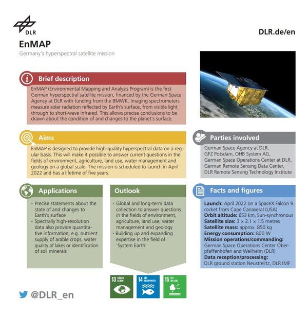
The German EnMAP environmental satellite
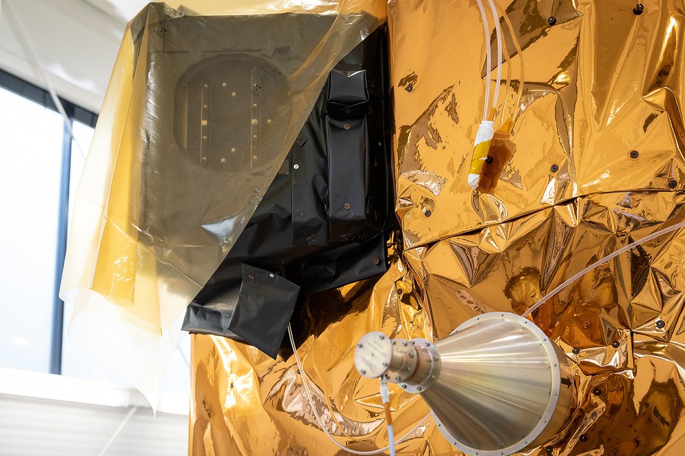
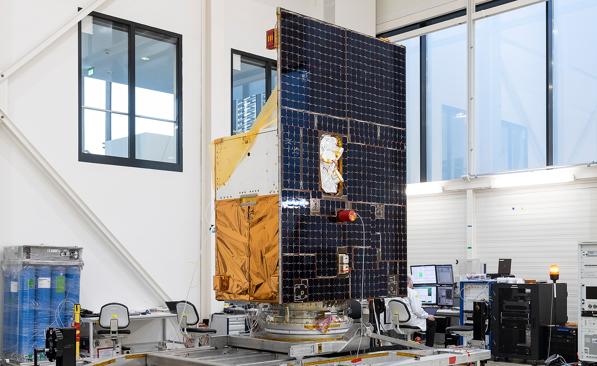
The German EnMAP environmental satellite in a cleanroom at OHB System AG in Bremen. The final tasks are being carried out here before the satellite is transported to NASA's spaceport in Florida at the end of February 2022.
EnMAP's hyperspectral instrument has more than 220 colour channels that can achieve a ground resolution of 30 metres from an altitude of 650 kilometres.
The German hyperspectral satellite EnMAP will observe Earth from an altitude of approximately 650 kilometres and provide important information in the fight against climate change and environmental destruction.
Its journey into space is drawing nearer – the German environmental satellite EnMAP is scheduled to launch from NASA's Kennedy Space Center in Florida at the beginning of April 2022. EnMAP is the first German hyperspectral satellite and will use novel technologies to collect high-precision data about Earth for at least five years.
The mission is being led by the German Space Agency at DLR on behalf of the Federal Ministry for Economic Affairs and Climate Action.
The satellite and its hyperspectral instrument have been developed and constructed by OHB System AG, while the ground segment is being developed and operated by DLR in Oberpfaffenhofen. The German Research Centre for Geosciences in Potsdam (GFZ) is the scientific lead for the mission.
The Environmental Mapping and Analysis Program (EnMAP) satellite, the first hyperspectral satellite developed and built in Germany, is still in a clean room in Bremen. The final tasks are being carried out and the spacecraft is on the 'home straight'. If everything goes according to plan, the new satellite will be transported to NASA's spaceport in Florida by an Ilyushin Il-76 transport aircraft at the end of February 2022. From there, EnMAP is expected to set off for its destination orbit in early April 2022 on board a SpaceX Falcon 9 launcher. The hyperspectral satellite will collect data on the state of our home planet for at least five years.
From an altitude of approximately 650 kilometres, EnMAP will keep an eye on and monitor Earth in 'more than just colour' with unique images from space. To do this, it analyses the solar radiation reflected from Earth's surface. Its high-resolution spectral images can play an important role in the fight against climate change and environmental degradation and provide valuable information for devising countermeasures. The mission is being led by the German Space Agency at the German Aerospace Center (Deutsches Zentrum für Luft- und Raumfahrt; DLR) in Bonn on behalf of the Federal Ministry for Economic Affairs and Climate Action (Bundesministerium für Wirtschaft und Klimaschutz; BMWK).
"Germany is a world leader in Earth observation – this has been proven once again today. Thanks to EnMAP's innovative hyperspectral sensor technology, Earth will be observed in unprecedented detail," explains Anna Christmann, a member of the Federal Parliament and Federal Government Coordinator of German Aerospace Policy. She adds: "With data from space, we can protect our planet. EnMAP will help us make global land use sustainable, highlight the consequences of climate change and counteract ongoing environmental degradation. The satellite is an excellent example of how cutting-edge space technology can be used for the benefit of humanity and the environment."
As a German environmental mission, EnMAP has its sights set primarily on climate change and its effects on all ecosystems - both on land and water. From an altitude of around 650 kilometres, EnMAP will keep a close eye on our Earth.
Trailer: Environmental satellite EnMAP is ready for use in space
Your consent to the storage of data ('cookies') is required for the playback of this video on Youtube.com. You can view and change your current data storage settings at any time under privacy.
Trailer: Environmental satellite EnMAP is ready for use in space
As a German environmental mission, EnMAP has its sights set primarily on climate change and its effects on all ecosystems - both on land and water. From an altitude of around 650 kilometres, EnMAP will keep a close eye on our Earth.
Earth is dynamic. Satellites are an important tool for monitoring and documenting climate change and other changes. Take precision farming, for example; EnMAP can help to precisely determine the nutrient and water supply of plants as well as soil properties. This can help to address the issue of global food security, but also answer questions concerning the sustainable extraction and storage of raw materials.
"EnMAP's spectrometers are based on Earth observation technologies that have been successfully developed and used in Germany for years. These allow us to see the Earth in a new perspective," emphasises Anke Kaysser-Pyzalla, Chair of the DLR Executive Board. "The data acquired by EnMAP will open up new possibilities for scientists. In particular, these include observing the global ecosystem, monitoring and searching for resources, and improving the response to humanitarian crises. The management of such demanding missions, the scientific handling of data, its processing and evaluation, as well as in mission control, demonstrate DLR's diverse and interdisciplinary capabilities as a national aerospace research centre."
Walther Pelzer, a Member of the DLR Executive Board and Head of the German Space Agency at DLR, emphasises: "EnMAP has technological, scientific and industrial policy objectives for us. It is our pioneer for hyperspectral remote sensing, a sensor technology that has so far only been used from aircraft. We are now applying this technology to an operational satellite mission for the first time. For example, we will be able to provide quantitative measurements of the composition of Earth's surface – in other words, the material composition, which can only be done with hyperspectral remote sensing. EnMAP also offers more than 220 colour channels that can achieve a resolution of 30 metres on the ground from an altitude of 650 kilometres. For comparison, a standard camera has three channels." NASA is also preparing a hyperspectral mission and is exchanging information with German experts. At the European level, this technology, developed and built in Germany, will be used on future Copernicus missions.
OHB System AG was commissioned to develop and construct the satellite and the hyperspectral instrument. "The satellite platform from Bremen and the highly complex EnMAP instrument, which was designed and manufactured at OHB's 'Optics & Science' Space Center in Oberpfaffenhofen, Bavaria, form the basis of a completely new type of global Earth observation mission. We have worked at the edge of what is technically feasible and created a powerful instrument with expertise, experience and passion. In the process, we have carried out pioneering work and expanded our expertise enormously. We will incorporate this into other satellite missions. EnMAP will provide a valuable contribution in the fight against climate change and for greater environmental protection as its data will provide clear recommendations for action to address the pressing issues of our time," adds Marco Fuchs, CEO of OHB SE.
EnMAP was developed as a scientific mission and therefore primarily provides data to scientists and developers from research and industry. Standard areas of application are forestry and agriculture, geology and soils, as well as water management and pollution monitoring. The areas of atmospheric and greenhouse gas research have also expressed great interest in the EnMAP data. The range of applications for the data is very broad. "The launch of this satellite marks a milestone in the history of the German Research Centre for Geosciences in Potsdam (Deutsche GeoForschungsZentrum; GFZ)," says the Director of the GFZ Geodesy Department, Harald Schuh. "Our colleagues have been working together with the international EnMAP Science Advisory Group on the mission's research programme for many years." The Potsdam team is also coordinating the extensive EnMAP-PI project for scientific utilisation, preparation and support. This is being carried out jointly with Humboldt-Universität zu Berlin, the University of Greifswald, the Alfred Wegener Institute, Helmholtz Centre for Polar and Marine Research in Bremerhaven and Ludwig-Maximilians-Universität München (LMU Munich).
How does EnMAP work?
Every material on Earth's surface reflects sunlight in a way that is characteristic of that material, referred to as its spectral signature. EnMAP can 'read' these signatures with the help of its observation instrument. To avoid confusing one signature with that of another substance, these signatures must be sampled with high precision. This is done with the help of multi-channel images (referred to as hyperspectral images). Using special evaluation processes, the materials and composition of different land surfaces, natural as well as urban, can then be identified and quantified. As an example, it can be used to identify not only which type of crop is grown on a field, but also how well it is supplied with nutrients. Minerals in soils can also be identified and quantified, as well as algae and suspended matter in bodies of water.
Media footage as well as animations and a mission video can be downloaded here:
EnMAP – the German environmental mission and its partners
The EnMAP environmental mission is managed by the German Space Agency at DLR in Bonn on behalf of the Federal Ministry for Economic Affairs and Climate Action (BMWK). OHB System AG was commissioned to develop and build the satellite and its hyperspectral instrument. The German Research Centre for Geosciences (Deutsche GeoForschungsZentrum; GFZ) in Potsdam is the scientific lead for the study.
Three DLR institutes and facilities have been commissioned to set up and operate the ground segment. The German Space Operations Center in Oberpfaffenhofen will conduct and monitor satellite operations, while the German Remote Sensing Data Center and the DLR Remote Sensing Technology Institute will archive, process and validate the received satellite data and make them accessible to users in the scientific community. Companies and public authorities will also be able to view the data and use them to prepare future services. The use of EnMAP hyperspectral data by universities and scientific institutions and the development of special applications will be supported by BMWK funding programmes.
