German EnMAP environmental satellite delivers first images
May 4, 2022 | Initial data demonstrate the performance of the hyperspectral instrument
German EnMAP environmental satellite delivers first images
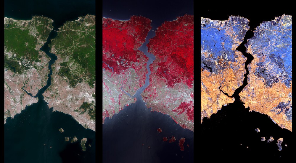
EnMAP – one image, a wealth of information
The German EnMAP environmental satellite has imaged a strip approximately 30 kilometres wide and 180 kilometres long over Istanbul, Turkey, with its hyperspectral instrument. These three sections are each approximately 30 kilometres by 54 kilometres and show the Bosporus, where the European continent meets the Asian continent. The left image shows a true-colour representation, which roughly corresponds to human colour perception, with this area being scanned by the VNIR camera with almost 50 individual fine channels. The middle image is a false colour image from the VNIR camera. In the near infrared, differences in vegetation become visible, which are related to the plant species and their condition, such as their biomass and chlorophyll content. The image on the right was taken with the SWIR camera in the short-wave infrared. Here, special features in the soil such as clays and in the rock, such as lime, can be identified and conclusions drawn about soil fertility.
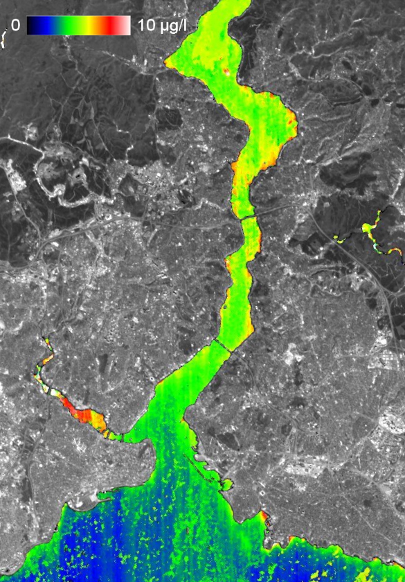
EnMAP has measured the chlorophyll density in the Bosporus with its hyperspectral instrument. The strait between Europe and Asia connects the Black Sea with the Sea of Marmara and is a busy sea lane. The chlorophyll concentration is very pronounced in the red areas and indicates strong algal growth.
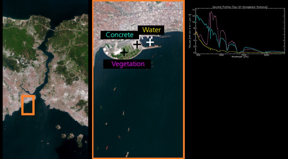
EnMAP records many pixels with its hyperspectral instrument. For each 2D pixel in the final image, there are many spectral profiles that give us important information about different materials, such as plants, concrete or water, and their state.
The German Environmental Mapping and Analysis Program (EnMAP) satellite has delivered its first images, one month after launch.
The mission is managed by the German Space Agency at DLR in Bonn on behalf of the German Federal Ministry for Economic Affairs and Climate Action (BMWK).
OHB System AG was contracted to develop and build the satellite and the hyperspectral instruments. The German Research Centre for Geosciences (GeoForschungsZentrum; GFZ) in Potsdam is the scientific lead for the mission.
The German Environmental Mapping and Analysis Program (EnMAP) satellite, which is managed by the German Space Agency at the German Aerospace Center (Deutsches Zentrum für Luft- und Raumfahrt; DLR) in Bonn on behalf of the Federal Ministry for Economic Affairs and Climate Action (BMWK), has spent roughly one month in space since its launch on 1 April 2022. It has now delivered its first high-resolution satellite images. Following the successful completion of the mission’s Launch and Early Orbit Phase, the individual subsystems of the highly complex hyperspectral instrument were put into operation piece by piece under the control of the German Space Operations Center (GSOC). EnMAP has now imaged a strip approximately 30 kilometres wide and 180 kilometres long over Istanbul on the Bosporus, Turkey, where Europe meets Asia and sent the data down to Earth via the DLR ground station in Neustrelitz.
"The first data from EnMAP have demonstrated what the German environmental satellite is capable of," says a delighted Sebastian Fischer, EnMAP Project Manager at the German Space Agency at DLR. The mission is still in its first phase, in which the hyperspectral instrument is being calibrated and precisely adjusted. "But these first images already give us a very good idea of what researchers around the world can expect. They show that EnMAP can make a major contribution to highlighting the consequences of climate change and counteracting the ongoing destruction of the environment."
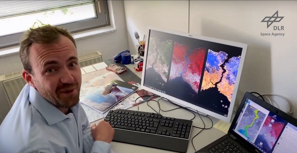
The hyperspectral satellite EnMAP has delivered its first Earth observation images. Project Manager Sebastian Fischer explains the images and the conclusions that can already be drawn from them.
The first images from the EnMAP environmental satellite
Your consent to the storage of data ('cookies') is required for the playback of this video on Youtube.com. You can view and change your current data storage settings at any time under privacy.
The first images from the EnMAP environmental satellite
The hyperspectral satellite EnMAP has delivered its first Earth observation images. Project Manager Sebastian Fischer explains the images and the conclusions that can already be drawn from them.
Credit:
Deutsche Raumfahrtagentur im DLR
The first data were received by the German Remote Sensing Data Center (DFD) and the DLR Remote Sensing Technology Institute, which also process and archive the images. The data that the satellite sends to Earth cannot be utilised directly by end users. Only when they are further processed – when they are calibrated, provided with position and attitude data and the influences of the atmosphere are corrected – can users draw quantitative and qualitative conclusions from the products. The calibration of these first images was carried out using data measured by the instrument in the laboratory as a reference. During the commissioning phase, which lasts six months, these calibrations will be optimised for the characteristics of the instrument in orbit and the data quality will be further improved.
First EnMAP images make the invisible visible to our eyes
But what can we actually see in the EnMAP images? Every material on Earth's surface reflects sunlight in a characteristic way, leaving behind a spectral signature. EnMAP can recognise, distinguish and image this 'colour fingerprint' with the help of its measuring instrument. Thus, the mission's motto is 'Our Earth in more than just colour', because each EnMAP image is divided into a great many small wavelength ranges – many more than our eyes can perceive. "The high quality of the data in all channels is clearly visible in typical spectra, such as for vegetation, and in low noise and disturbing image stripes in the extensive dynamic range, which is particularly evident in dark areas such as water. Based on this initial data, researchers at the DLR Earth Observation Center (EOC) were already able to derive preliminary results on the distribution of 'chlorophyll a' concentration at the water surface after atmospheric correction and by means of inverse modelling," adds Tobias Storch, Project Manager of the EnMAP ground segment at the EOC.
EnMAP – the German environmental mission and its partners
The EnMAP mission is being managed by the German Space Agency at the German Aerospace Center (Deutsches Zentrum für Luft- und Raumfahrt; DLR) in Bonn on behalf of the Federal Ministry for Economic Affairs and Climate Action (Bundesministerium für Wirtschaft und Klimaschutz; BMWK). OHB System AG was contracted to develop and build the satellite and the hyperspectral instruments. The German Research Centre for Geosciences (GeoForschungsZentrum; GFZ) in Potsdam is the science Principal Investigator for the mission.
Three DLR institutes and facilities have been commissioned for the construction and operation of the ground segment. The German Space Operations Center in Oberpfaffenhofen will conduct and monitor satellite operations, while the German Remote Sensing Data Center and the DLR Remote Sensing Technology Institute will archive, process and validate the received satellite data and make them available to the scientific community. Companies and public authorities will also test the data and use them to prepare future services. The use of EnMAP hyperspectral data by universities and scientific institutions and the development of special applications will be supported by BMWK funding programmes.

