June 7, 2023 | The Earth observation system is Europe's staunchest ally in environmental monitoring
25 years of Copernicus - a success story
Snow cover in the Western Alps reaches the lowest levels ever recorded in some areas in spring 2023
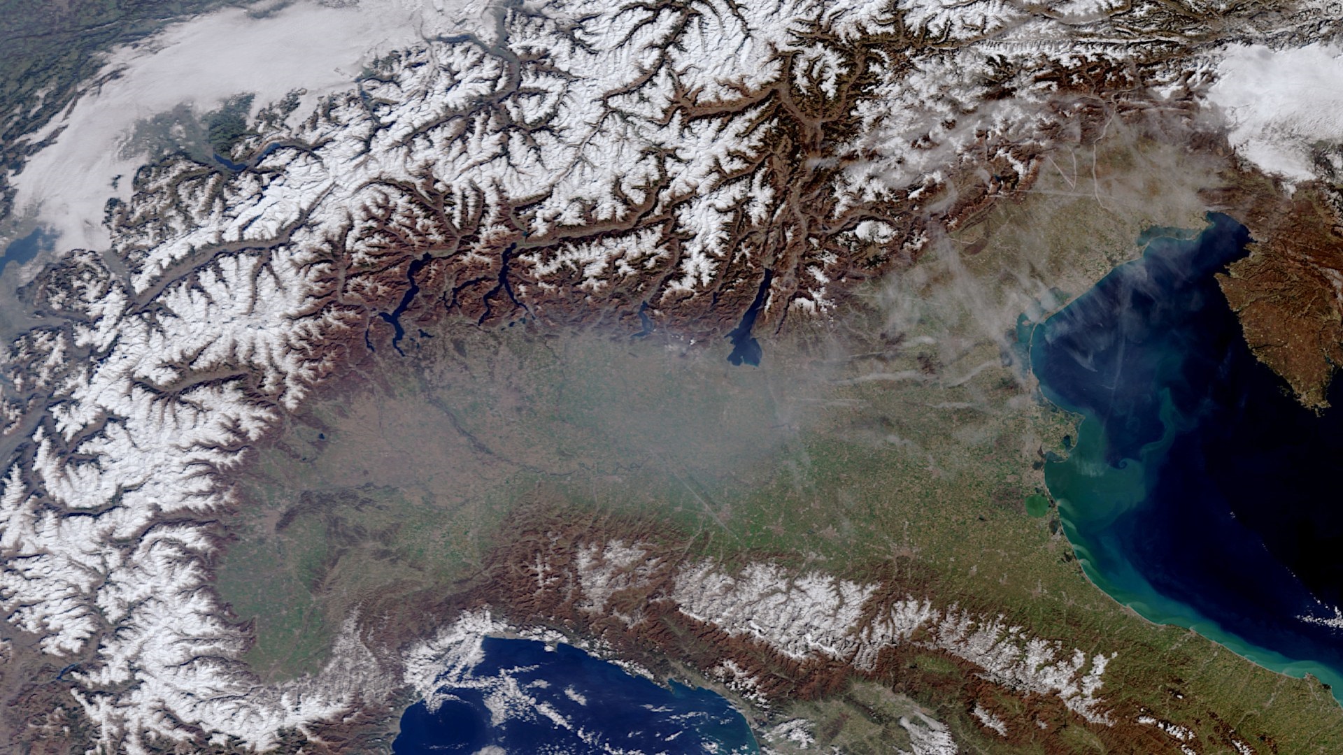
This image, acquired using one of the Copernicus Sentinel-3 satellites on 5 March 2023, shows the low level of snow cover in the Italian and Swiss regions of the Alps. The daily snowmelt equivalent for the winter of 2022/2023 in this area was consistently and significantly below the previous record value of 2021/2022 and the overall winter average calculated for the period from 1998 to the present.
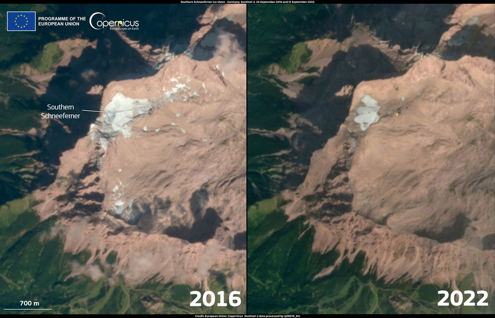
This Sentinel-2 image shows the decline in ice extent of the Southern Schneeferner glacier. The alpine glacier was severely affected by the extremely high temperatures in the summer of 2022. Due to the limited remaining ice mass, the Southern Schneeferner will stop flowing downhill and can thus no longer be called a glacier.
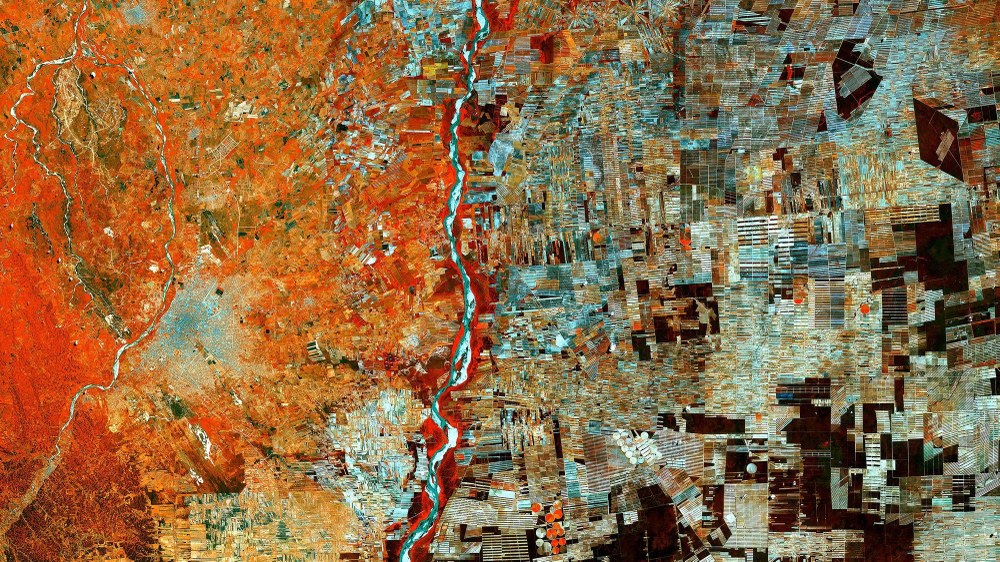
This Sentinel-2 image shows an area of Bolivia that was once part of the Amazon rainforest, but which has since been cleared for settlement programmes and agriculture. A large patchwork of agricultural fields can be seen to the east of the city of Santa Cruz (centre left). As recently as the 1960s, this was an area of dense Amazon rainforest. Since the 1980s, forests have been clear-cut on a large scale, partly to develop the area for agriculture.
Image: 5/5, Credit:
contains modified Copernicus Sentinel date (2017), processed by ESA, CC BY-SA 3.0 IGO
On 8 June 2023, the European Earth observation programme Copernicus celebrated its 25th birthday.
The information from the seven Sentinel satellites is the basis for research and monitoring of climate change, applications in modern agriculture and disaster response.
Earth observation data helps monitor adherence to treaties such as the Paris Agreement and supports the European Green Deal. The German Space Agency at DLR supports the programme on behalf of the German Federal Ministry for Digital and Transport at European level.
Focus: Space, Earth observation
What began in 1998 under the name 'Global Monitoring for Environment and Security' (GMES) is now Europe's largest and most successful Earth observation programme: on 8 June 2023, Copernicus will celebrate its 25th birthday. The information from the programme's current seven Sentinel satellites is the basis for researching and monitoring climate change, as well as for applications in modern agriculture and disaster control. The data also serve as the basis for important international environmental and climate protection agreements, for example, within the framework of the United Nations (UN) climate conferences and the UN Sustainable Development Goals.
A strong boost for the Paris Agreement and the European Green Deal
On 1 June 2023, the Copernicus Atmosphere Monitoring Service reported an unusually high number of forest fires in the global northern hemisphere this spring. Especially in Spain, Canada and Russia, the fires were particularly intense for the time of year and in some cases caused record carbon emissions. This was triggered by persistent drought and lack of precipitation in the affected regions. In 2022, the Copernicus Climate Change Service reported that summer temperatures in Europe were the highest since records began, at 1.4 degrees Celsius above the European average. Warming of the surrounding seas also reached a new high, while a record loss of ice mass of five cubic kilometres was recorded in the Alps. Overall, the European continent warmed twice as fast as the global average in recent decades.
These examples show the importance of Copernicus data and their analyses for monitoring and detecting climate and environmental changes. The resulting information and reports not only bring the issue to the public's attention but also influence political decision making, such as the agreements reached at the UN climate conferences. The data from Copernicus and other satellite missions are then also indispensable for monitoring and enforcing compliance with these agreements, such as the Paris Agreement.
Copernicus data also support the European Green Deal, in which the European Union commits to becoming climate neutral by 2050. The data also assist the planning and monitoring of the measures necessary to adapt to the impacts of climate change in Europe and of greening measures to preserve biodiversity in agriculture. These include, for example, the conservation of permanent grassland or the creation of water bodies, flowerbeds or forest edges. Copernicus also provides information on the condition of arable soils and crops, as well as their nutrient supply. This enables fertilisers to be used in a more targeted and economical manner, for example, which relieves the stress on soils and water bodies.
Emergency services provide assistance following earthquake in Turkey and major flooding in the Ahr Valley
In the event of natural disasters such as the earthquakes in Turkey and Syria in February 2023 or the major flooding in Germany in July 2021, in which parts of the states of Rhineland-Palatinate and North Rhine-Westphalia suffered greatly, the Copernicus Emergency Management Service (CEMS) is activated. The Service supports emergency response workers and regional authorities by supplying maps containing the latest situational awareness information. Satellites thus make an important contribution to the planning and coordinating of emergency and rescue measures in the affected areas, some of which may be otherwise isolated from the outside world. In addition, the Copernicus Early Warning services for floods (European Flood Awareness System; EFAS, Global Flood Awareness System; GLOFAS) and droughts (European Drought Observatory; EDO, Global Drought Observatory; GDO) are continuously being improved to enable the early detection and spatial delimitation of disaster risks. An early warning of a drought, for example, enables the timely provision of humanitarian aid.
From GMES to Copernicus
The history of the Copernicus Earth Observation programme began in 1998 with the signing of the Baveno Manifesto. The Manifesto emphasised the importance of environmental monitoring in addressing global challenges such as climate change, sustainable development and civil security. The resulting programme was initially called Global Monitoring for Environment and Security (GMES) and later renamed Copernicus. The name commemorates the astronomer and mathematician Nicolaus Copernicus, who first described the heliocentric model of the Solar System in 1543.
Copernicus is a joint programme of the European Union (EU) and the European Space Agency (ESA). Through the programme, the EU operates satellite-based information services for land surfaces (CLMS), oceans (CMEMS), atmosphere (CAMS), disaster and crisis management (CEMS), climate change (C3S) and civil security (CSS). These services are based on the data acquired using the Sentinels, a series of six satellites operated by the EU together with the European Organisation for the Exploitation of Meteorological Satellites (EUMETSAT). Copernicus also incorporates satellite data from third parties, such the German satellites TerraSAR-X and TanDEM-X. Data portals such as the Copernicus Data and Exploitation Platform – Germany (CODE-DE), ensure users easy access to Earth observation data.

