Mars Express mission – Lava channels on the southern flank of Ascraeus Mons
May 11, 2023
Mars Express mission – Lava channels on the southern flank of Ascraeus Mons
Collapsed voids on the south-west flank of Ascraeus Mons
Sinuous, downslope rilles with steep sides, flat bottoms and no raised rim occur frequently on the flanks of the large shield volcanoes on Mars. Starting from collapse structures, low-viscosity lava probably flowed continuously through them, eroding these narrow channels and troughs into a mechanically weak subsurface.
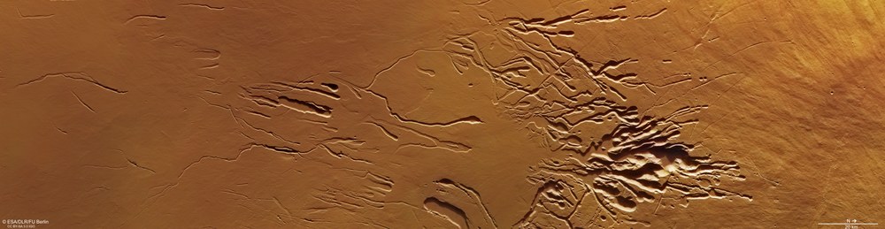
Ascraeus Mons is the northernmost and highest of the three volcanoes known as Tharsis Montes. With a diameter of approximately 480 kilometres and a height of 18 kilometres, it is the second highest mountain on Mars. The volcano is no longer active today. It has a very flat profile with an average slope of only seven degrees. This image shows part of the volcano's southern flank. The difference in elevation between the left side (south) and the right side (north) of the picture is about ten kilometres. The unusual terrain features shown here (to the right of the centre of the image) are known as Ascraeus Chasmata, which are collapsed former lava tubes. The image shows an area of about 300 kilometres by 75 kilometres. The Ascraeus Chasmata occupy an area of about 6000 square kilometres.
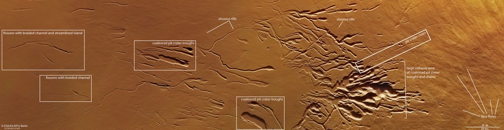
Map of the geological structures described in the text
The framed areas show various geological features on the southern flank of Ascraeus Mons volcano that are described in the main text. Starting from the higher regions in the north (right) and moving to the areas in the south (left) these are: solidified lava flows; a 6000-square-kilometre area of basin-like structures, pit crater chains and downslope chains of collapse basins; a pit crater chain; a sinuous rille; coalesced pit crater troughs; fissures with a braided channel; and fissures with braided channel and streamlined island.
The large volcanoes in the Tharsis region are testament to Mars' volcanically active past.
Thin, basaltic magmas built up shield volcanoes well over ten kilometres high.
The origin of the collapsed cavities on the flanks of the volcanoes still poses geological questions.
Focus: Mars, planetary research, spaceflight
These images, which were created using data acquired in Januar 2023 by the High Resolution Stereo Camera (HRSC) on board ESA's Mars Express spacecraft, show part of the southern flank of Ascraeus Mons, the northernmost of the three giant Tharsis volcanoes on Mars. HRSC is a camera system that was developed and has been operated by the German Aerospace Center (Deutsches Zentrum für Luft- und Raumfahrt; DLR) for more than 19 years. The results of the intensely volcanic past of Earth's outer neighbouring planet can be seen in the Tharsis region in a way that is visible in hardly any other region on Mars.
Ascraeus Mons is the northernmost and highest of the three shield volcanoes known as Tharsis Montes. These extend for 1000 kilometres along a northeast-southwest aligned topographic elevation, the Tharsis uplift, which is approximately five kilometres high and has an area roughly the same size as the continent of Europe. In the middle of this uplift, with a diameter of about 480 kilometres and a height of 18 kilometres, is Ascraeus Mons, the second highest mountain on Mars – it is only surpassed by the enormous, 24-kilometre-high Olympus Mons, which is located to the northwest of this volcano.
Collapsed lava channels on the slopes of the volcano
Ascraeus Mons is no longer active today. It has a very flat profile with an average slope of only seven degrees. The images show part of the volcano's southern flank. The difference in altitude between the left side (south) and the right side (north) of the image is approximately 10 kilometres. On Earth, such differences in altitude are found only on the four-kilometre-high shield volcanoes of the Hawaiian Islands, which rise out of the five-and-a-half-kilometre-deep Pacific Ocean. The unusual terrain shown here is called Ascraeus Chasmata – a huge area more than 70 kilometres in extent on the lower southern flank of the volcano, characterised by collapsed former lava channels.
Numerous structures of different ages and origins are visible in the images. Starting at the right edge of the images – 60 kilometres from the summit of Ascraeus Mons, which lies to the north east – numerous solidified lava flows can be seen (see annotated image), which are more visible in the colour-coded terrain image.
Basin-shaped structures, referred to as pit crater chains, are the dominant landscape element slightly to the south (centre of the image). Circular depressions following the topography and running downhill form chains of collapsed basins that connect to form elongated structures. This is how these 'chains' of troughs, each several hundred metres deep, are formed.
Unsolved mystery – how were the voids on Ascraeus Mons formed?
There is agreement that these structures were formed by the surface collapsing into underground voids. However, various processes are under discussion regarding the origin of these voids. They range from the intrusion of steeply upward, slab-shaped volcanic intrusions (referred to as 'dykes'), to cavities formed by chemical dissolution processes as are found in karst regions on Earth, to a combined origin involving both volcanic and tectonic processes.
The most widespread interpretation is that these structures are former 'lava tubes' that were formed when lava flowing on the surface passed over older, already solidified lava blankets and cooled rapidly on its upper side. However, the thin lava transported in them continued to flow down, the lava flow eventually stopped, and a tube-shaped void remained. Such empty lava tubes are also found on Earth; they are a frequently observed phenomenon on shield volcanoes with shallow slopes of only a few degrees, similar to Ascraeus Mons, and have diameters of several tens of metres.
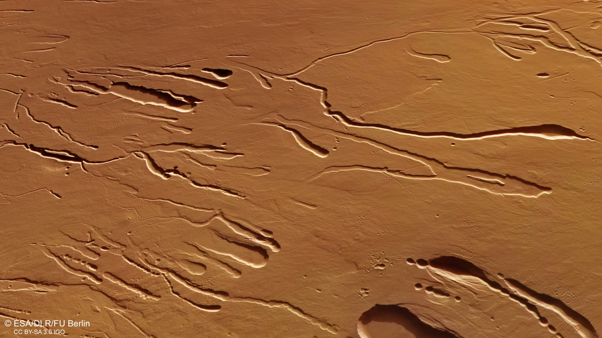
Meandering, downslope rilles with steep sides and flat bottoms are another common surface feature on the flanks of volcanoes. They are usually smaller than the pit structures and are characterised as rimless, sinuous channels. Starting from collapse structures, low-viscosity lava probably flowed continuously through them, eroding these narrow channels into a mechanically weak subsurface.
The left (southern) side of the images is dominated by several large fissures that reach lengths of up to 40 kilometres. Narrow, branching valley networks, similar to those of river systems, emerge from these fissures. Streamlined islands and terraces can be seen along the channel walls. This indicates that they were formed by water – not lava. It is thought likely that deposits of ice and/or snow accumulated on the flanks of the volcano and were buried under later volcanic deposits. They were then melted during a later, active episode of Ascraeus Mons, flowing away and eroding the valleys into the surface.
Image processing
The images were created using data acquired by the High Resolution Stereo Camera (HRSC) on 15 January 2023, during Mars Express orbit 24,045. The ground resolution is approximately 16 metres per pixel. The image is centred at 254 degrees east and nine degrees north. The colour images were created using data from the nadir channel, the field of view of which is oriented perpendicular to the surface of Mars, and the HRSC colour channels. The oblique perspective views were created using a Digital Terrain Model (DTM) and data from the HRSC nadir channel and the colour channels. The anaglyph image, which gives a three-dimensional impression of the landscape when viewed with red/blue or red/green glasses, was derived using data acquired by the nadir channel and one of the stereo channels. The colour-coded topographical view is based on a DTM of the region, from which the topography of the landscape can be derived. The reference body for the HRSC-DTM is a Martian equipotential surface (areoid)..
HRSC is a camera experiment developed and operated by the German Aerospace Center (DLR). The systematic processing of the camera data was carried out at the DLR Institute of Planetary Research in Berlin-Adlershof. Personnel in the Department of Planetary Sciences and Remote Sensing at the Freie Universität Berlin used these data to create the image products shown here.
The High Resolution Stereo Camera (HRSC) was developed at the German Aerospace Center (DLR) and built in cooperation with industrial partners (EADS Astrium, Lewicki Microelectronic GmbH and Jena-Optronik GmbH). The science team, led by Principal Investigator (PI) Dr Thomas Roatsch of the DLR Institute of Planetary Research, consists of 52 co-investigators from 34 institutions and 11 nations. The camera is operated by the DLR Institute of Planetary Research in Berlin-Adlershof.

