The large, 'wrinkled' aureole of Lycus Sulci at Olympus Mons
August 23, 2023 | Mars Express mission
The large, 'wrinkled' aureole of Lycus Sulci at Olympus Mons
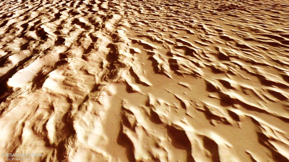
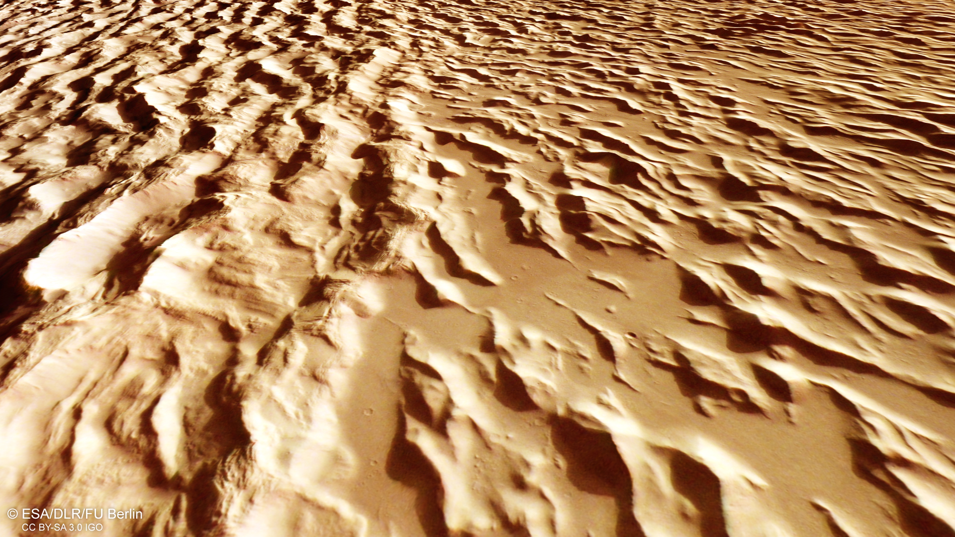
The 'wrinkled' landscape of Lycus Sulci
Like the frozen waves of an ocean, the chains of hills in Lycus Sulci (the 'furrows of Lycia') cover the Amazonis Planitia lowlands that lie to the northwest of the Olympus Mons volcano. This undulating area, characterised by long ridges and intervening valleys, stretches for hundreds of kilometres. This image is approximately 50 kilometres wide in the foreground. The characteristic undulating appearance of this landscape was probably created by compressing and spreading out of rock masses mobilised by lava flows as they were pushed over the landscape. Over time, this effect was accentuated by the erosion of less resistant material between the ridges.
Lycus Sulci to the northwest of the Olympus Mons volcano
During the landslides, huge rock masses broke off and slid from the lower slopes of the shield volcano over hundreds of kilometres onto the surrounding volcanic plains. The hills and ridges are covered with fine dust. Individual lobes of the aureole can be several hundred metres thick. Where they overlap, as in the left part of this image, they reach a thickness of more than 2000 metres.
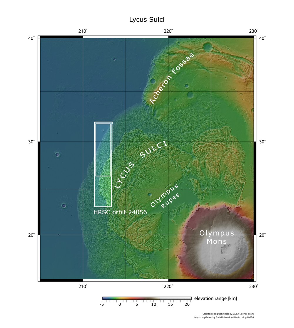
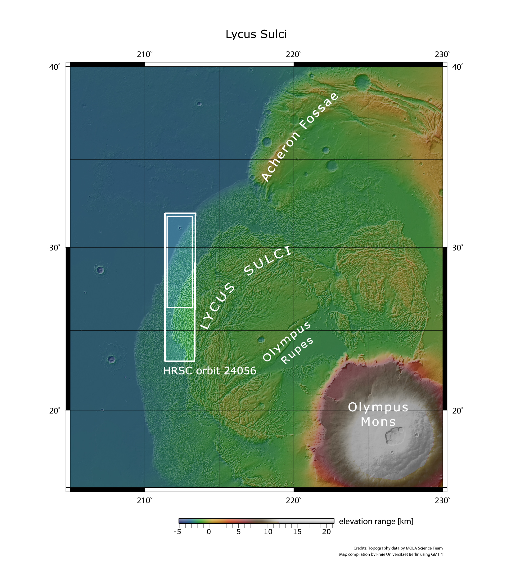
Topographic overview map of the Olympus Mons volcano and the northwest aureole
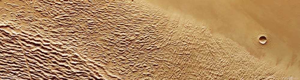
On 18 January 2023, during orbit 24,056, ESA’s Mars Express spacecraft imaged the Lycus Sulci region, which lies to the northwest of Olympus Mons. This area is characterised by chains of hills created by landslides and landslips along the base of the almost 22-kilometre-tall volcano. The image strip is approximately 95 kilometres wide. The landscapes shown in the images presented here are located in the inner rectangle in the northern part of the image strip.
Lava flows on Olympus Mons volcano probably melted ice in the ground, making the volcano flank unstable.
Rockfalls and landslides moved hundreds of kilometres into the surrounding landscape, forming a characteristic 'wrinkled' landscape there.
Today, steep escarpments, some over seven kilometres high, form the base of the volcano, exposing its 600-kilometre-diameter 'plinth'.
Focus: Mars, volcanism, Solar System exploration, spaceflight
Shortly after the discovery of the enormous, 21.9-kilometre-high Olympus Mons shield volcano on Mars by the US Mariner 9 spacecraft in 1971, planetary scientists observed that the volcano was surrounded by an aureole of distinctively patterned, 'wrinkled' terrain. The undulating landscape, characterised by long ridges and intervening valleys, stretches for hundreds of kilometres. Images of the largest aureole, named Lycus Sulci, located to the northwest of the volcano, are shown here. They were created using data acquired on 18 January 2023 by the High Resolution Stereo Camera (HRSC). This instrument was developed by the German Aerospace Center (Deutsches Zentrum für Luft- und Raumfahrt; DLR) and is operated by the DLR Institute of Planetary Research on board ESA’s Mars Express spacecraft.
Remnants of a collapsed volcano flank
These images tell the story of a catastrophic breaking off and sliding down of the lower, several-thousand-metre-high flanks of Olympus Mons, which occurred in the distant past. Planetary scientists suspect that the slides were triggered several hundred million years ago by large quantities of low-viscosity lava flowing down the flanks of Olympus Mons. These lava flows probably accumulated over strata that contained large amounts of water in the form of ice, similar to permafrost on Earth. The volcanic heat melted this ice so that the rim areas of the volcano became unstable and broke away, causing large masses of rock to slide off.
During the landslides, huge rock masses broke off and slid from the lower slopes of the shield volcano over hundreds of kilometres onto the surrounding volcanic plains. The characteristic undulating appearance of this landscape was probably created by compressing and spreading of the rock masses as they were pushed over the landscape. Over time, this effect was accentuated by the erosion of less resistant material between the ridges.
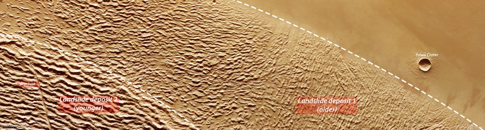
The hills and ridges are covered with fine dust. Individual lobes of the aureole can be several hundred metres thick. Where they overlap, they reach a thickness of more than 2000 metres. In addition, various lobes indicate that several collapse events have taken place. Two of these phases of activity can also be seen in the HRSC images (see labelled image). Here, the older slide (Landslide deposit 1) is overlain by a younger deposit (Landslide deposit 2), in which a large fracture (Fracture) can also be seen. Lycus Sulci, 'the furrows of Lycia' – named after the peninsula of Lycia in ancient Asia Minor, today located in southwestern Turkey – form a particularly aesthetically pleasing pattern that is displayed in these HRSC images, which have resolutions of less than 20 metres per pixel.
Two phases of landslide deposits
On the northwestern rim of Lycus Sulci, it can be observed that two of the landslide events overlap. While an older event deposited dust-covered hills with heights of a few hundred metres in the lowland Amazonis Planitia (Landslide deposit 1), the aureole to the northwest of the Olympus Mons volcano is more than 2000 metres thick where the deposits overlap (Landslide deposit 2). A tectonic extensional fracture can also be seen in the younger deposit (Fracture).
Even today, the base of Olympus Mons has tall scarps, some of which rise up to seven kilometres above their surroundings. Comparable landslides, albeit on a much smaller scale, are also found around terrestrial volcanoes. For example, the volcanic islands of Hawaii and the Canary Islands are surrounded in the ocean by debris from large rockfalls.
The similarity between the Martian volcanoes to their terrestrial counterparts disappears, however, when one looks at their dimensions. Olympus Mons, with a height of 21.9 kilometres and a diameter of 600 kilometres, is the largest and tallest mountain in the Solar System. Another example is the 8.2-kilometre-diameter Yelwa Crater, which can be seen in the right (northern) part of the HRSC images. It lies an incredible 1050 kilometres northwest of the caldera of Olympus Mons (which cannot be seen in the images published here).
Image processing
The images were created using data acquired by the High Resolution Stereo Camera (HRSC) on 18 January 2023 during Mars Express Orbit 24,056. The ground resolution is approximately 19 metres per pixel and the image is centred at about 212 degrees east and 28 degrees north. The colour image was created using data from the nadir channel, the field of view of which is oriented perpendicular to the surface of Mars, and the colour channels. The oblique perspective views were created using a Digital Terrain Model (DTM) and data from the nadir channel and the colour channels. The anaglyph image, which gives a three-dimensional impression of the landscape when viewed with red/blue or red/green glasses, was derived using data from data acquired by the nadir channel and one of the stereo channels. The colour-coded topographic view is based on a DTM of the region, from which the topography of the landscape can be derived. The reference body for the HRSC-DTM is a Martian equipotential surface (areoid).
HRSC is a camera experiment that was developed and is operated by the German Aerospace Center (DLR). The systematic evaluation of the camera data was carried out at the DLR Institute of Planetary Research in Berlin-Adlershof. Personnel in the Department of Planetary Sciences and Remote Sensing at the Freie Universität Berlin used these data to create the image products shown here.
The High Resolution Stereo Camera (HRSC) was developed at the German Aerospace Center (DLR) and built in cooperation with industrial partners (EADS Astrium, Lewicki Microelectronic GmbH and Jena-Optronik GmbH). The science team, led by Principal Investigator (PI) Thomas Roatsch of the DLR Institute of Planetary Research, consists of 50 co-investigators from 35 institutions and 11 nations. The camera is operated by the DLR Institute of Planetary Research in Berlin-Adlershof.
