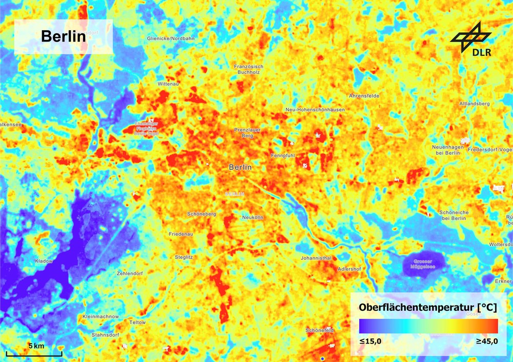
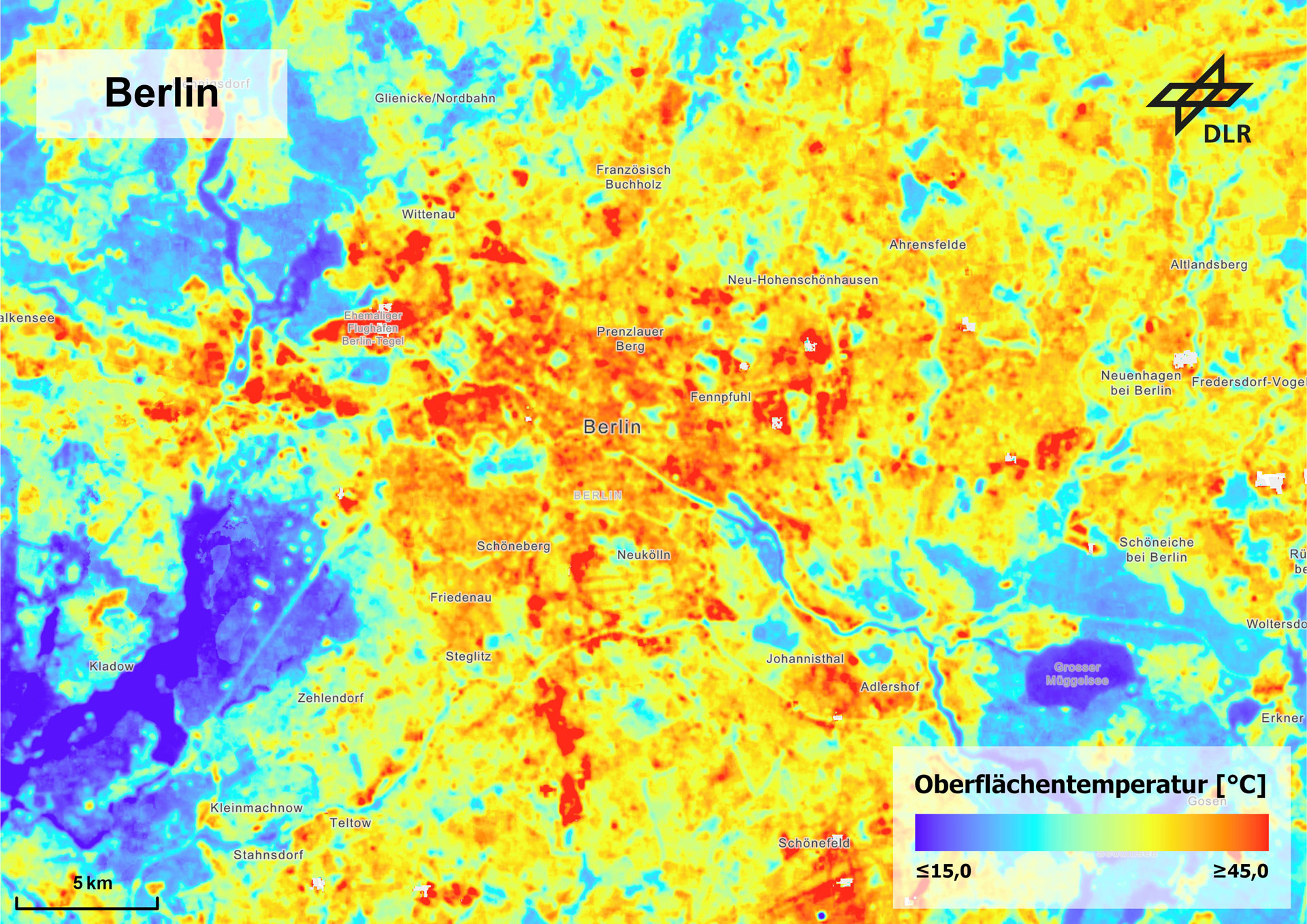
Average midday surface temperatures in the summer months of June, July and August from 2013 to 2024 for the greater Berlin area. The image shows how surface temperatures differ in built-up and non-built-up areas. Surface temperature and air temperature do not correspond exactly, but they are directly related and their spatial patterns are similar. Heat islands can therefore be clearly identified based on surface temperature.
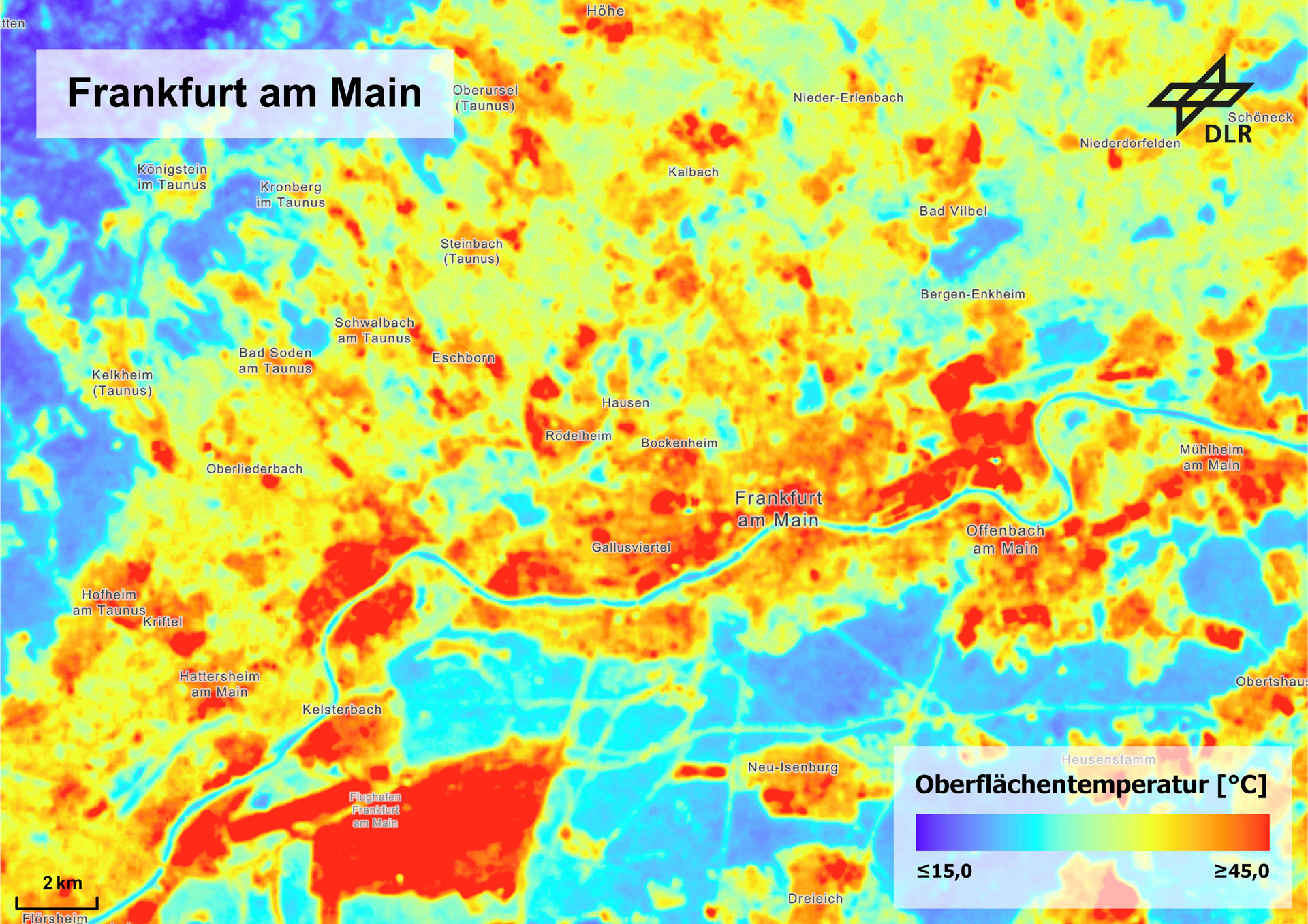
Average midday surface temperatures in the summer months of June, July and August from 2013 to 2024 for the greater Frankfurt area. The image shows how surface temperatures differ in built-up and non-built-up areas.
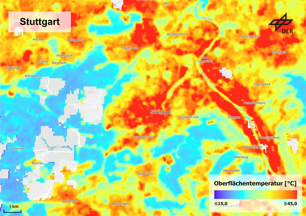
Average midday surface temperatures in the summer months of June, July and August from 2013 to 2024 for the greater Stuttgart area. The image shows how surface temperatures differ in built-up and non-built-up areas.
Researchers determined the surface temperatures for over 70 major cities in Germany.
The analysis was conducted for the months of June, July and August from 2013 to 2024.
Heat islands can be clearly identified based on surface temperatures.
Focus: Space science, Earth observation, knowledge exchange
For the first time ever, the German Aerospace Center (Deutsches Zentrum für Luft- und Raumfahrt; DLR) has conducted a systematic analysis of surface temperature distribution for cities with more than 100,000 inhabitants in Germany. This shows that hard surfaces increase heat stress in our cities, with elevated temperatures particularly prevalent in highly paved, densely built-up urban areas. For the major towns and cities selected – over 70, including Berlin, Munich, Frankfurt, Stuttgart, Cologne and Hamburg – this information is now spatially resolved and comprehensible based on geographical location and layout. The analysis of thermal images from US Landsat satellites provided a sound, data-based foundation for specific measures to combat heat in urban areas.
"Through its application-oriented research, DLR actively supports public stakeholders such as ministries, municipalities and authorities, as well as the private sector," says Anke Kaysser-Pyzalla, Chair of the Executive Board of DLR. "Through intensive knowledge exchange, DLR boosts the benefits of its technologies for society. Information from space is fundamental for an even better understanding of processes such as climate trends in cities and metropolitan areas. DLR-developed procedures and methods for processing satellite data can provide reliable data and applications for a wide range of recommendations for action."
DLR researchers examined the average surface temperatures for June, July and August between 2013 and 2024. Surface temperature and air temperature do not correspond exactly, but they are directly related and their spatial patterns are similar. This allows heat islands to be clearly identified based on surface temperatures. These are correlated with variables such as city size, location in Germany and location within the urban area. Urban structure types such as areas of single-family homes, large-scale housing estates and block developments are also taken into consideration. The researchers combined Earth observation data with urban climate models to simulate the temperature distribution in various urban areas in detail with a resolution as fine as one metre. These building-level simulations allow precise capture of important factors such as shading and exposure in specific areas, enabling targeted analysis of where heat stress is particularly high in the city.
Temperature differences between urban and rural areas
"Remote sensing has provided us with extensive data to identify, quantify and monitor spatial hotspots," says Thilo Erbertseder, a researcher in urban climate and health at DLR. "We can use this knowledge to reduce the impact of heat on urban populations." Erbertseder notes that from an environmental medicine perspective, heat stress on the human body depends not only on surface or air temperature, but also on factors such as humidity, wind speed and solar radiation. These factors can increase heat stress for local populations.
Animation: Surface temperatures for the greater Berlin area and inner city
Average midday surface temperatures in the summer months of June, July and August from 2013 to 2024 for the greater Berlin area and the inner city. The image shows how surface temperatures differ in built-up and non-built-up areas. Surface temperature and air temperature do not correspond exactly, but they are directly related and their spatial patterns are similar. Heat islands can therefore be clearly identified based on surface temperature.
Animation: Surface temperatures for the greater Frankfurt area and inner city
Average midday surface temperatures in the summer months of June, July and August from 2013 to 2024 for the greater Frankfurt area and the inner city. The image shows how surface temperatures differ in built-up and non-built-up areas. Surface temperature and air temperature do not correspond exactly, but they are directly related and their spatial patterns are similar. Heat islands can therefore be clearly identified based on surface temperature.
Animation: Surface temperatures for the greater Stuttgart area and inner city
Average midday surface temperatures in the summer months of June, July and August from 2013 to 2024 for the greater Stuttgart area and the inner city. The image shows how surface temperatures differ in built-up and non-built-up areas. Surface temperature and air temperature do not correspond exactly, but they are directly related and their spatial patterns are similar. Heat islands can therefore be clearly identified based on surface temperature.
"Detailed analysis shows that surface temperatures in inner-city and rural areas can differ by up to eight to ten degrees Celsius," says Hannes Taubenböck of DLR’s Earth Observation Center. The detailed insights into temperature distribution for individual cities or regions provide scope for further research. In a study conducted several years ago in Augsburg, DLR demonstrated that, during a heat wave, more than half of the population is exposed to persistently high temperatures – even at night. "The human body then struggles to recover from the heat, so health risks increase," says Tobias Leichtle, who led the Augsburg study.
Cooling with urban green spaces
Generally speaking, urban areas with low building density and a high proportion of green space exhibit smaller temperature differences from the surrounding area than densely built-up areas with less green space. Green and blue infrastructure – vegetation and bodies of water – have a significant impact on temperature, depending on their size. They are already being used as adaptation measures due to their cooling effect. Urban greenery is particularly effective at reducing urban temperatures, as borne out by a study conducted with the involvement of DLR researchers." These measures may seem obvious, but it is important to bear in mind that every city has conflicts of use between the need to adapt to climate change and the need for housing and transport infrastructure," says Taubenböck. "We want to provide knowledge that will enable more informed social and political decisions in this regard." Measures could include issuing targeted information to people in individual city districts during heatwaves, providing cool rooms, carrying out renovations with a view to protecting against heat, and implementing long-term urban planning interventions.
From remote sensing to climate-resilient cities
Future DLR analyses will investigate the impact of various adaptation measures on temperature. Looking back at the past makes it possible to compare urban development with temperature trends. At the same time, urban climate models will be coupled with remote sensing data to evaluate possible scenarios and planned measures. By providing these tools, DLR is contributing towards sustainable urban development.
How scientists calculate heat stress
To conduct their analysis, DLR researchers used data from US Landsat satellites from 2013 to 2024. These satellites fly over the entire Earth, allowing the instruments on board to survey the same area of Earth's surface on a regular basis. Flights over the major German cities took place in the late morning or around midday. The resulting data was used to calculate average temperatures for the summer months of June, July and August. The satellite instruments recorded surface temperatures, not air temperatures. For small-scale examples, such as the temperatures of individual streets, the researchers also simulated the air temperature. Systematic comparisons of particularly hot or particularly cool areas in the individual cities will follow in the coming months. All major German cities with more than 100,000 inhabitants were considered for analysis. The researchers are also keeping an eye on climate changes.
Air temperature data for cities are not available across the board, so local heat hotspots often cannot be detected through measurements. This makes it difficult to plan targeted actions. One solution is remote sensing, which allows for comprehensive surface temperature measurements with sufficient spatial resolution and temporal coverage. The surface temperature is measured in each case. In forests, for example, this is the treetops, and in lakes, the water surface.


