New addition to the Copernicus Earth observation programme
November 5, 2025 | Copernicus Sentinel-1D launched
New addition to the Copernicus Earth observation programme
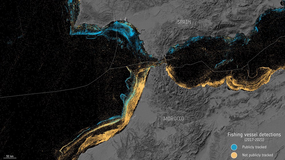
Sentinel-1 detects unknown fishing fleets
The map shows individual vessels detected by the Sentinel-1 mission between 2017 and 2021. Vessels that have reported their position to tracking systems are shown in blue, while those that have not are shown in orange. Using artificial intelligence, the ships were classified as fishing or non-fishing vessels. Ships not recorded in public monitoring systems can pose a challenge to the protection and management of marine natural resources.
Image: 1/4, Credit:
ESA
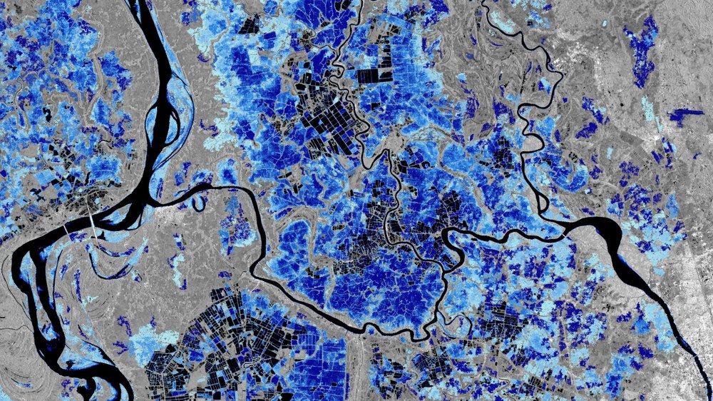
Mapping flood areas using Sentinel-1 data
The image shows areas in Myanmar that are frequently affected by flooding. The dark areas represent permanent bodies of water or fields that are regularly or permanently flooded, such as rice paddies. Different shades of blue represent flood frequency, derived from the Copernicus Sentinel-1 data archive; light blue indicates flooding less often, while dark blue shows more frequent flooding.
Image: 2/4, Credit:
ESA
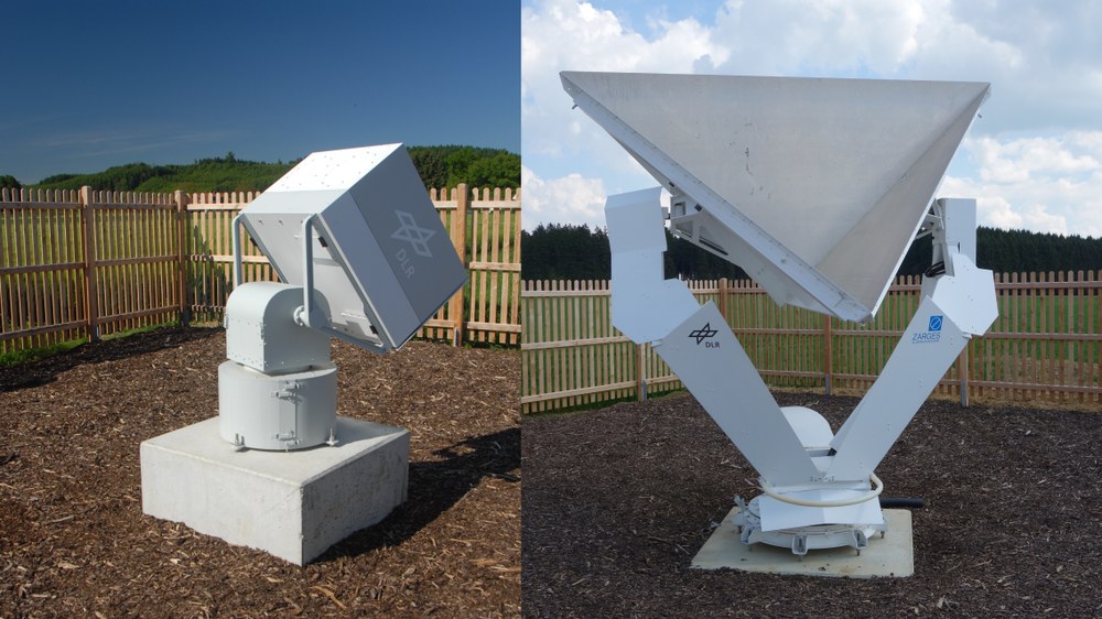
Transponder and corner reflector for the calibration of Sentinel-1D
The DLR SAR Calibration Center at the DLR Microwaves and Radar Institute has been serving as the central calibration facility for the Sentinel-1 mission since 2014. Transponders and corner reflectors provide reference targets against which the radar systems are calibrated. They are installed across a swath more than 100 kilometres wide to the west of Munich.
On 4 November 2025 at 22:02 CET (18:02 local time), the new Copernicus Sentinel-1D satellite was successfully launched from French Guiana.
The Sentinel mission provides essential data for monitoring the environment and infrastructure, as well as for disaster response.
The German Space Agency at DLR is supporting the programme on behalf of the German government.
DLR institutes are assisting with the calibration of the radar instruments.
Focus: Space, Earth observation, climate change
The Copernicus Sentinel-1 mission consists of two identical satellites in the same Earth orbit, imaging the planet's entire surface every six days. Sentinel-1D was launched on 4 November 2025 at 22:02 CET (18:02 local time) aboard an Ariane 62 rocket from Europe's Spaceport in Kourou, French Guiana. Following an overlapping operational phase, it will replace the Sentinel-1A satellite currently in orbit. Together with Sentinel-1C, launched in 2024, the two will form the new satellite pair. The German Space Agency at the German Aerospace Center (Deutsches Zentrum für Luft- und Raumfahrt; DLR) supports the Copernicus programme at the European level on behalf of the German government and promotes its use in Germany. The radar instrument on Sentinel-1D was built by Airbus in Friedrichshafen. DLR institutes in Oberpfaffenhofen provide assistance for the calibration of radar instruments.
Copernicus is Europe's largest and most successful Earth observation programme, comprising several parallel missions. The Sentinel-1 mission is equipped with a synthetic aperture radar (SAR) instrument capable of generating high-resolution images. These are captured day and night, regardless of cloud cover, and record the entire planet. Images from Sentinel-1 are needed for numerous applications in global land and ocean monitoring. Examples include climate change research, environmental management and disaster response – such as flood monitoring. The satellites can also detect subtle ground movements including uplifts, subsidence and slow landslides, as well as oil spills and ship movements.
Recently, data from the Sentinel-1 mission showed that approximately 75 percent of the global fishing fleet has been invisible to public tracking systems. Although not all ships are legally required to report their position, ships that are not recorded in public monitoring systems can pose a challenge to the protection and management of marine natural resources and safety at sea. Satellite data proves extremely valuable in this and many other areas.
Support from DLR
Teams at the DLR site in Oberpfaffenhofen are also involved in commissioning the satellite.
The DLR SAR Calibration Center at the DLR Microwaves and Radar Institute has been the central calibration facility for Sentinel-1 since 2014. As with Sentinel-1A, -1B and -1C, the SAR system on Sentinel-1D will also be calibrated from Oberpfaffenhofen following launch. Once the satellite has been inspected and the first functional tests carried out, the SAR instrument will be subject to a meticulously planned measurement programme. This calibration will use the highly successful concepts and procedures developed for TerraSAR-X and TanDEM-X, which have been refined for greater accuracy by the DLR calibration team for Sentinel-1. At the heart of the SAR Calibration Center are high-precision remote-controlled reference targets – transponders and corner reflectors – which have been installed as calibration standards across a swath more than 100 kilometres wide to the west of Munich.
DLR's Earth Observation Center (EOC) performs the geometric adjustment of the radar instrument using these ground-based radar reflectors. It also checks image quality, determines noise levels over calm, dark-looking ocean surfaces, and ensures that the radar images obtained meet the very high requirements for interferometric data evaluation. This work initiates before commissioning in orbit and continues throughout its operational life.
Background info: Interferometry
Interferometry refers to measurement methods that use the superposition or interference of waves – usually light, sound or, in the case of Sentinel-1D, radar waves. Sentinel-1's radar interferometry compares two radar images taken from the same position at different times. The slight difference in distance to the same objects in the two images enables even the smallest movements of Earth's surface to be calculated. Monitoring such movements over time reveals important information. For example, it is possible to determine where infrastructure is at risk from continuous subsidence, where mountain slopes are shifting or whether supposedly dormant volcanoes might be reactivating.
Copernicus is a collaborative programme between the European Union (EU) and the European Space Agency (ESA). Through this programme, the EU operates satellite-based information services for land surfaces (CLMS), oceans (CMEMS), the atmosphere (CAMS), disaster and crisis management (CEMS), climate change (C3S) and civil security (CSS). An increasing number of German authorities, researchers and innovative companies are also working with Copernicus data. The foundation of these applications and services lies in six satellite families, known as the Sentinels, operated by ESA in collaboration with the European Organisation for the Exploitation of Meteorological Satellites (EUMETSAT). The Sentinels provide vast volumes of images and measurements, all made available to users free of charge. This has led to numerous new government applications and private-sector products in Germany and across Europe – a trend that continues to develop.
In addition, a further six missions are currently being prepared, which will gradually expand the Copernicus fleet over the coming years. Among these is the Copernicus Anthropogenic Carbon Dioxide Monitoring Mission (CO2M), set to measure global greenhouse gas emissions from 2026. Copernicus also integrates satellite data from third parties, including data from the German satellites TerraSAR-X and TanDEM-X. Data portals such as Germany's Copernicus Data and Exploitation Platform (CODE-DE) ensure users have easy access to Earth observation data and processing tools.
