Raise the curtain as BIOMASS takes centre stage – Earth's 'lung volume detector'
June 24, 2025 | Space radar for precise biomass measurements
Raise the curtain as BIOMASS takes centre stage – Earth's 'lung volume detector'
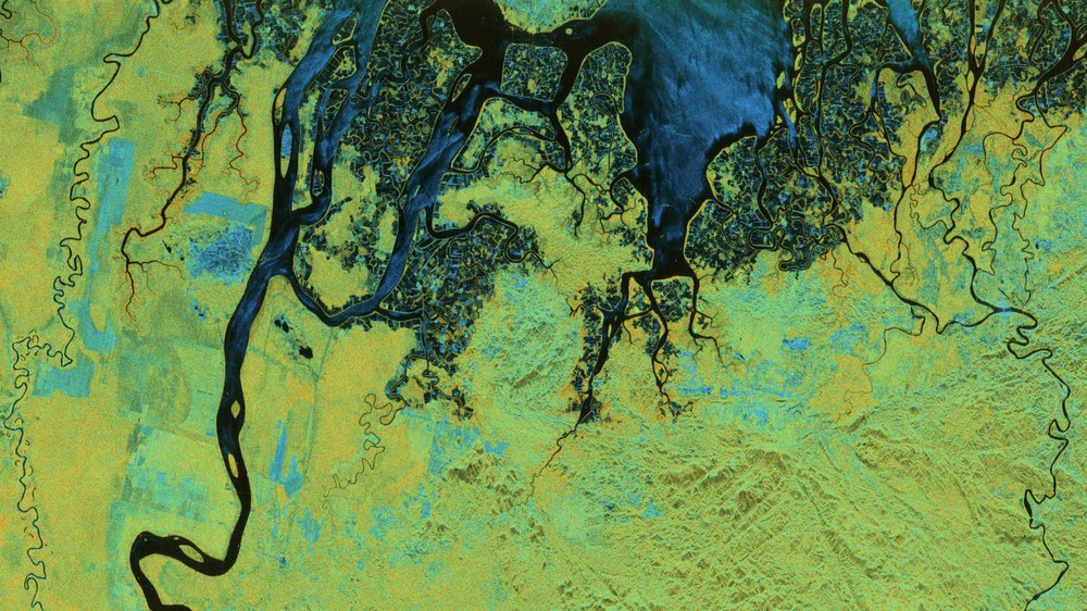
BIOMASS radar image – Tarakan on the northeast coast of Borneo in North Kalimantan, Indonesia
In the polarimetric image, water and unvegetated fields appear in shades of blue, while the forested areas appear in shades of red, indicating strong interaction between the ground and tree trunks. The flooded forests have a particularly intense red hue due to enhanced water-trunk scattering.
Polarimetric HSI representation (hue, saturation, intensity): The colour (hue component) indicates the type of scattering mechanism. Blue colours represent surface-like scatterers (like bare ground), green tones represent dipole-like scatterers (such as vegetation or volumetric scatterers) and red colours indicate dihedral-like scatterers (such as interactions between ground and tree trunks in forests or between ground and building walls in urban areas). These images and results were produced as part of the ESA-funded 'ESA Biomass In-Orbit Commissioning' project. All radar images were processed by DLR.
Image: 1/6, Credit:
ESA
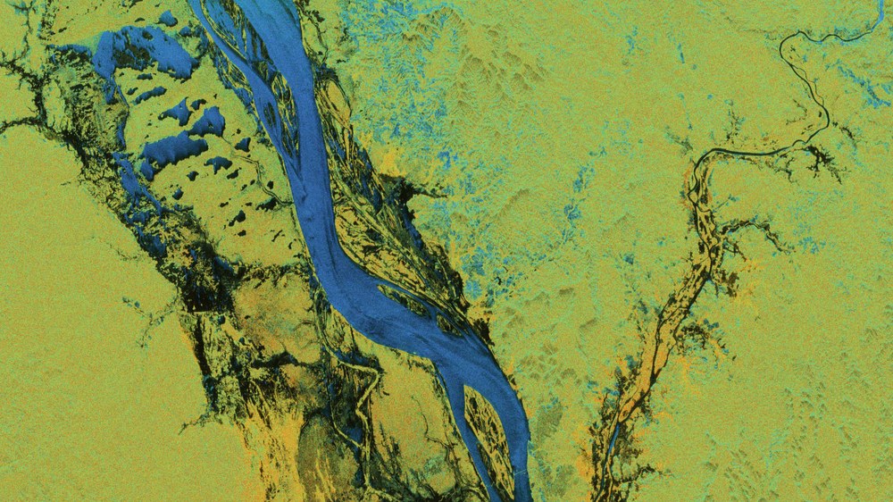
BIOMASS radar image – The Amazon river in the Brazilian state of Pará
The river and all bodies of water in the scene appear blue. The red hue in the forested areas on both sides of the river indicates significant ground-trunk interaction beneath the canopy – visible due to the penetration ability of the P-band radar.
Polarimetric HSI representation (hue, saturation, intensity): The colour (hue component) indicates the type of scattering mechanism. Blue colours represent surface-like scatterers (like bare ground), green tones represent dipole-like scatterers (such as vegetation or volumetric scatterers) and red colours indicate dihedral-like scatterers (such as interactions between ground and tree trunks in forests or between ground and building walls in urban areas). These images and results were produced as part of the ESA-funded 'ESA Biomass In-Orbit Commissioning' project. All radar images were processed by DLR.
Image: 2/6, Credit:
ESA
Biomass mission – accurately determining the biomass of our forests
ESA's Biomass mission is scheduled to launch on 29 April 2025, enabling the precise determination of global forest biomass for the first time. Germany is contributing over 20 percent to the mission and providing its main instrument. These contributions are coordinated by the German Space Agency at DLR. The DLR Microwaves and Radar Institute has conducted aircraft measurement campaigns to develop algorithms for estimating forest biomass, developed a prototype radar data processor, and created the software simulator for the German radar system.
The commissioning phase of ESA's BIOMASS Earth observation mission has begun.
The first radar images have been processed by DLR and preliminary data analysis reveals outstanding quality.
ESA and DLR are presenting the first radar images at ESA's Living Planet Symposium in Vienna.
The international geoscience and remote sensing community is excited about the initial results.
Focus: Space, Earth observation, radar technology
Following a smooth start to the commissioning phase of the European Space Agency's (ESA) BIOMASS Earth observation satellite, the BIOMASS team at the German Aerospace Center (Deutsches Zentrum für Luft- und Raumfahrt; DLR) has produced the first radar images. This is a real milestone, as they are the first focused Synthetic Aperture Radar (SAR) images ever captured from space in the P-band. The images and results were generated as part of the ESA-funded 'ESA BIOMASS In-Orbit Commissioning' programme.
The Launch and Early Orbit Phase (LEOP), during which the satellite was placed in orbit and its systems were activated and tested, concluded with the spectacular deployment of the 12-metre reflector antenna. The commissioning phase – In-Orbit Commissioning (IOC) – began immediately after, nearly two weeks ahead of schedule. The SAR instrument was switched on for the first time on 21 May 2025 and the first SAR image was taken the very next morning. On the same day, the first data sets were transmitted to Earth and appeared a few hours later on the servers of ESA's ground station segment at the European Space Research Institute (ESRIN) near Rome. At 16:20 CEST, DLR researchers at the Microwaves and Radar Institute in Oberpfaffenhofen, Germany, processed the first focused radar image.
The goal of the commissioning phase is to calibrate, characterise and verify the performance of both the instrument and the entire data acquisition and processing chain. Due to the highly innovative design of the BIOMASS mission, the planning and execution of this phase is more complex than for a conventional SAR system and is scheduled to last approximately six months. The satellite, ESA's seventh Earth Explorer mission, was launched on 29 April 2025 from the spaceport in French Guiana.
BIOMASS is not only the first space-based mission to operate in the P-band, it is also ESA's first fully polarimetric mission and the first to systematically acquire data from multiple angles. As such, numerous scientific and technical challenges had to be overcome during the course of its development, from the initial mission concept up to the moment it was ready for launch.
Background information:
Radar remote sensing
Radar technology is an important part of remote sensing because it works independent of weather and time of day. For example, optical cameras, which record in the visible spectrum, cannot deliver images in bad weather or at night, while radar can 'see' through even the thickest clouds and in complete darkness.
Radar transmits energy 'sideways' to the satellite's flight path. Depending on the wavelength, the specific signal reflected back varies based on the characteristics of the surface, which then generates the radar image. In Earth observation, different radar wavelengths are used, typically the X-band (3.1 centimetres), C-band (5.6 centimetres) and L-band (23.5 centimetres). The longer the wavelength, the greater the penetration depth of the radar, as longer waves, among other things, bend more easily around obstacles. P-band radar operates with particularly long microwave wavelengths between 66 and 71 centimetres, enabling it to penetrate much deeper into vegetation, sand and soil, for example, compared to shorter-wave radar frequencies such as those in the C- or L-bands. As such, P-band radar can detect hidden subsurface structures and internal forest structures. It provides unique data on soil moisture, terrain topography and the biomass of Earth – even under dense forest canopies or dry sand cover.
Polarimetry
A polarimetric radar satellite transmits electromagnetic pulses with their electric fields oriented in a specific direction – either vertical or horizontal. Similarly, the radar antenna and the radar system have two receiving channels that record the returned echo signals in both horizontal and vertical polarisation. This enables detection of all the polarisation states of the backscatter from Earth's surface, significantly enriching the radar data – particularly valuable for applications such as forest biomass or soil moisture measurements.
From the outset, DLR has played a significant role in the BIOMASS mission. Throughout all mission phases, DLR has supported ESA with the development of key algorithms for calibration, correction of ionospheric effects and forest biomass estimation using polarimetric SAR interferometry and tomography. From the very start, DLR has made important contributions to overcoming the complex challenges of this mission.
Now, DLR is playing a key role in the commissioning phase – particularly in the areas of system characterisation, polarimetric and ionospheric calibration and performance verification. In addition to calibration and validation tasks, various scientific investigations are already underway. These include characterising Earth's atmosphere – particularly the ionosphere – during the ascending (6:00 local time) and descending (18:00 local time) BIOMASS orbits. This involves particularly long SAR recordings, covering a distance of up to 12,000 kilometres, which capture very different areas of the ionosphere. Another key task is to analyse the temporal stability of radar interactions with forests in the P-band – crucial for combining multiple observation angles to generate the first tomographic 3D forest images.
The start of an exciting journey
During commissioning, the satellite, its SAR instrument and the entire data processing and transmission chain are gradually brought to full operational readiness. By the end of this phase in November 2025, BIOMASS will move into its operational orbit and begin regular data collection. The mission will then provide the international Earth observation community with comprehensive data to capture spatial patterns of biomass and forest height, monitor changes over time and, for the first time, reconstruct forest structures in 3D – fulfilling the mission objectives.
The images show the first BIOMASS radar data from the early commissioning phase, with the colours reflecting the polarimetric behaviour of the radar waves. Such detailed images were previously unattainable by any previous radar satellite.
Germany contributes over 20 percent of the BIOMASS mission's budget and is responsible for key technology work packages, including development of the radar instrument and central electronics by Airbus Defence and Space. Other German companies are also involved including DSI Aerospace, OHB System AG, ArianeGroup, TESAT Spacecom, United Monolithic Semiconductors, Rockwell Collins and the Center of Applied Space Technology and Microgravity (ZARM) in Bremen. A dedicated BIOMASS project office has been established at the Max Planck Institute for Biogeochemistry in Jena to coordinate the scientific use of BIOMASS. In close cooperation with the University of Jena, DLR and the Helmholtz Centre for Environmental Research, the office supports the national and international user community by providing information, identifying gaps and promoting exchange – for example through webinars, summer schools and tutorials. The German Space Agency at DLR coordinates these contributions.
Contact
Philipp Burtscheidt
Senior editor DLR media relations
German Aerospace Center (DLR)
Corporate Communications
Linder Höhe, 51147 Cologne
Tel: +49 2203 601-2323
Martin Fleischmann
Team leader Communications & Media Relations
German Aerospace Center (DLR)
German Space Agency at DLR
Communications & Press
Königswinterer Straße 522-524, 53227 Bonn
Tel: +49 228 447-120
Konstantinos Papathanassiou
German Aerospace Center (DLR)
Microwaves and Radar Institute
Radar Concepts
Münchener Straße 20, 82234 Weßling
Pau Prats
German Aerospace Center (DLR)
Microwaves and Radar Institute
SAR Technology
Münchener Straße 20, 82234 Oberpfaffenhofen-Weßling

