Xanthe Terra on Mars – a journey across the 'golden-yellow land'
October 1, 2025 | Mars Express
Xanthe Terra on Mars – a journey across the 'golden-yellow land'
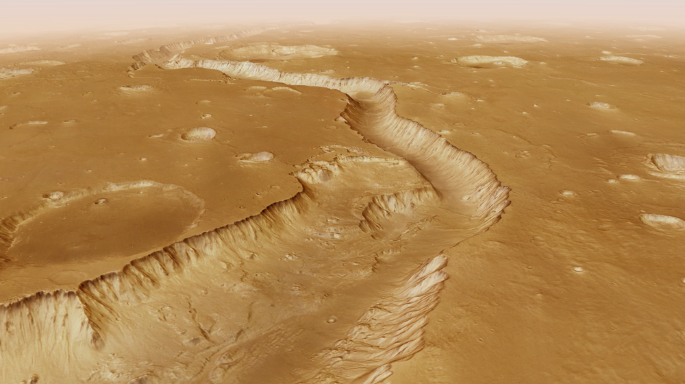
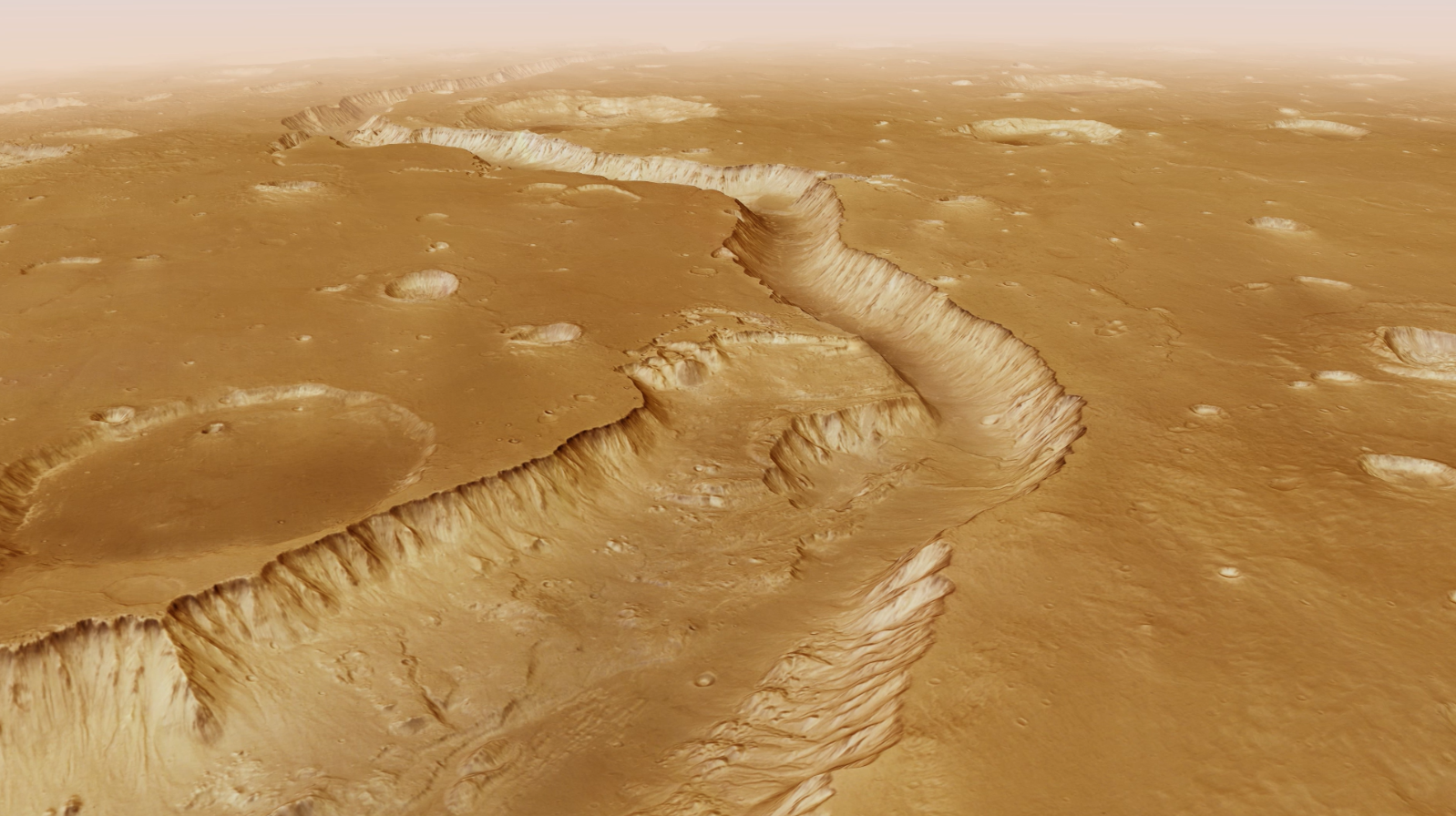
Shalbatana Vallis on Mars
Approximately 3.5 billion years ago, vast amounts of water eroded this deep valley into the Martian surface. Before reaching the lowlands of Chryse Planitia, it winds its way through the highlands for more than 1300 kilometres.
A new video based on data from the German HRSC stereo camera orbiting Mars shows a virtual flight from the Martian highland region of Xanthe Terra down to the lowlands of Chryse Planitia.
HRSC is a camera experiment developed by DLR and carried on ESA's Mars Express mission.
For 21 years now, the camera has been reliably delivering high-resolution image data from Earth's neighbouring planet.
Focus: Space research, Mars Express, HRSC camera
A new video takes Mars fans on a flight from the highland region of Xanthe Terra, down onto the Chryse Planitia lowland plain and back up to the mysterious 'chaos terrain'. The Xanthe Terra region was given its Latin name, meaning 'golden-yellow land', in the late 1970s. During the video flight, viewers cross the 'Martian dichotomy boundary' – a region where the heavily cratered southern highlands transition into the smoother plains of the northern lowlands. The film was created using data from the High Resolution Stereo Camera (HRSC) – a DLR-developed instrument onboard ESA's Mars Express spacecraft, which has been in operation since January 2004.
Why Mars shows this dichotomy between older highlands in the south and younger lowlands in the north, researchers have not reached a definitive answer. The flight over Xanthe Terra follows the course of the Shalbatana Vallis outflow channel down into the plains of Chryse Planitia, and from there southward again, moving 'upstream' through Simud Vallis into the rugged landscapes of Hydraotes Chaos.
Outflow channels are wide, deeply incised valley structures that likely formed in Mars’ geological past during catastrophic flood events involving enormous quantities of water. These events – sometimes episodic – may have been triggered by the sudden melting of large underground ice deposits as a result of increased volcanic activity in the region. In this respect, they differ from ordinary river valleys, which are formed by the continuous flow of water, tend to meander and are usually less straight.
A new video takes Mars fans on a flight across the highlands of Xanthe Terra, from Oxia Palus to the lowlands of Chryse Planitia. Along the way, the flight crosses the 'Martian dichotomy' – a boundary where the heavily cratered highlands gradually transition into the smoother lowlands.
Video – Flight over the Xanthe Terra region of Mars
Your consent to the storage of data ('cookies') is required for the playback of this video on Quickchannel.com. You can view and change your current data storage settings at any time under privacy.
Video – Flight over the Xanthe Terra region of Mars
A new video takes Mars fans on a flight across the highlands of Xanthe Terra, from Oxia Palus to the lowlands of Chryse Planitia. Along the way, the flight crosses the 'Martian dichotomy' – a boundary where the heavily cratered highlands gradually transition into the smoother lowlands.
Credit:
ESA/DLR/FU Berlin/NASA/MSSS
The journey begins in Shalbatana Vallis
Heading north, the journey starts with a flight over Shalbatana Vallis. Enormous volumes of water once carved this deep valley into the Martian surface. Before reaching the lowlands of Chryse Planitia, the channel winds its way for more than 1300 kilometres through the highlands – slightly longer than the Rhine, from its source in Switzerland to its mouth in the North Sea. Shalbatana Vallis is thought to have formed between the Middle and Late Hesperian periods, approximately 3.5 billion years ago. As the flight follows the valley northwards, numerous impact craters of varying sizes line the flight path – a hallmark of the older Noachian landscapes that formed even earlier, approximately four billion years ago.
After reaching the lowlands, the flight path turns sharply southeast across a landscape dotted with rounded hills along the southern edge of Chryse Planitia. The plain’s surface is smoother and has far fewer impact craters (clearly visible on the overview map) – a direct indication that these areas are younger than the highlands, which were exposed to asteroid bombardment for a longer period. Between the randomly scattered hills are a few small 'islands' with flattened plateaus. These are remnants of the former surface, left behind after the surrounding landscape subsided due to the disappearance of subsurface ice. For this reason, geologists call them mesas (Spanish for 'table') or, in German, Zeugenberge ('witness hills').
Travelling over chaotic terrain
Our 'flight' then heads back south into a region known as Hydraotes Chaos – a labyrinth of irregular mesas and hills rising to more than 1000 metres, separated by deep valleys. These give the region its distinctive 'chaotic' appearance, reflected in the technical name for such landscapes – chaotic terrain. Commonly found near the Martian dichotomy boundary, such terrain is often found at the sources of large, ancient outflow valleys. Hydraotes Chaos was, in fact, the subject of the very first image release from the Mars Express HRSC experiment – and again in 2014, this time in the form of a spectacular video.
The flight ends with a view of the Da Vinci impact crater, about 100 kilometres across. The crater floor is relatively flat and filled with rock material, but is overlain by a smaller, younger impact crater covered by a distinctive blanket of volcanic ejecta. The crater's lobe-shaped structure suggests that water or ice was present in the Martian subsurface at the time of impact.
Image processing and dataset
The video is based on a mosaic assembled from several HRSC images. This mosaic was combined with topographic data from a digital terrain model (DTM) to generate a three-dimensional representation of the landscape. The view is centred at 5 degrees north and 320 degrees east. For each second of film, some 50 individual images were generated following a predefined camera path across the scene. Vertical relief was exaggerated by a factor of three. Atmospheric effects such as clouds and haze were artificially added to blur the edges of the terrain model at distances of approximately 250 kilometres.
The HMC30 products include multi-orbit digital terrain models and orthorectified image mosaics derived from HRSC data, as well as secondary products such as pan-sharpened colour mosaics. These data products are organised according to a modified version of the USGS MC-30 tiling scheme. All HMC30 products are based on a bundle block adjustment of stereo images and are referenced to the global MOLA dataset.
The High Resolution Stereo Camera (HRSC) was developed at the German Aerospace Center (DLR) and built in cooperation with industrial partners (Airbus, Lewicki Microelectronic GmbH and Jena-Optronik GmbH). The science team, led by Principal Investigator (PI) Daniela Tirsch from the DLR Institute of Space Research (previously: Planetary Research), consists of 50 co-investigators from 35 institutions and 11 nations. The camera is operated by the DLR Institute of Space Research in Berlin-Adlershof.
