Better prepared – Earth observation data climate change adaptation
March 10, 2026 | EO4CAM data portal – Earth observation data for Bavarian public authorities
Better prepared – Earth observation data climate change adaptation
EO4CAM – Earth observation data for Bavaria
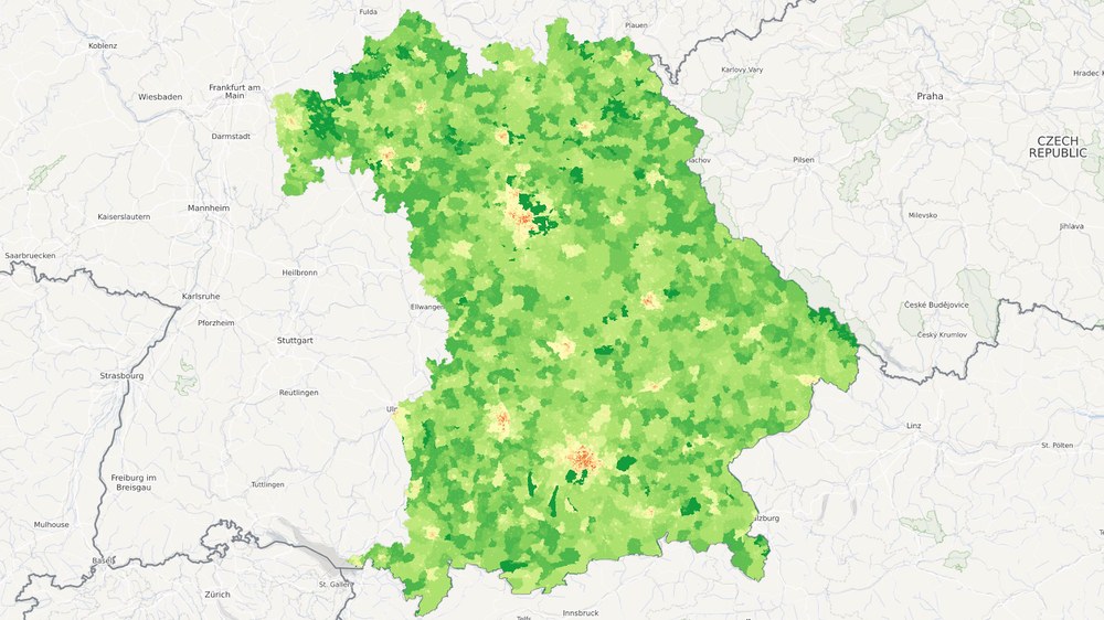
The EO4CAM data portal supports, in particular, applications in urban development, forestry, agriculture, geohazards, biodiversity and health. The dataset shown here provides information on the degree of urbanisation in Bavaria. The map shows the probability of urbanisation as a continuous percentage value – colour-coded from dark green (zero percent) through light yellow (50 percent) to dark red (100 percent). The map has a spatial resolution of 100 metres and is based on population figures, building density and the proportion of different building types.
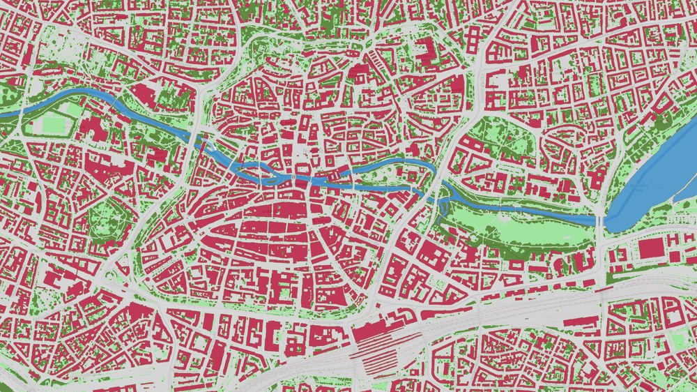
Built-up, green and water-covered areas shape the climate and water balance in urban areas and are therefore central to sustainable land-use planning. The blue-green-grey infrastructure map provides a detailed overview of the different land cover types. Five classes are distinguished at a spatial resolution of 20 centimetres: sealed open surfaces (grey), vegetated open surfaces (light green), tall vegetation (dark green), buildings (red) and water bodies (blue). The section shown here depicts Nuremberg city centre. Clearly visible are the ring road surrounding the Old Town, intersected by the River Pegnitz and, below it, the railway infrastructure of the city's central station.
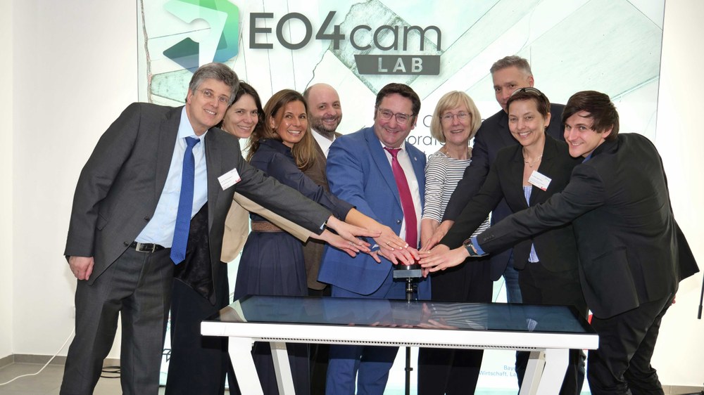
On 9 March 2026, the EO4CAM data portal was officially launched with a ceremonial event. Pictured (from left): Thomas Baier, Dean of the Faculty of Arts at the University of Würzburg; Doris Klein, Deputy Director of the DLR German Remote Sensing Data Center; Tanja Kraus, EO4CAM project manager at DLR; Tobias Ullmann, EO4CAM project manager at the University of Würzburg; Tobias Gotthardt, Vice Minister at the Bavarian Ministry of Economic Affairs, Energy and Regional Development; Caroline Kisker, Vice President of the University of Würzburg; Hannes Taubenböck, DLR; Anke Pagels-Kerp, DLR Divisional Board Member for Space; and Lucas Angermann, DLR.
Image: 5/5, Credit:
Robert Emmerich/University of Würzburg
The EO4CAM data portal supports Bavarian public authorities and municipalities with remote sensing-based information. This information is particularly useful for planning and evaluating measures to adapt to changing environmental and climatic conditions.
The data portal is now freely accessible to users from government, industry and the general public.
Focus: Space, Earth observation, supporting public authorities
On 9 March 2026, the EO4CAM (Earth Observation Laboratory for Climate Adaptation and Mitigation) data portal was launched. Using remote sensing data, EO4CAM provides precise, comprehensive information on processes of change across Bavaria. This gives municipalities and public authorities targeted support to better plan and evaluate measures for adapting to climate change, particularly in urban areas, agriculture, forestry, geohazards, biodiversity and health. The German Aerospace Center (Deutsches Zentrum für Luft- und Raumfahrt; DLR) is leading the project in collaboration with the Julius Maximilian University of Würzburg, with funding from the Bavarian Ministry of Economic Affairs, Regional Development and Energy.
Interfaces for public authorities and businesses
The information, presented in user-friendly maps and dashboards, is based on satellite data, in particular from the European Sentinel Earth observation satellite constellation, as well as official aerial imagery and other geospatial data. Standardised interfaces also allow the data to be integrated directly into public authority and company information systems or downloaded for further use.
EO4CAM is launching with a selection of different datasets for Bavaria. The data portal brings together products developed through many years of research with developments created specifically for the project. Additional datasets will be developed, updated and continuously expanded by the EO4CAM expert group over the coming years.
The EO4CAM project demonstrates how DLR conducts excellent research for the benefit of society. Providing remote sensing-based information for public decision-makers is a key priority for DLR, not only in Bavaria, but also throughout Germany and beyond national borders.
Tobias Gotthardt, Vice Minister at the Bavarian Ministry of Economic Affairs, Regional Development and Energy and Vice-President of NEREUS (Network of European Regions Using Space Technologies), is delighted, saying: "The launch of the data portal is a real milestone for the EO4CAM project. It brings Earth observation data out of research and to where it is needed – to public authorities and municipalities, to the places where decisions are made. Particularly in view of the increasing frequency of extreme weather events and the impacts of climate change, this data is worth its weight in gold, helping to identify developments at an early stage and enabling well-informed decision-making. With its research institutes, universities, space companies and innovative start-ups, Bavaria has the ideal conditions to unlock the full potential of these technologies."
Making urban areas more sustainable
The new EO4CAM web portal provides a long-term, and therefore sustainable, data foundation for questions relating to climate change adaptation and other applications. To make cities liveable, sustainable and resilient to climate change, sufficient unsealed surfaces must be preserved or incorporated into urban planning. Green spaces and water bodies help cool cities, improve the microclimate, promote biodiversity and reduce the risk of flooding.
To provide consistent, comprehensive information across Bavaria, remote sensing specialists from DLR and the University of Würzburg combine official survey data and aerial imagery, as well as digital landscape and surface models, with high-temporal-resolution Sentinel satellite data. Using an automated process, they produce maps containing detailed information on sealed, green and water-covered areas, at a resolution of up to 20 centimetres. The EO4CAM data portal also supports the monitoring of land use and the distribution and potential of rooftop solar installations.
Agriculture with a vision
Agriculture in Bavaria is already facing major challenges due to climate change. Rising temperatures, drought and heavy rainfall are affecting crop growth and yields. EO4CAM is designed to help better address both current and future conditions. The web portal provides comprehensive datasets on the management of arable land and grassland, as well as on landscape structure. Remote sensing data from space, aerial imagery and ground-based data are combined here in a targeted way.
Within the data portal, diagrams showing key indicators for grassland, arable land and hedgerows provide a quick overview. For arable crops, for example, annual yields per unit area and the proportion of land under cultivation can be accessed down to district level. The digital maps offer further insights at plot level, including detailed information on arable crops, mowing, hedgerows and yields in Bavaria.
Close collaboration with public authorities and other user groups has confirmed the urgent need for reliable, application-oriented information. For example, the hedgerow dataset is being incorporated into a joint analysis conducted by EO4CAM, the Bavarian Farmers' Association in Bad Neustadt and agricultural systems developer Agrokraft GmbH, which focuses on the economic valuation of hedgerows in agriculture.
Sustainable forest management
Changing environmental and climatic conditions, together with the resulting increase in pest infestations, have been causing significant losses in Bavarian and German forests for many years. EO4CAM therefore provides geospatial data to support nationwide monitoring of forest development and climate-adapted forest management.
The datasets include essential forest parameters such as canopy loss and canopy height, canopy cover, above-ground biomass, slope gradient and slope aspect. They are available at spatial resolutions of five to ten metres and as long-term time series with monthly to annual intervals, enabling analyses of forest structure and changes over time. Foresters and public authorities can therefore plan protective measures, timber harvesting, reforestation, forest access infrastructure and forest conversion in a sustainable way. The Bavarian State Forests organisation (Bayerische Staatsforsten; BaySF), for example, is already using EO4CAM data to identify damaged forest areas and plan further forest management measures.
Turning research innovations into practical applications
For the new data portal, DLR's Earth Observation Center (EOC) and the University of Würzburg contribute their many years of development work and expertise in the analysis and processing of Earth observation data. In addition, as part of the EO4CAM project, researchers are working on approaches that can be used to evaluate climate adaptation measures. These include, for example, urban climate and soil water balance models. This will enable public authorities to better estimate future effects that specific measures could achieve.
The EO4CAM data portal is an innovative tool for tackling the social and economic challenges posed by climate change. To this end, the EOC, in collaboration with the University of Würzburg, is putting Earth observation data and the latest research technologies into practice. The first data products are now available to users in politics, industry and the wider public throughout Bavaria.