For better winter weather forecasts – HALO measurement flights over the North Atlantic
January 14, 2026 | Major international NAWDIC project – atmospheric research over the North Atlantic
For better winter weather forecasts – HALO measurement flights over the North Atlantic
NAWDIC measurement flights
The DLR research aircraft HALO is operating at altitudes of up to 14 kilometres for the NAWDIC (North Atlantic Waveguide, Dry Intrusion, and Downstream Impact Campaign) measurement campaign. Using specially developed laser remote-sensing instruments on board, the research teams record continuous vertical profiles of wind, ozone and humidity between the aircraft and Earth's surface.
DLR research aircraft HALO during a measurement flight
The DLR research aircraft HALO is flying over the North Atlantic for the international NAWDIC measurement campaign. The aim is to gain a better understanding of the formation of storms, heavy rainfall and cold spells, and to improve weather models. This image shows HALO on 13 January 2026 carrying out measurements of cloud structures over France.
Image: 2/3, Credit:
KIT / Simone Scheer
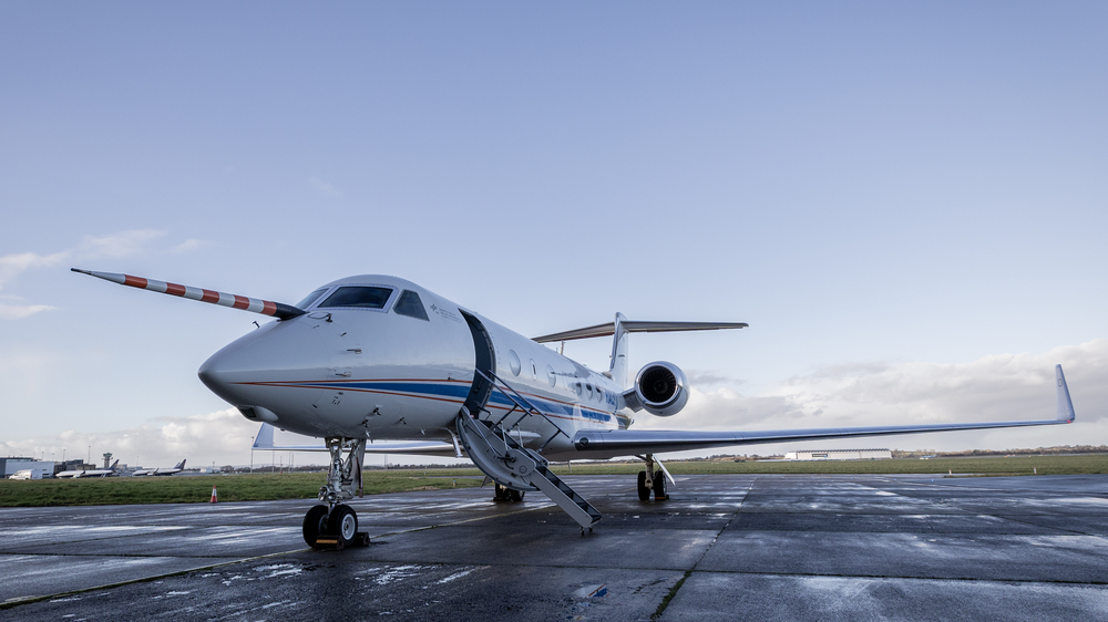
DLR research aircraft HALO at Shannon Airport, Ireland
The image shows HALO parked at Shannon Airport in Ireland. Thanks to its long range and scientific equipment, the DLR research aircraft is ideally suited to the wide-area NAWDIC measurement flights over the North Atlantic. The transatlantic airspace poses particular operational challenges in terms of flight operations. The DLR Flight Experiments facility is responsible for close coordination with air traffic control centres.
Image: 3/3, Credit:
ETH Zürich / Tuule Müürsepp
Weather phenomena over the North Atlantic lead to extreme weather events in Western Europe, especially in the winter months. However, the availability of data from the region remains insufficient.
With the NAWDIC measurement campaign, an international research team will investigate the dynamics of weather systems over the ocean in winter 2026.
Detailed measurements will be taken using the German research aircraft HALO, equipped with lidar measuring instruments from DLR.
The aim is to gain a better understanding of the formation of storms, heavy rain and cold spells, as well as to improve weather models.
Winters in Europe are characterised by strong winds, heavy rainfall and sudden cold spells. Many of these extreme weather events are linked to low-pressure systems that form over the North Atlantic. When these systems move towards Germany, they can create exceptional circumstances, cause expensive damage and, in extreme cases, endanger human lives. Just last week (the second week of January 2026), Storm Elli caused train cancellations, traffic chaos and school closures across Germany and parts of Europe. Many of the physical processes that lead to extreme weather in Europe develop over the Atlantic – a region that is inadequately covered by conventional observations and is therefore difficult to study scientifically. This is precisely where the international NAWDIC (North Atlantic Waveguide, Dry Intrusion, and Downstream Impact Campaign) measurement campaign comes in. Launched on 13 January 2026, NAWDIC aims to improve data for the North Atlantic through detailed airborne and ground-based observations over a six-week campaign. The German HALO (High Altitude LOng Range) research aircraft, operated by the German Aerospace Center (Deutsches Zentrum für Luft- und Raumfahrt; DLR), is playing a central role in this campaign.
NAWDIC, led by the Karlsruhe Institute of Technology (KIT), is significantly supported by the DLR Institute of Atmospheric Physics. Researchers from more than 30 further institutions in Europe and North America are working together within NAWDIC to improve the spatial and temporal accuracy of weather forecasts and further develop climate models.
Dry stratospheric air over the ocean a driver of extreme weather on land
A key scientific focus of the campaign are 'dry intrusions'. These dry, cool air masses descend from the upper troposphere and lower stratosphere towards the ground, influencing the weather. Especially in winter, they can lead to strong winds, turbulence and intense precipitation. Many of these atmospheric processes are still not adequately represented in today's forecast models.
"As part of NAWDIC, we aim to investigate processes that are not yet fully understood and that can cause severe winter weather events with significant impacts on society and the economy in Europe. To do this, we combine innovative measurement methods with the unique capabilities offered by the HALO research aircraft," says Andreas Schäfler from the DLR Institute of Atmospheric Physics, who is among those responsible for coordinating the NAWDIC HALO flights. The aim of the international research team is to use the measurements to gain a better understanding of the dynamics in the North Atlantic atmosphere, so that forecasts can be made earlier and more reliably. Since accurate forecasts of winter storms and associated extreme weather events are of central importance for public safety and the protection of critical infrastructure, NAWDIC also makes an important contribution to civil security research.
HALO seeks clues over the Atlantic
The HALO research aircraft's NAWDIC payload includes state-of-the-art lidar remote sensing technology from the Institute of Atmospheric Physics, enabling continuous vertical profiles of wind, ozone and humidity to be recorded between the aircraft and Earth's surface. HALO flies at altitudes of up to 14 kilometres (nearly 46,000 feet). Onboard HALO are the water vapour lidar instrument WALES and the wind lidar HEDWIG, which is being deployed on HALO for the first time. "By deploying these DLR-developed laser remote-sensing instruments in remote regions with low observation density, we are not only demonstrating the benefits of lidar technology as a complement to the global observation system, but also its suitability for future satellite-based lidar instruments," says Andreas Fix from the Institute of Atmospheric Physics. For the duration of the campaign, HALO will be stationed at Shannon International Airport in Ireland. Thanks to the aircraft's long range, it will be able to fly over a wide area of the North Atlantic, documenting water vapour transport and the interactions between the atmosphere and ocean over very large areas.
From an operational perspective, measurement flights over the North Atlantic place increased demands on planning and execution. The airspace is characterised by transatlantic traffic routes (known as NAT tracks) that are redefined on a daily basis and additional traffic outside these routes. The region also lacks continuous radar coverage. As HALO's operator, the DLR Flight Experiments facility is therefore responsible for close advance coordination with the relevant air traffic control centres. During flights, pilots ensure the safe and compliant integration of the research missions into international air traffic through predominantly data-based communication.
The aircraft-based measurements are complemented by ground-based observations using KITcube, KIT's mobile atmospheric observation system which has been stationed in Brittany, France, since November 2025. It consists of a network of remote sensing instruments that can detect atmospheric processes from a few metres to ten kilometres above the ground.
In total, more than 100 national and international scientists will be working for NAWDIC in the coming weeks to plan and carry out the flights from Ireland, maintain the measuring instruments and coordinate activities with international collaborators.
Thanks to long-term planning over the last six years in coordination with the World Meteorological Organisation (WMO), researchers have succeeded in linking NAWDIC with other meteorological measurement campaigns in North America that observe weather developments upstream. In January and February 2026, up to ten research aircraft, including HALO, will be in operation simultaneously ranging from the Pacific to Europe.
The KIT Institute of Meteorology and Climate Research – Troposphere Research (IMKTRO) is leading the deployment of HALO during NAWDIC in cooperation with the DLR Institute of Atmospheric Physics and the DLR Flight Experiments facility; Johannes Gutenberg University Mainz (JGU); Ludwig Maximilian University Munich (LMU) and the Forschungszentrum Jülich research institute. NAWDIC also consists of other independent components involving more than 30 institutions from Europe and North America. The WMO supports the project as part of its World Weather Research Programme.
About HALO
The HALO (High Altitude and LOng Range) research aircraft is a joint initiative of German environmental and climate research institutions. HALO was procured with funding from the Federal Ministry of Research, Technology and Space; the Helmholtz Association; the Max Planck Society; the Free State of Bavaria; the Forschungszentrum Jülich research institute; the Karlsruhe Institute of Technology and the German Aerospace Center.
HALO operations are supported by the German Research Foundation; the Max Planck Society; the German Aerospace Center; Forschungszentrum Jülich; the Karlsruhe Institute of Technology and the Leibniz Institute for Tropospheric Research, known as TROPOS. DLR acts as both the owner and the primary operator of the aircraft.


