Shaped by three natural forces – the landscape north of Eumenides Dorsum on Mars
January 7, 2026 | Mars Express
Shaped by three natural forces – the landscape north of Eumenides Dorsum on Mars
Landscape shaped by volcanic activity, wind and asteroid impacts
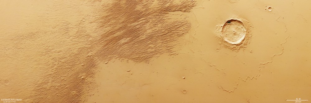
This offshoot of Amazonis Planitia lies west of the Tharsis region, which was shaped by intense volcanic activity. Its most striking features are long, streamlined ridges (dorsi) separated by narrow corridors. South of the large crater (on the left-hand side of the image), these structures – known as yardangs – were formed by wind erosion. To the southeast (bottom left), several small, more heavily weathered craters can be seen. In the east (lower of the image), lava flows are visible, presumably from the volcano Olympus Mons, which stands nearby to the east.
Topographic overview map of the southern Amazonis Planitia
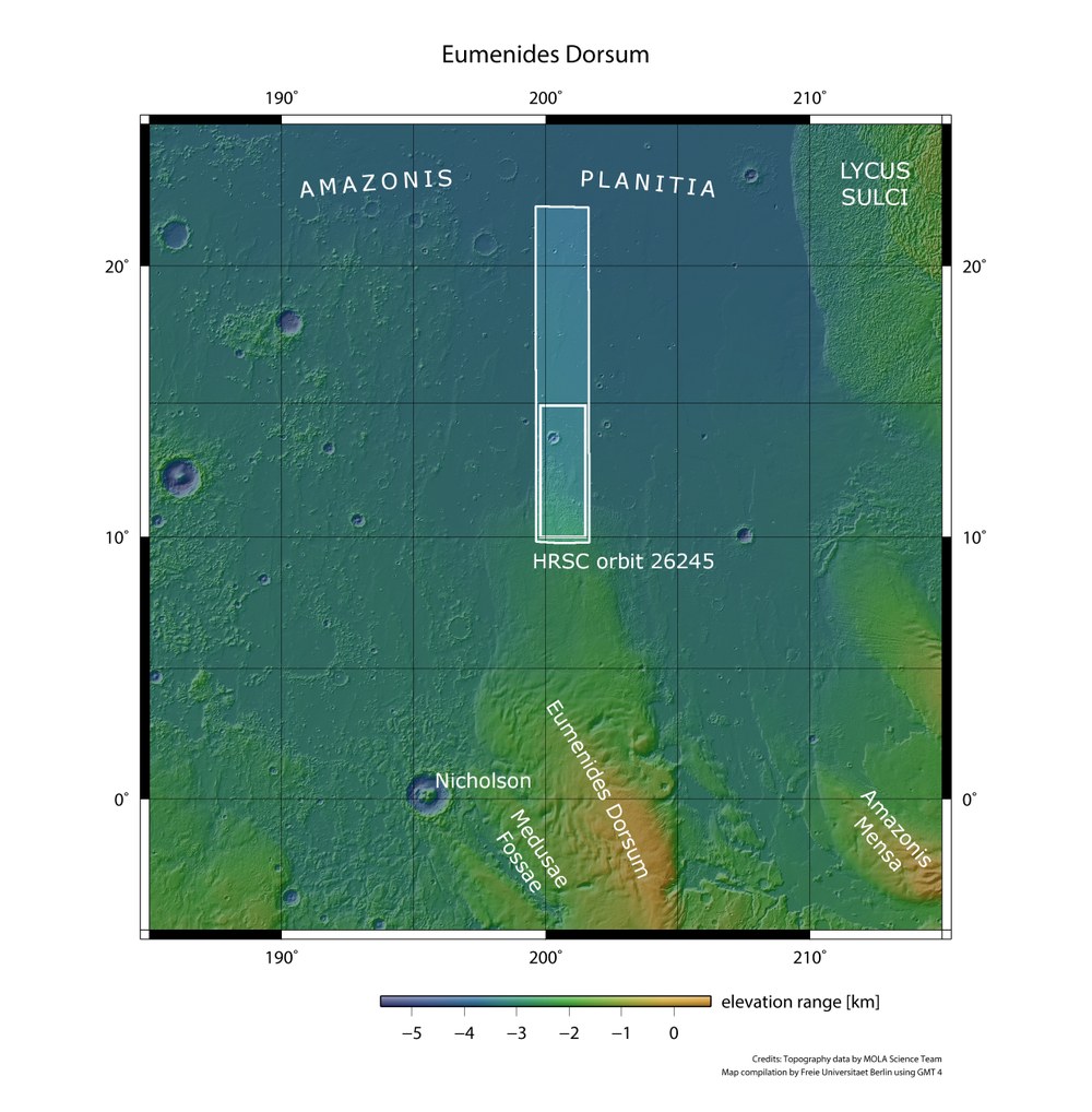
West of the extinct giant volcano Olympus Mons and north of the Martian equator lies Amazonis Planitia – a plain covering approximately two million square kilometres. It is named after the Amazons, a society of brave and powerful female warriors in Greek mythology. DLR's HRSC stereo camera on board ESA's Mars Express mission imaged the region north of Eumenides Dorsum and the adjacent lowlands on 16 October 2024, during orbit 26,245. The landscapes shown in this set of images are located within the outlined inner rectangle of the image strip, an area roughly the size of Belgium.
Image: 2/4, Credit:
NASA/JPL (MGS-MOLA) / FU Berlin
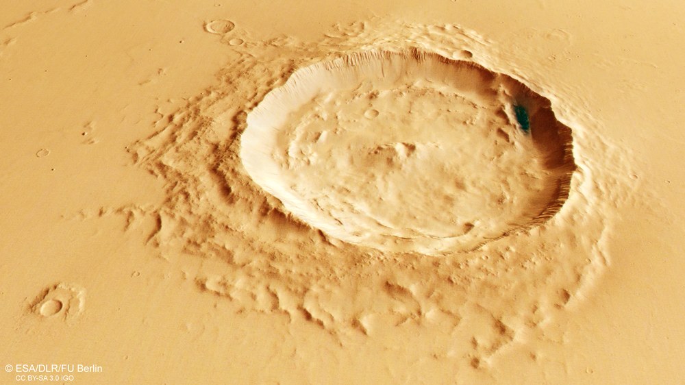
Perspective view of a relatively young crater north of Eumenides Dorsum
This crater measuring just over 20 kilometres in diameter, still has very sharp contours, a cohesive ejecta blanket and traces of landslides within it. The landslide material is deposited in a wave-like pattern, concentrically arranged around the crater rim. This suggests that the crater was formed by the impact of an asteroid no more than two kilometres in diameter in the not-too-distant geological past. Its dimensions are comparable to the Nördlinger Ries circular depression – also an impact crater – in southern Germany.
New images from DLR's High-Resolution Stereo Camera on board the Mars Express mission show a region north of Eumenides Dorsum.
This area is a striking example of how natural forces have shaped our neighbouring planet.
It is characterised by kilometre-long, streamlined ridges separated by narrow corridors.
Focus: Space, exploration, Mars
Volcanic activity, asteroid impacts and the raw power of the wind over vast periods of time – the region north of Eumenides Dorsum is a striking example of the interplay of natural forces on Mars. New image data captured by the High-Resolution Stereo Camera (HRSC) on board ESA's Mars Express mission provide evidence of the dynamic history of this region near the planet's equator. The HRSC is a camera experiment developed by the German Aerospace Center (Deutsches Zentrum für Luft- und Raumfahrt; DLR) and has been in operation since January 2004.
The area shown here is located west of the Tharsis plateau, on the lowland plain of Amazonis Planitia. The image detail shows an area of approximately 28,000 square kilometres – almost as large as Belgium – from different perspectives. Characteristic features include streamlined ridges, some several kilometres long, separated by narrow corridors.
Distinctive landscape features in the Martian lowlands
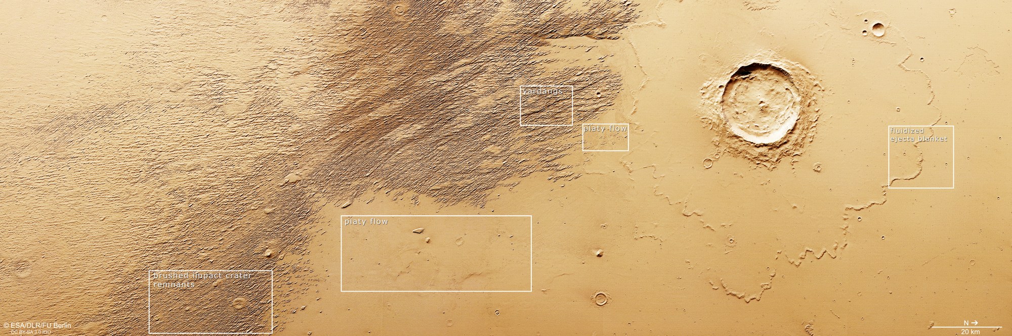
Traces of volcanic activity, asteroid bombardment and wind erosion are visible at the transition to the northern lowlands of Amazonis Planitia. Old impact craters formed by small asteroids have been almost completely erased by erosion (brushed impact crater remnants). Traces of volcanic activity are much more recent: runny lava flowed here from the adjacent eastern volcanic regions (in the lower part of the image) and solidified to form structures known as platy flows. A large expanse of parallel rocky ridges, known as yardangs, was formed by wind erosion. At the time of impact, ice must have been present in the subsurface, melting and fluidising the ejecta – as indicated by the shape of the deposits around the crater (fluidised ejecta blanket).
These structures, known as yardangs, are formed by the abrasive force of wind blowing persistently from the same direction. Carrying loose material such as grains of sand, wind acts like a sandblaster, scouring soft sedimentary rock along existing weak zones and gradually removing softer material. Since the wind direction remains constant, the resulting ridges are typically straight. The prevailing wind direction can be inferred from the shape of the yardangs: the broader end always faces into the wind, while the narrower end points downwind. As such, in this area, the wind that shaped the ridges has blown from southeast to northwest.
Impacts, eruptions, wind erosion – what came first?
In the flat area at the eastern end of the region (bottom of the annotated image), structures known as 'platy flows' – which resemble ice sheets, or floes – become visible after a significant increase in image contrast. These features, however, are actually lava flows, presumably from the volcano Olympus Mons, which stands nearby to the east. The surface of these flows cooled and solidified while molten lava continued to move beneath. The persistent movement below caused the solidified crust to fracture, producing characteristic fragments that now resemble plates floating on a sea of lava.
In addition to the large, 'fresh-looking' impact crater with its clearly defined ejecta blanket, smaller and significantly more weathered craters can be seen in the southeast of the landscape. Today, these are recognisable only as rounded elevations amid the yardang field and are referred to as brushed impact crater remnants. They formed earlier than the yardangs, as they have also been heavily eroded by the sandblasting effect of the wind. These crater remnants are likely to have retained their rounded shape because compaction of the ground during the asteroid impact produced more resistant material in specific spots.
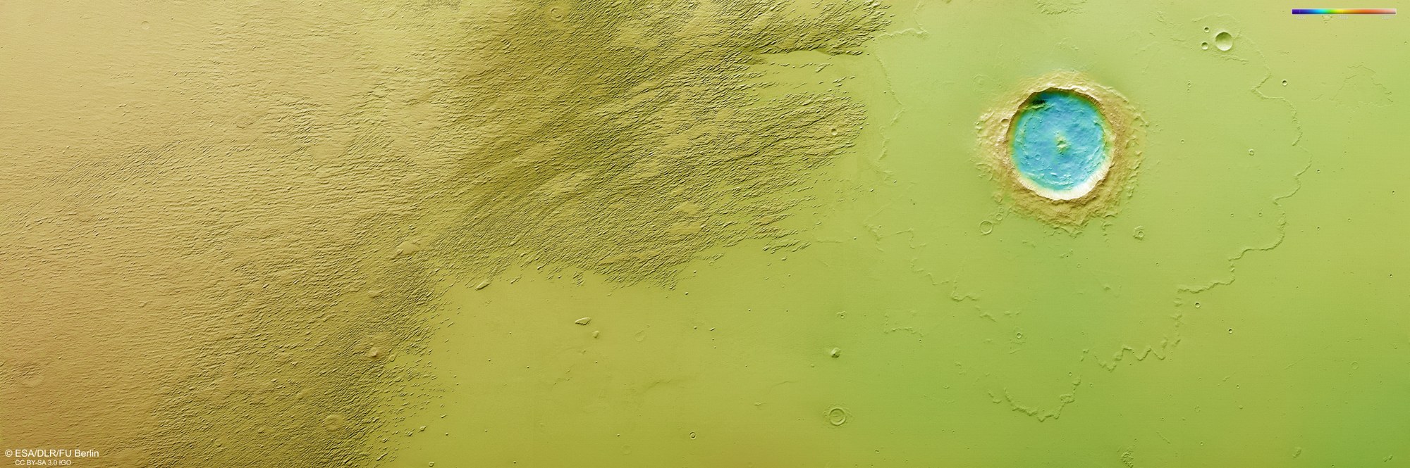
Topographic image of the region north of Eumenides Dorsum
DLR's High Resolution Stereo Camera (HRSC) on board Mars Express captures the Martian surface from multiple viewing angles using nine sensors. From this data, the DLR Institute of Space Research and Freie Universität Berlin generate digital terrain models. The colour scale at the top right of this image indicates the elevation values. The negative values indicate that this view is of the northern lowlands. The striking crater in the centre of the image measures just over 20 kilometres across and is approximately 1200 metres deep.
The co-occurrence of crater ejecta, lava flows and yardangs south of the large impact crater allows researchers to reconstruct the chronological sequence of the geological processes with considerable accuracy. Since most of the yardangs lie on top of lava flows, they must have formed later. This indicates that volcanic activity occurred here first, followed by an intense reshaping of the landscape by the wind. In all likelihood, the asteroid impact occurred later, leaving behind the large crater. This explains why ejecta covers the lava field and the yardangs terminate to the south of the crater.
As in many regions of Mars, a brief history of geological processes can be reconstructed from a landscape that does not appear particularly remarkable at first glance. However, the reason for the planet's topographical dichotomy – its division into southern highlands lying several kilometres higher than the extensive lowlands north of the equator – remains a mystery in the field of Mars research.
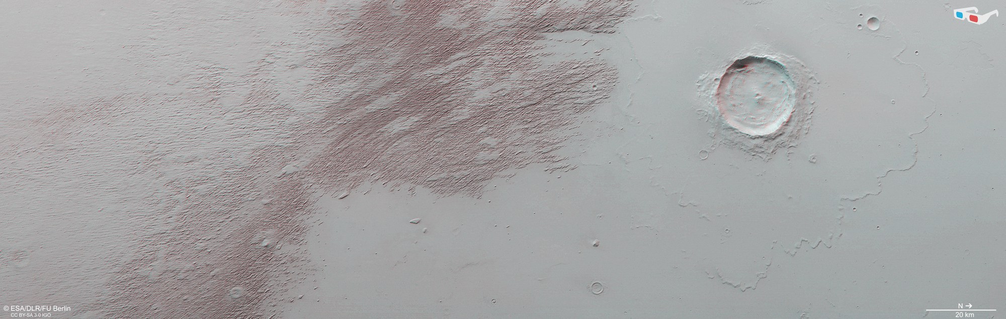
3D (anaglyph) image of the region north of Eumenides Dorsum
Anaglyph images can be generated from the nadir channel (which looks directly down at the Martian surface) and one of the oblique-viewing stereo channels of the HRSC. These images, when viewed with red–blue or red–green glasses, provide a three-dimensional view of the landscape. At approximately 20 metres per pixel, the high image resolution allows us to visualise even minor topographical features, such as the prominent impact crater in the centre of the image and the yardangs – ridges sculpted from rock by the wind – in the upper middle of the image.
The image data was acquired by the HRSC (High Resolution Stereo Camera) on 16 October 2024 during Mars Express orbit 26,245. The ground resolution is approximately 20 metres per pixel and the images are centred at approximately 12 degrees north and 200 degrees east.
The colour image was generated with data from the nadir channel, which looks straight down onto the Martian surface, and the HRSC's colour channels.
The oblique, perspective view was created from the digital terrain model, the nadir channel and the HRSC colour channels.
The anaglyph image, which produces a three-dimensional impression of the landscape when viewed with red–blue or red–green glasses, was derived from the nadir channel and one stereo channel.
The colour-coded topographic view is based on a digital terrain model of the region, from which the topography of the landscape can be derived.
The High Resolution Stereo Camera (HRSC) was developed at the German Aerospace Center (DLR) and built in cooperation with industrial partners (Airbus, Lewicki Microelectronic GmbH and Jena-Optronik GmbH). The science team, led by Principal Investigator (PI) Daniela Tirsch from the DLR Institute of Space Research (previously: Planetary Research), consists of 50 co-investigators from 35 institutions and 11 nations. The camera is operated by the DLR Institute of Space Research in Berlin-Adlershof.
