The chaos of Shalbatana Vallis captured by the HRSC Mars camera
May 13, 2026 | Mars Express mission
The chaos of Shalbatana Vallis captured by the HRSC Mars camera
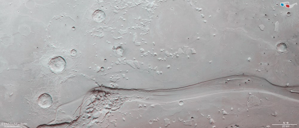
Fractured, 'chaotic' highlands in the Shalbatana Vallis channel
In the early history of Mars, vast quantities of water flowed across the planet. Numerous winding valleys provide evidence of a water cycle similar to that on Earth. However, large, trench-like channels suggest relatively short-lived outflow events, during which enormous volumes of water flowed rapidly and with great energy from the southern Martian highlands into the northern lowlands. Shalbatana Vallis is one such outflow channel, within which the characteristic 'chaotic terrains' also formed. It is thought that ice stored in the subsurface melted and drained away, causing the remaining cavities to collapse. The image spans approximately 30 kilometres.
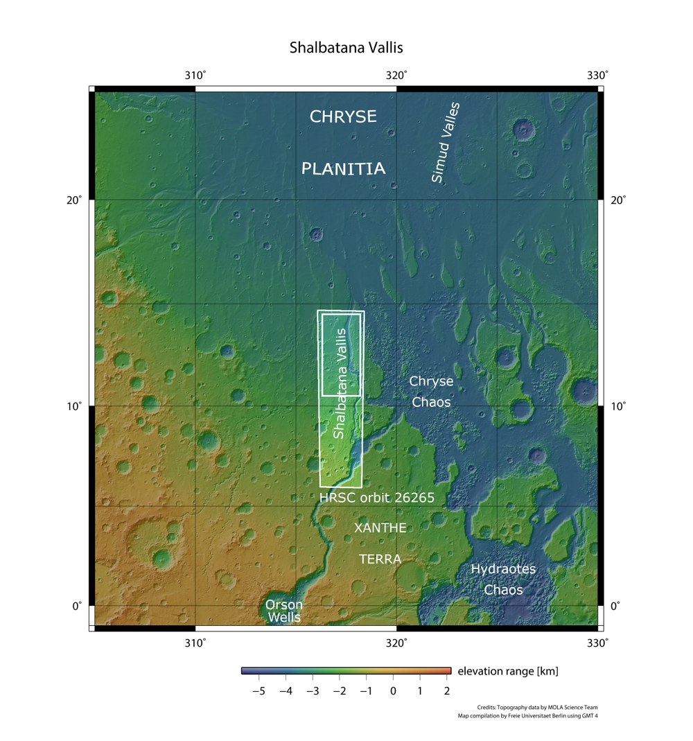
Regional overview map of Xanthe Terra and Chryse Planitia
The images presented in this release were acquired by DLR's HRSC on 22 October 2024 during Mars Express orbit 26,265. The ground resolution is approximately 22 metres per pixel. Shalbatana Vallis, located in the equatorial region of Mars, originates from the Orson Welles crater and formed approximately 3.5 billion years ago during the Hesperian epoch. At that time, vast volumes of water carved their way across more than 1300 kilometres, through the Xanthe Terra highlands down into the Chryse Planitia lowland basin.
Image: 2/5, Credit:
NASA/JPL (MOLA)/FU Berlin CC BY-SA 3.0 IGO
3D (anaglyph) image of the Shalbatana Vallis middle section
Using the nadir channel, which is directed perpendicular to the Martian surface, and one of the oblique stereo channels of the HRSC camera, ‘anaglyph’ images can be generated. When viewed with red-blue or red-green glasses, they provide a three-dimensional view of the landscape. The high resolution of 22 metres per pixel allows even the smallest topographic features to be visualised – in particular the collapsed rocks in the striking 'chaotic terrain' at the channel bend along the lower edge of the image, as well as the mesas rising from the ancient Xanthe Terra highlands.
New images from the German HRSC stereo camera show the middle section of the Shalbatana Vallis in the Xanthe Terra region of Mars.
The valley, stretching over 1000 kilometres, once drained the Martian highlands with a powerful water flow, leaving behind 'chaotic terrains'.
HRSC is a camera experiment developed by DLR aboard the European Mars Express mission, which has been reliably sending images of Mars back to Earth since 2004.
Using Digital Terrain Models based on HRSC data, researchers are mapping the planet's landscape topographically and visualising it in three dimensions.
Focus: Space, exploration, Mars
The Shalbatana Vallis outflow channel in the central Martian highlands is the subject of this image series, captured by the High Resolution Stereo Camera (HRSC) of the German Aerospace Center (Deutsches Zentrum für Luft- und Raumfahrt; DLR) on board ESA's Mars Express mission.
Shalbatana Vallis, located in the equatorial region of Mars, formed approximately 3.5 billion years ago during the Hesperian epoch. At that time, vast masses of water carved their way across more than 1300 kilometres through the Xanthe Terra highlands, flowing down into the Chryse Planitia lowland basin (see overview map). This region marks the transition between the heavily cratered southern highlands and the northern lowlands, which are considerably younger and so have significantly fewer impact craters.
Where the great channels meet
Outflow channels are broad valleys shaped by enormous volumes of water during extreme events lasting just a few weeks or months. They most likely formed by the rapid release of groundwater and subsequent flooding. These floods carried away material from the highlands, carving outflow channels into the landscape.
Shalbatana is not the only outflow channel in this region. Along the southern and western edges of the Chryse Planitia basin lie the mouths of Kasei, Ares, Simud and Tiu Valles. Here, the largest outflow channels on Mars converge in a star-like pattern. It was primarily for this reason that Chryse Planitia was selected as the landing site for the Viking 1 probe, launched nearly 50 years ago. Its lander touched down on 20 July 1976, approximately 200 kilometres north of the scene shown here.
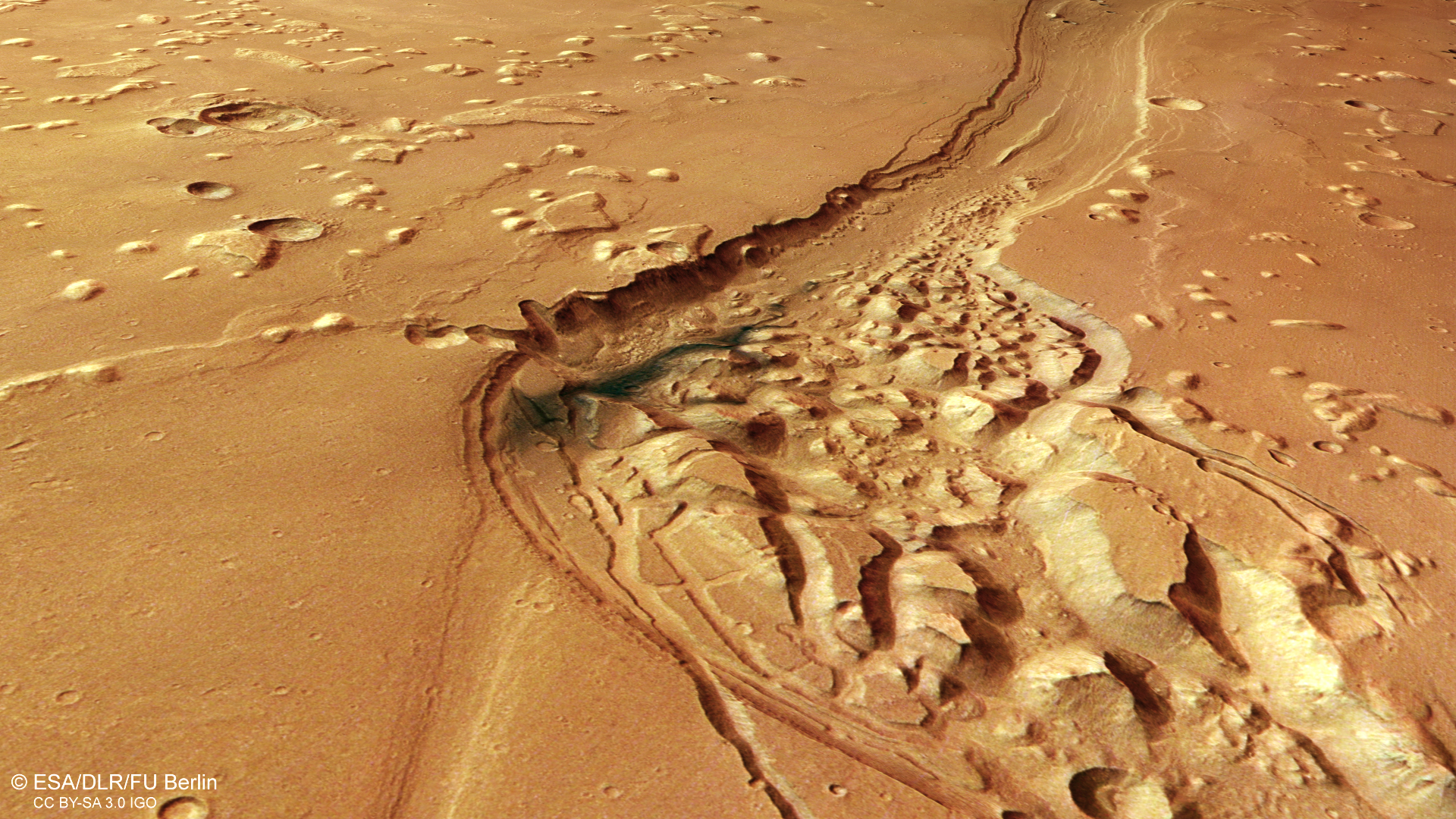
At the source regions of such channels, it is often possible to find 'chaotic terrain' – the technical term for a labyrinth of irregular mesas – flat-topped and steep-sided mountains – and hills, such as Chryse Chaos and Hydraotes Chaos (see overview map). Chaotic terrain is thought to be formed when subsurface ice melts and drains away, leaving behind cavities that later collapse. A small chaotic region is also visible in the image shown here (see annotated image: 'chaotic terrain and dark layer'), where a dark patch can also be seen. This is most likely dark volcanic ash deposited by the wind.
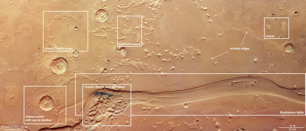
Landforms in and around Shalbatana Vallis in Xanthe Terra
The 'main attraction' in this approximately 220 by 110 kilometre section of the Xanthe Terra highland region is the Shalbatana Vallis outflow channel, with its chaotic terrain partly covered in dark volcanic ash ('chaotic terrain and dark layer'). To the south (left) lies a crater approximately 15 kilometres across, whose ejecta blanket is typical of impacts into water- or ice-bearing subsurface material (labelled 'impact crater with ejecta blanket' in the image). Higher in the image is a 25-kilometre-wide ancient crater completely filled with solidified lava, leaving only sections of the rim visible ('buried impact crater'). To the north of this, hills and mesas can be seen ('hills and mesas'), remnants of the ancient highland. Further north (right-hand side of the image), wrinkle ridges are visible, formed as low-viscosity lava cooled and contracted.
The source region of Shalbatana Vallis is the approximately 100-kilometre-wide Orson Welles impact crater, located in the Xanthe Terra highlands (see overview map). This crater also exhibits the characteristic chaotic fracture pattern associated with the terrain. It is named after the American director Orson Welles, whose 1938 radio drama 'The War of the Worlds' – depicting a fictional Martian invasion – caused a great stir.
The valley extends in an almost straight line from the left (southern) to the right (northern) side of the overhead views. The former riverbed is up to ten kilometres wide and approximately 500 metres deep, with a distinctly box-shaped cross-section. Compared to other outflow channels in the region, Shalbatana is relatively narrow. The nearby Ares Vallis, for example, is 25 kilometres wide – reaching nearly 80 kilometres at its mouth – with a depth of roughly one kilometre. The unusually shallow profile is characteristic of Martian outflow channels, which were carved out very rapidly and had little time to erode deep into Mars's surface. Shalbatana Vallis has also been filled with various materials over time and was originally somewhat deeper.
Shaping forces from below and above
It is not only the valley that has been filled in over time. Large impact craters on the surrounding plain have also been almost completely buried ('buried impact craters' in the image). Only small hills arranged in circular patterns – the remnants of former crater rims – hint at their existence.
The flat plateau is scattered with hills and mesa-like residual landforms ('hills and mesas'). These resilient remnants of a formerly continuous surface layer that eroded over time are known as 'inselbergs' (German for island mountains). The material filling the plain may consist of volcanic deposits. In some areas, the surface appears almost 'wrinkled' – a characteristic feature of cooled, contracted and compressed lava flows. These wrinkle ridges form when layered material cools, contracts at the surface and folds slightly.
Even before a tributary of Shalbatana Vallis carved its way into the volcanically filled landscape, the impact crater visible at the lower left of the image ('impact crater with ejecta blanket') already existed. Its ejecta blanket is cut through by the river valley. Nevertheless, the ejecta blankets of the three largest craters in this area have not yet been heavily eroded and remain clearly visible today.
Image processing
The images were acquired by the HRSC (High Resolution Stereo Camera) on 22 October 2024 during Mars Express orbit 26,265. The ground resolution is approximately 22 metres per pixel, and the image is centred at approximately 12 degrees north and 317 degrees east. The colour image was created using data from the nadir channel, which is aligned perpendicular to the Martian surface, as well as the colour channels of the HRSC. The oblique view was generated from the Digital Terrain Model (DTM), the nadir channel and colour channels of the HRSC. The anaglyph image, which creates a three-dimensional impression of the landscape when viewed through red-blue or red-green glasses, was derived from the nadir channel and one stereo channel. The colour-coded topographic view is based on a DTM of the region, from which the topography of the landscape can be derived.
The High Resolution Stereo Camera was developed at the German Aerospace Center (DLR) and built with industry contributors EADS Astrium, Lewicki Microelectronic and Jena-Optronik. The science team, led by Principal Investigator (PI) Daniela Tirsch, comprises 50 co-investigators from 35 institutions in 11 countries. The camera is operated by the DLR Institute of Space Research in Berlin-Adlershof.

