January 29, 2026 | DLR tests sensor-based assistance systems for inland navigation
Using sensors for mooring and lock manoeuvres
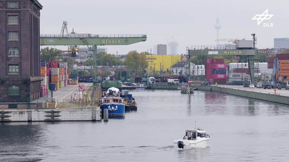
Travelling in the Spree-Oder waterway testbed
The DLR multi-purpose research vessel AURORA has been operating on the Spree-Oder waterway digital testbed, testing everyday navigation scenarios as part of II-RADAR-SOW. The research vessel entered locks, detected bridges and manoeuvred through narrow channels.
Radar-based assistance systems for inland waterway navigation
The II-RADAR-SOW project (Intelligent Industrial RADAR Sensor Network in the Digital Test Field on the Spree-Oder waterway) has seen DLR successfully develop and test navigational assistance systems for inland shipping.
The II-RADAR-SOW project has seen DLR successfully develop and test navigational assistance systems for inland waterway transport.
For the first time, millimetre-wave radar has been used under real-world conditions to map and detect inland waterways, laying the foundation for autonomous manoeuvring.
Over a period of two years, DLR's multi-purpose research vessel AURORA collected measurement data as part of the project, including on the Spree-Oder waterway digital test field.
The project contributes to the safe and effective navigation of inland waterways, for example with assisted mooring operations and early collision warnings.
Radar-based detection of other ships, quays and locks using millimetre-wave radar is intended to make waterway freight transport ever more safe and efficient, laying the foundations for autonomous inland navigation. The German Aerospace Center (Deutsches Zentrum für Luft- und Raumfahrt; DLR), together with regional industries and research institutions, is developing and testing advanced assistance systems for inland navigation. The Spree-Oder waterway digital test field, opened in 2024, served as the environment for measurements and data collection.
Assistance systems for enhanced safety on the water
Autonomous vessels will come to represent an efficient and innovative use of Germany's inland waterways. Narrow river sections, mooring manoeuvres and the operation of locks can cause delays and hazardous situations, particularly in heavy traffic and poor visibility. Electronic assistance systems that provide early warnings of collisions, or which can aid ship operators during mooring manoeuvres, are therefore fundamental to an efficient and safe inland navigation system of the future.
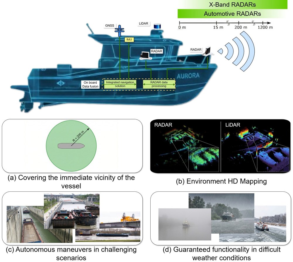
The DLR Institute of Communication and Navigation, together with the Brandenburg University of Technology Cottbus-Senftenberg and radar technology specialist InnoSent, has been developing and testing a millimetre-wave radar system that can complement existing on-board navigation systems. The project's measurement campaigns have demonstrated for the first time that radar-based mapping and object detection on the water is possible, even under challenging weather conditions.
In the wake of the AURORA
For two years, the DLR multi-purpose research vessel AURORA cruised the Spree-Oder waterway digital test field, among other routes, testing everyday navigation scenarios in the II-RADAR-SOW (Intelligent Industrial RADAR Sensor Network in the Digital Test Field on the Spree-Oder waterway) project. The research vessel navigated locks, detected bridges, and manoeuvred through narrow channels.
The millimetre-wave radar system reliably detected quay walls and riverbanks, opening up new possibilities for assistance systems and, in the future, for autonomous inland vessels. To measure position, distance and speed, radar and lidar work alongside dedicated camera systems to ensure robust navigation in all weather conditions.
Radar and lidar: a strong team
Lidar (Light Detection and Ranging) uses emitted light pulses to measure the shape and distance of objects or environments. From countless such light pulses, lidar can create exceptionally high-resolution 3D maps of objects. Environmental factors such as rain, fog or strong sunlight can, however, impair the measurement accuracy of lidar systems.
Radar (Radio Detection and Ranging) uses emitted radio waves that are reflected by surfaces to measure distance and speed. Through the reflection of radio waves, the distance and speed of objects can be calculated very accurately over long distances, unaffected by clouds or rain.
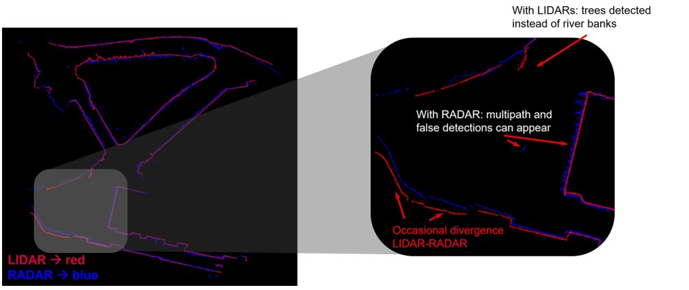
Overlay of lidar and radar data for quay wall detection
The red line shows the lidar measurements, while the radar measurements are shown in blue. The combination of these different navigation technologies may in future be used for fully autonomous or remotely-controlled inland vessels.
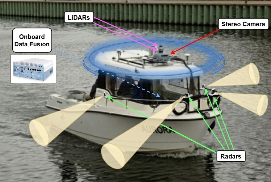
DLR has led the integration and measurement campaigns on board AURORA and also developed algorithms to generate three-dimensional representations of obstacles such as quay walls and bridges from the data collected.
In the future, the combination of radar and lidar navigation technologies could be used for fully autonomous or remotely-controlled inland vessels. Until then, the reliability of radar, lidar and cameras must be further investigated under a wide range of weather and lighting conditions, and their interaction digitally optimised.
II-RADAR-SOW is a project funded by the German Federal Ministry of Transport with the goal of increasing the safety and efficiency of inland shipping through the development, integration and testing of a new millimetre-wave radar system.
As part of the II-RADAR-SOW project, a sensor network for inland shipping applications was developed and tested, providing the basis for assistance systems on inland waterways. The project encompassed hardware design, data processing and the integration of the technology aboard DLR's multi-purpose research vessel, AURORA.
Between 2023 and 2025, four measurement campaigns were conducted on the Spree-Oder waterway digital testbed and other locations, covering various navigation scenarios including locks, bridges and narrow channels. DLR works regionally with the radar technology company InnoSent and with the Chair of Electronic Systems and Sensors at the Brandenburg University of Technology Cottbus-Senftenberg.
Contact
Melanie-Konstanze Wiese
Corporate Communications Berlin, Neustrelitz, Dresden, Jena and Cottbus/Zittau

