Although Earth is largely shielded from the dangers of interplanetary space by its magnetosphere and atmosphere, these do not provide absolute protection. The solar wind, a continuous stream of particles emitted from the Sun, compresses Earth's magnetosphere on the dayside and extends it into a long tail on the nightside. While most of the solar wind is deflected by the magnetosphere, some material still manages to penetrate. Understanding these processes is crucial for space-based infrastructure (such as satellite navigation and telecommunications satellites), and for the safety of astronauts on the International Space Station ISS.
Image: 1/4, Credit:
NASA
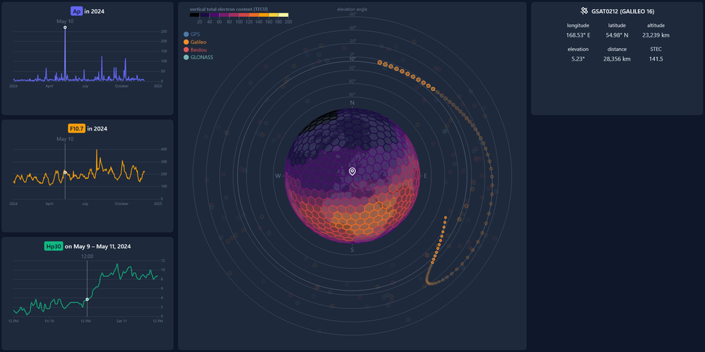
The ARIADNE dashboard
The ARIADNE web application visualises time series of global space weather indices (left), regional vertical total electron content (VTEC) and satellite positions (middle), as well as detailed information on a selected satellite (right).
Image: 2/4, Credit:
DLR DW-DMA
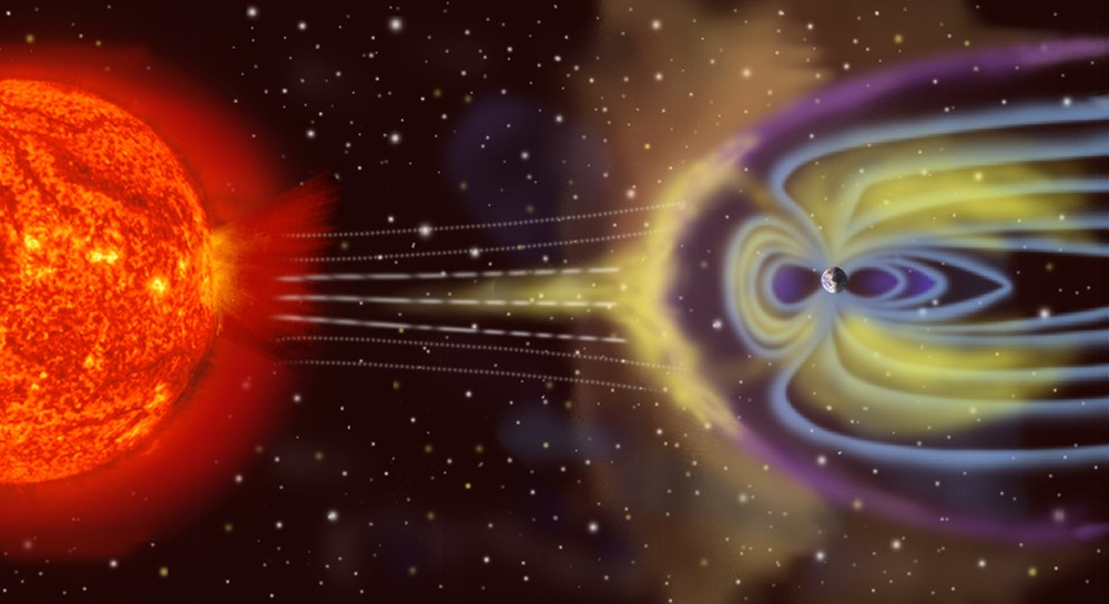
Visualisation of solar activity and Earth's magnetic field
Space weather manifests in many forms and affects both Earth and space. The impact of solar wind on the ionosphere affects satellites, aviation, energy systems, telecommunications and navigation. This is why space weather monitoring is of such great importance.
Image: 4/4, Credit:
ESA/A. Baker (CC BY-SA 3.0 IGO)
Advances in space weather research present significant challenges for data visualisation and the interactive exploration of complex datasets. The SWEET project (Space Weather Exploration and Evaluation Technologies), for instance, addresses the critical need for sophisticated visualisation systems tailored to space weather modelling – particularly for ionospheric and plasmaspheric data.
Space weather data consists of a wide variety of highly heterogeneous types. Existing applications – such as those from the National Oceanic and Atmospheric Administration (NOAA) and the European Space Agency (ESA) – focus on a few specific aspects and primarily offer static visualisations. The SWEET project aims to bridge the gap between data availability and accessibility by developing advanced interactive visualisation systems.
Data scientists working in this field take a holistic approach, dealing not only with the challenges of visualisation, but also the underlying technical requirements for efficient data processing, storage and user interaction. Many of these areas are not addressed by existing visualisation tools, such as geographic information system (GIS) mapping and data analysis technology.
Such work is especially timely given our growing dependence on satellite-based applications and the increasing demand for accurate ionosphere and plasmasphere models. Research aims to develop visualisation solutions that can effectively process diverse data sources while making complex space weather information accessible to a broader audience beyond the specialist scientific community.
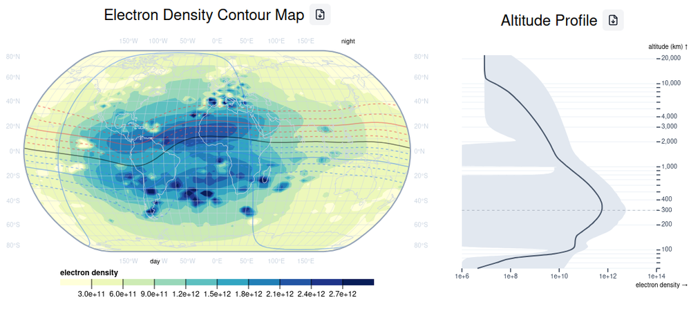
Screenshot of the SWEET demonstrator
The SWEET demonstrator provides access to an extensive dataset of pre-processed electron density observations based on the Neustrelitz Electron Density Model (NEDM) and the 3DVAR model. Data exploration yields maps and time series of electron density, vertical electron content and peak electron density measurements according to selected time and location.
Credit:
DLR DW-DMA (CC BY-NC-ND 3.0)
Space weather phenomena can have a significant impact on the performance of technological systems, notably on the accuracy of global satellite navigation systems. Given their widespread use, this poses a significant safety risk. Within the ARIADNE project, the DLR Institute of Data Science is focused on developing an interactive, web-based visualisation system to analyse the effects of space weather on satellite navigation. While electron density models in near-Earth space provide important data for analysing these effects, the resulting multidimensional datasets pose significant practical challenges for analysis and interpretation.
The project tackles these challenges with a two-stage approach:
First, by developing robust processing systems to handle electron density data and historical satellite orbits, enabling dynamic calculations of time series and slant total electron content (STEC) along satellite links.
Second, by creating an interactive web application that visualises these complex datasets via user-friendly interfaces, allowing dynamic selection of receiver locations, transmitting satellites and time periods.
This visualisation system is intended to support researchers and operators to better understand the impact of space weather on satellite navigation functionality through intuitive, interactive visual analysis tools.
ARIADNE also enables the processing and visualisation of critical space weather impacts on satellite navigation-based systems as part of the impulse project In2Action (Insight, Information, Action). This project also involves real-time analysis and evaluation of the integrity and precision of positional data in real time, prompting users to switch to alternative navigation systems if necessary. Two demonstrators will ultimately bring these systems into practical use for aviation at Cochstedt Airport and for shipping applications at Rostock Research Port.
The visualisation system will specifically address the challenge of presenting complex space weather phenomena in an accessible format that enables users to analyse effects on satellite-based and terrestrial communication systems with ease. This includes visualising the impact of space weather indices on performance parameters of satellite navigation systems, enabling improved estimates of the effect on navigation. The project aims to improve the safety and reliability of satellite navigation-based systems in critical applications, while making complex space weather data more accessible and manageable for end users through innovative visualisation solutions.
DLR Institute of Data Science
The Institute of Data Science seeks to develop and research methods that allow knowledge to be extracted from data, to drive innovation and to support decision-making. The Institute aims to create a comprehensive 'data backbone' by considering the entire data lifecycle – from the source to processing, through to machine learning and AI-based decision-making. To that end, the Institute of Data Science supports DLR's missions in the fields of aerospace, energy, transport and security through sustainable processes, resilient supply chains and robust decision-making tools.